

122-138 Menin Road, Oakville NSW 2765
This information is estimated by the OpenLot research team. Let us know here to provide up-to-date information about this development.
| Total new homes | 135 |
| Area size | N/A |
| Growth Region | Sydney North West Growth Areas |
| City council | Hawkesbury City Council |
| Developer | N/A |
| Project marketer | Century 21 Leading RE |
| Distance to | Sydney CBD - 38 km north-west Sydney Airport - 44 km north-west |
Land for Sale, House and Land Packages:
Popular Estates near 122-138 Menin Road, Oakville

River Oaks Estate - Vineyard

Stockland The Gables - Gables

Trinity North West - Oakville

Parkside Estate - Box Hill

Redgum Rise Estate - Oakville

Penfolds Estate - Vineyard

One Fairway Estate - Pitt Town

Landen’s Oakville Estate - Oakville

Harkness Place Estate - Oakville
Updates for 122-138 Menin Road, Oakville
Facebook updates:
Related news:
Your Home, Designed Your Way ! - 122-138 Menin Road, Oakville NSW 2765 - Vacant Land For Sale by Century 21 Leading RE

Sale by Negotiation - Deposit Finance Available !! - 122 - 138 Menin Road, Oakville NSW 2765 - Vacant Land For Sale by Century 21 Leading RE

Missing articles? Send us a link here.
Location & Map for 122-138 Menin Road, Oakville
Vacancy Rate in Oakville NSW 2765
View full vacancy rate history in Oakville NSW 2765 via SQM Research.
Schools near 122-138 Menin Road, Oakville
Here are 6 schools near 122-138 Menin Road, Oakville:
7-11 Catholic Secondary School
K-6 Government Primary School
K-6 Government Primary School
K-12 Independent Combined School
K-6 Catholic Primary School
U Government Special School
Suburb Planning Review in Oakville NSW 2765
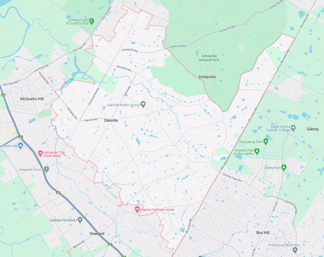
Oakville is approximately 14.6 square kilometres within the City of Hawkesbury, forming part of the Sydney Basin area in New South Wales, located 49 kilometres north-west of Sydney and located inland near the base of the Scheyville National Park.
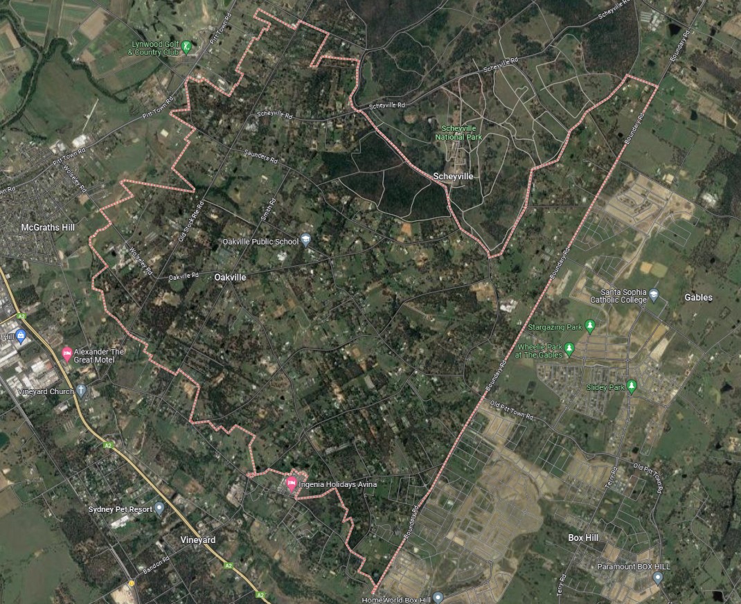
The suburb boundary is located along Old Pitt Town Road, Midson Road, Martin Road and Scholfield Road to the north and Boundary Road to the east. Property boundaries make up the entire western and southern boundaries. Windsor Road and Killarney Chain of Ponds run parallel together outside of the southern boundary.
Broos Road, Smith Road and Old Stock Rte Road provide local road access (north to south) and connect the local road network found throughout Oakville. Brennan Dam Road, Henry Road, and Chapman Road provide southern connections to surrounding suburbs, while Scheyville Road and Old Stock Rte Road are to the north. Menin Road and Old Pitt Town Road provide access to the east, while Wolseley Road and Saunders Road to the west.
The suburb of Oakville is primarily rural land holdings, with Oakville found to contain the southern portion of the Scheyville National Park, rural residential properties. The suburb does not have a business district, though contains recreational areas, natural watercourses, water holes, dams and in proximity to national parks. New urban development is occurring in the southern portion of the suburb, where the boundary has been amended to form the suburb of Vineyard. Stage 1 of the Vineyard Precinct has been recognised and approved for future urban development.
North West Priority Growth Area
Sydney’s North West will form part of the new approach to planning in NSW, following a review by the Department of Planning Industry and Environment in partnership with the Greater Sydney Commission and Government Architect. The decision was made to deliver 51 growth precincts, with the state government able to target areas and local councils empowered to get the correct planning for their community. The precinct planning will occur in four different pathways, being:
- State-led strategic planning
- Collaborative planning between the State and councils
- State-led rezoning
- Council-led rezoning
Oakville is not part of the growth area, however the southern portion of the suburb has been amended to form the suburb of Vineyard and forms part of the North West Growth Area. The area will proceed under the Strategic Planning method, with early work by the Department, councils, State agencies and communities in the development of places and the planning frameworks that support them.
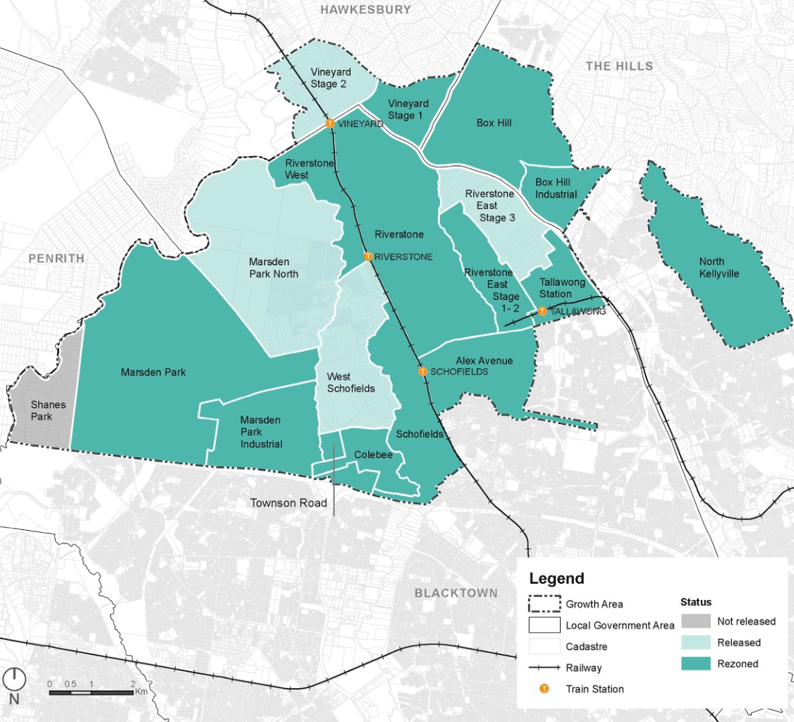
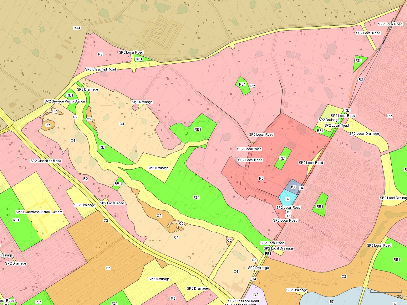
The Hawkesbury City Council prepared a Growth Centres Precinct Development Control Plan (DCP) that was adopted by the Secretary (or delegate) of the Department of Planning and Environment on 8 January 2018 and came into force on 18 January 2018, rezoning a portion of Oakville and amended the boundary for a new suburb of Vineyard.
The DCP was prepared to provide additional guidance to developers on how development is to occur in the Precinct and considerations undertake development in the Vineyard Precinct. The Council’s statutory development assessment will refer to the DCP and in conjunction with the Growth Centres SEPP.
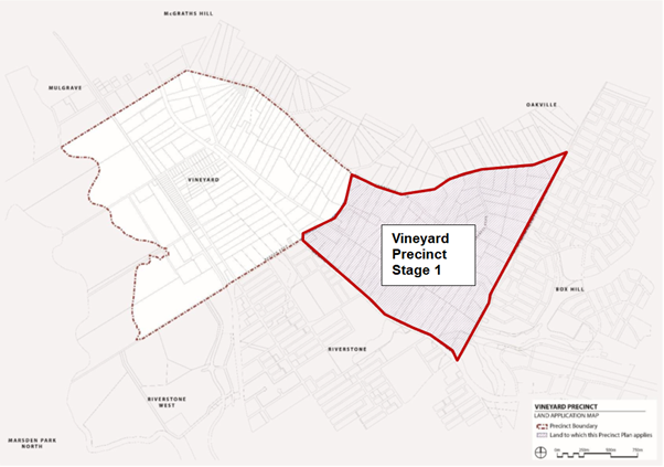
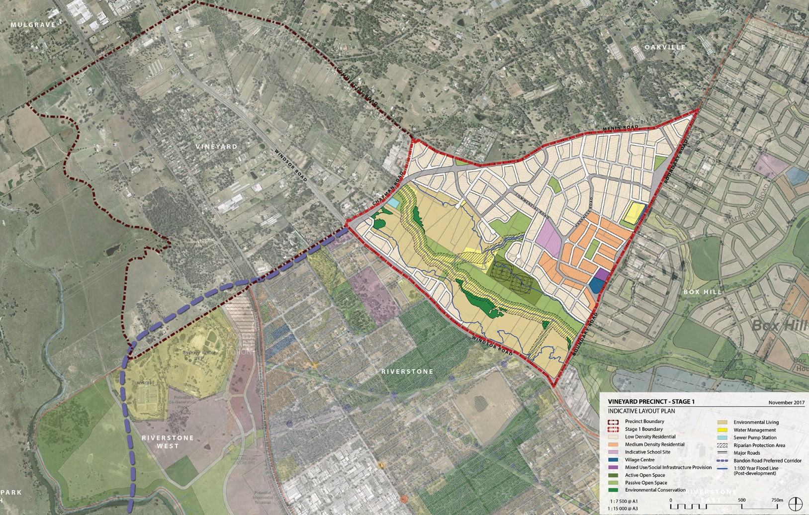
Eastern Precinct (Stage1)
The eastern portion of Vineyard and a southern portion of Oakville created the new Precinct., which set out the new road, open space and drain network for the area. The Precinct was provided with new density levels for residential areas, preferred new school location and retail, as well as environmental heritage values.
The New South Wales State Government aimed to provide a new precinct that was an attractive and well-connected community, in proximity to public transport, community facilities, open space and retail.
Vision
“Planning for the Vineyard Precinct responds to the need for new and diverse housing in Sydney that is well connected to major centres and employment, protects natural assets and encourages sustainable living. Consideration of the surrounding context, history and natural environment has informed the precinct planning process”.
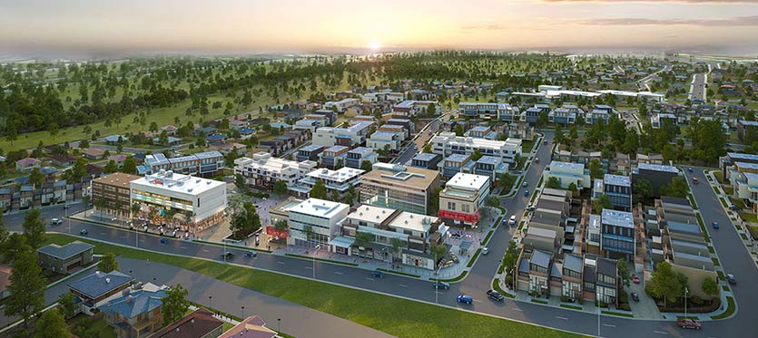
“The Precinct will consist of a mix of housing types that will allow for greater choice for different household types. It predominantly provides for low density housing, with some medium density around the village centre and open spaces”.
“Places of significant heritage value, particularly the Pitt Town Common House, have been integrated into the planning of the Precinct to ensure protection through a sensitive design approach. The village centre will support retail, commercial and community services to promote community interaction”.
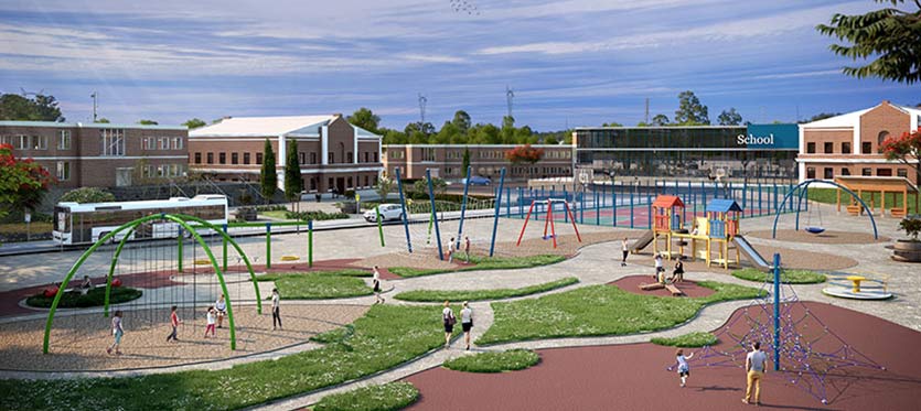
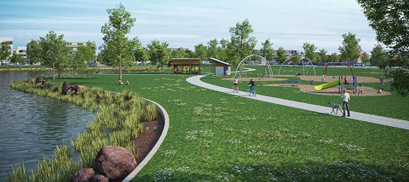
“Regional public transport accessibility has been provided through road connections to the nearby Vineyard railway station and a regional bus network along the major roads. A safe and permeable street network will promote accessibility, connectivity and social interaction. The provision of cycle ways and pedestrian connections, as well as public transport connections to surrounding centres, will promote a community that is less dependent on private vehicle use”.
Precinct Zoning
The existing zoning will be amended to provide for future infrastructures to facilitate future development within the Hawkesbury City Council Growth Centres Precinct. A new village centre including a supermarket and some community facilities is planned to meet the local shopping needs of future residents.
A new road network has been designed to help provide safe streets for residents, cycling and walking paths, and provide direct access to the village centre. The new roads will enable bus services to connect people to surrounding suburbs and areas for schools, employment, retail, open spaces and services.
Pedestrian and cyclist facilities will be constructed along open space and Killarney Chain of Ponds that will access the new residential areas.
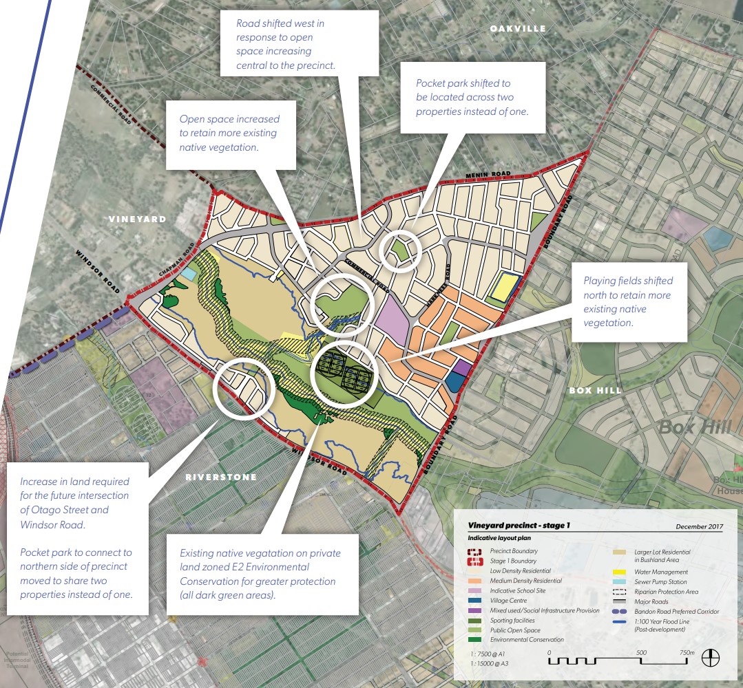
The rezoning of part of the Vineyard precinct will create a new community with shops, cafes and substantial green open space in Sydney's North West. Green spaces will be integrated with new homes with landscaping and tree planting along streets and in public domain areas, and with protected remnant stands of vegetation, for local residents to enjoy.
Suburb Summary
References
Vineyard – Stage 1 Precinct Rezoning
Hawkesbury City Council Growth Centres Precinct - Development Control Plan
NSW Planning (ePlanning Spatial Viewer)- Rezoned Area
Google Streetview and Aerial
Land Release Applications for 122-138 Menin Road, Oakville
| Land release | Land report | Number of lots | Plan number | Land surveyor | Lodged date | Intended use | Settlement tracking | |||||||||||||||||||||||||||||||||||||||||||||||||||||||||||||||||||||||||||||||||||||||||||
|---|---|---|---|---|---|---|---|---|---|---|---|---|---|---|---|---|---|---|---|---|---|---|---|---|---|---|---|---|---|---|---|---|---|---|---|---|---|---|---|---|---|---|---|---|---|---|---|---|---|---|---|---|---|---|---|---|---|---|---|---|---|---|---|---|---|---|---|---|---|---|---|---|---|---|---|---|---|---|---|---|---|---|---|---|---|---|---|---|---|---|---|---|---|---|---|---|---|---|
| No updates found |
Reviews & Comments on 122-138 Menin Road, Oakville
Estate Brochure, Masterplan, Engineering Plan, Plan of Subdivision (POS), Design Guidelines
FAQs about 122-138 Menin Road, Oakville
View all estates marketed by Century 21 Leading RE
- St Luke's Catholic College (Secondary) - 1.6km south-east
- Vineyard Public School - 2.4km west
- Oakville Public School - 2.6km north-west
- Arndell Anglican College - 3.8km north-west
- St John's Primary School - 3.9km south
- South Creek School - 4.0km south
Popular Estates near 122-138 Menin Road, Oakville
River Oaks Estate - Vineyard
Stockland The Gables - Gables
Trinity North West - Oakville
Parkside Estate - Box Hill
Redgum Rise Estate - Oakville
Penfolds Estate - Vineyard
One Fairway Estate - Pitt Town
Landen’s Oakville Estate - Oakville
Harkness Place Estate - Oakville
Latest New Home Articles for You

15/Apr/2024
Navigating the Intricacies of Nomination Blocks
In a recent episode of the Home Building Hub podcast, hosted by industry ...

10/Apr/2024
How Do Mortgages Work?
What is a mortgage broker? How does a mortgage broker get paid? Licensing...

10/Apr/2024
Victoria: Top 30 Most Searched Housing Developments (March 2024)
We're delighted to present the lineup of the top 30 most searched housing...

10/Apr/2024
Queensland: Top 30 Most Searched Housing Developments (March 2024)
In the radiant expanse of Australia's eastern coast lies Queensland, reno...

09/Apr/2024
South Australia: Top 30 Most Searched Housing Developments (March 2024)
South Australia, with its enchanting appeal and rich cultural heritage, e...

09/Apr/2024
New South Wales: Top 30 Most Searched Housing Developments (March 2024)
We have compiled the definitive list of the most sought-after housing dev...

09/Apr/2024
Western Australia: Top 30 Most Searched Housing Developments (March 2024)
If you've ever dreamed of calling Western Australia your home, now's the ...
![[Mar/2024] Top Most Searched Housing Developments in Australia](https://files.openlot.com.au/p/styles/500h/s3/article/Thumbnail%20-%20Top%2030%20Most%20Searched%20Housing%20Developments-5.jpg.webp?itok=yt0VccIK)
08/Apr/2024
[Mar/2024] Top Most Searched Housing Developments in Australia
In March 2024, OpenLot unveils a comprehensive showcase of the top-perfor...

02/Apr/2024
What is a house and land package? ...and are they exclusive?
House and land packages in new home construction, emphasising flexibility...