


Bloomfield Warragul Estate - Nilma COMING SOON
 41 Bloomfield Road, Nilma VIC 3821
- Half acre lots coming soon
- Build your dream home in Nilma
- Nestled just outside Warragul’s east, Bloomfield Estate is an exclusive new community that will elevate your lifestyle.
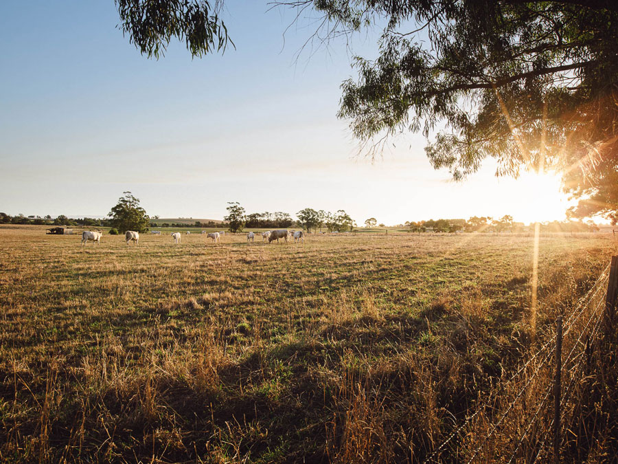
- Location: Against a backdrop of rolling hills and country lanes, yet only five minutes’ drive from bustling Warragul, Nilma is a place of wonderful contrasts and exceptional opportunities.
- Our Vision: It’s time to step out, embrace the new, and not just dream about what’s possible, but truly live it. And the perfect place to do that, is Bloomfield Estate… at the gateway to the magnificent Gippsland.
An idyllic setting extending from the gentle Hazel Creek, this is an address that lets you stretch out as you wish on genuinely spacious blocks, while staying easily connected to everything your modern lifestyle desires.
This information is estimated by the OpenLot research team. Let us know here to provide up-to-date information about this development.
| Total new homes | 94 |
| Area size | 39.19 hectares |
| Growth Region | Gippsland Regional Growth Areas |
| City council | Baw Baw Shire Council |
| Developer | Landcore |
| Project marketer | KaiKura Land Sales |
| Distance to | Melbourne CBD - 97 km south-east |
Land for Sale, House and Land Packages:
Popular Estates near Bloomfield Warragul Estate - Nilma

Lillifield Estate - Warragul

Drouin Fields Estate - Drouin

Binbeal Fields - Drouin

Ferntree Ridge Estate - Drouin

409 Copelands Road, Warragul VIC 3820

Emberwood Estate - Warragul

Waterford Rise Estate - Warragul

Crownlea Estate - Warragul

130 Dollarburn Road, Warragul VIC 3820
Updates for Bloomfield Warragul Estate - Nilma
Location & Map for Bloomfield Warragul Estate - Nilma
Schools near Bloomfield Warragul Estate - Nilma
Here are 6 schools near Bloomfield Warragul Estate - Nilma:
Prep-6 Government Primary School
Prep-6 Catholic Primary School
Prep-6 Government Primary School
Prep-6 Government Primary School
Prep-6 Government Primary School
Prep-12 Independent Combined School - School Head Campus
Land Release Applications for Bloomfield Warragul Estate - Nilma
| Land release | Land report | Number of lots | Plan number | Land surveyor | Lodged date | Intended use | Settlement tracking |
|---|---|---|---|---|---|---|---|
| 41 Bloomfield Road, Nilma VIC 3821 | BP003910G, AA-0305 | Lyssna Group Pty Ltd | Registered at Land Use Victoria | ||||
| BLOOMFIELD ESTATE - 1 | 41 Bloomfield Road, Nilma VIC 3821 | 22 | PS910359D, AA-0305, PLA0172/19, PSB0073/22, Stage 1 | Lyssna Group Pty Ltd | 13/09/2022 | Referral | |
| 41 Bloomfield Road, Nilma VIC 3821 | 95 | , 2102366, PLA0172/19, AMD0002/22 | Beveridge Williams & Co Pty Ltd | 27/01/2022 | - Changes the layout from 94 to 95 lots; - Change the entrance to the subdivision from Bloomfields Road to the south as per discussions and agreement with DPT; - Removes a pump station no longer required to service the development; - Restructures lot boundaries with the subdivision; and - Makes minor changes to the staging boundaries to conform with varied lot layout. - deletes condition 1p) | Final Referral Response (Permit) | |
| Jefford, Nilma | 41 Bloomfield Road, Nilma VIC 3821 | 86 | , 13021, PLA0172/19 | Planning Central | 19/08/2019 | Subdivision of land pursuant to the PSP (Low density residential and industrial) | Planning Permit |
Reviews & Comments on Bloomfield Warragul Estate - Nilma
Estate Brochure, Masterplan, Engineering Plan, Plan of Subdivision (POS), Design Guidelines
FAQs about Bloomfield Warragul Estate - Nilma
View all estates from Landcore
View all estates marketed by KaiKura Land Sales
- Nilma Primary School - 253m south-east
- St Angela of the Cross Primary School - 2.6km north
- Warragul North Primary School - 3.4km north-west
- Darnum Primary School - 3.6km south-east
- Warragul Primary School - 4.0km west
- St Paul's Anglican Grammar School - 4.1km north-west
Popular Estates near Bloomfield Warragul Estate - Nilma
Lillifield Estate - Warragul
Drouin Fields Estate - Drouin
Binbeal Fields - Drouin
Ferntree Ridge Estate - Drouin
409 Copelands Road, Warragul VIC 3820
Emberwood Estate - Warragul
Waterford Rise Estate - Warragul
Crownlea Estate - Warragul
130 Dollarburn Road, Warragul VIC 3820
Latest New Home Articles for You

15/Apr/2024
Navigating the Intricacies of Nomination Blocks
In a recent episode of the Home Building Hub podcast, hosted by industry ...

10/Apr/2024
How Do Mortgages Work?
What is a mortgage broker? How does a mortgage broker get paid? Licensing...

10/Apr/2024
Victoria: Top 30 Most Searched Housing Developments (March 2024)
We're delighted to present the lineup of the top 30 most searched housing...

10/Apr/2024
Queensland: Top 30 Most Searched Housing Developments (March 2024)
In the radiant expanse of Australia's eastern coast lies Queensland, reno...

09/Apr/2024
South Australia: Top 30 Most Searched Housing Developments (March 2024)
South Australia, with its enchanting appeal and rich cultural heritage, e...

09/Apr/2024
New South Wales: Top 30 Most Searched Housing Developments (March 2024)
We have compiled the definitive list of the most sought-after housing dev...

09/Apr/2024
Western Australia: Top 30 Most Searched Housing Developments (March 2024)
If you've ever dreamed of calling Western Australia your home, now's the ...
![[Mar/2024] Top Most Searched Housing Developments in Australia](https://files.openlot.com.au/p/styles/500h/s3/article/Thumbnail%20-%20Top%2030%20Most%20Searched%20Housing%20Developments-5.jpg.webp?itok=yt0VccIK)
08/Apr/2024
[Mar/2024] Top Most Searched Housing Developments in Australia
In March 2024, OpenLot unveils a comprehensive showcase of the top-perfor...

02/Apr/2024
What is a house and land package? ...and are they exclusive?
House and land packages in new home construction, emphasising flexibility...