
581-587 Mount Petrie Road, Mackenzie QLD 4156 COMING SOON
This information is estimated by the OpenLot research team. Let us know here to provide up-to-date information about this development.
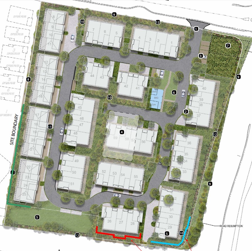
| Total new homes | 59 |
| Area size | 1.55 hectares |
| Growth Region | Greater Brisbane Growth Areas |
| City council | Brisbane City Council |
| Developer | N/A |
| Distance to | Brisbane CBD - 13 km south-east Brisbane Airport - 17 km south |
Townhomes:
Popular Estates near 581-587 Mount Petrie Road, Mackenzie

Monarch Estate - Rochedale

Arise Estate - Rochedale

The Pinnacle Arise Estate - Rochedale

58 West Street, Rochedale QLD 4123

Parkland at Rochedale Estate - Rochedale

Le Lux Townhomes - Rochedale

260 Priestdale Road, Rochedale QLD 4123

68 Woodcarver Street, Rochedale QLD 4123

29 Glenmore Crescent, Rochedale QLD 4123
Updates for 581-587 Mount Petrie Road, Mackenzie
Facebook updates:
Submit the Facebook page for 581-587 Mount Petrie Road, Mackenzie.
Related news:
The development application has been lodged for Multiple Dwellings, located at 581 & 587 Mount Petrie Road, Taylor Place and Mount Gravatt – Capalaba Road

581 & 587 Mount Petrie Road, MacKenzie, Qld 4156. View property details and sold price of 581 & 587 Mount Petrie Road & other properties in MacKenzie, Qld 4156.

Missing articles? Send us a link here.
Location & Map for 581-587 Mount Petrie Road, Mackenzie
Vacancy Rate in Mackenzie QLD 4156
View full vacancy rate history in Mackenzie QLD 4156 via SQM Research.
Schools near 581-587 Mount Petrie Road, Mackenzie
Here are 6 schools near 581-587 Mount Petrie Road, Mackenzie:
Prep-6 Government Primary School
Prep-12 Government Special School
Prep-12 Independent Combined School
7-12 Government Secondary School
Prep-6 Government Primary School
Prep-12 Independent Combined School
Land Release Applications for 581-587 Mount Petrie Road, Mackenzie
| Land release | Land report | Number of lots | Plan number | Land surveyor | Lodged date | Intended use | Settlement tracking | |||||||||||||||||||||||||||||||||||||||||||||||||||||||||||||||||||||||||||||||||||||||||||
|---|---|---|---|---|---|---|---|---|---|---|---|---|---|---|---|---|---|---|---|---|---|---|---|---|---|---|---|---|---|---|---|---|---|---|---|---|---|---|---|---|---|---|---|---|---|---|---|---|---|---|---|---|---|---|---|---|---|---|---|---|---|---|---|---|---|---|---|---|---|---|---|---|---|---|---|---|---|---|---|---|---|---|---|---|---|---|---|---|---|---|---|---|---|---|---|---|---|---|
| No updates found |
Reviews & Comments on 581-587 Mount Petrie Road, Mackenzie
Estate Brochure, Masterplan, Engineering Plan, Plan of Subdivision (POS), Design Guidelines
FAQs about 581-587 Mount Petrie Road, Mackenzie
- Mackenzie State Primary School - 236m east
- Mackenzie State Special School - 236m east
- Citipointe Christian College - 1.3km north-west
- Mansfield State High School - 1.4km west
- Mansfield State School - 1.5km west
- Brisbane Adventist College - 2.2km west
Popular Estates near 581-587 Mount Petrie Road, Mackenzie
Monarch Estate - Rochedale
Arise Estate - Rochedale
The Pinnacle Arise Estate - Rochedale
58 West Street, Rochedale QLD 4123
Parkland at Rochedale Estate - Rochedale
Le Lux Townhomes - Rochedale
260 Priestdale Road, Rochedale QLD 4123
68 Woodcarver Street, Rochedale QLD 4123
29 Glenmore Crescent, Rochedale QLD 4123
Latest New Home Articles for You

15/Apr/2024
Navigating the Intricacies of Nomination Blocks
In a recent episode of the Home Building Hub podcast, hosted by industry ...

10/Apr/2024
How Do Mortgages Work?
What is a mortgage broker? How does a mortgage broker get paid? Licensing...

10/Apr/2024
Victoria: Top 30 Most Searched Housing Developments (March 2024)
We're delighted to present the lineup of the top 30 most searched housing...

10/Apr/2024
Queensland: Top 30 Most Searched Housing Developments (March 2024)
In the radiant expanse of Australia's eastern coast lies Queensland, reno...

09/Apr/2024
South Australia: Top 30 Most Searched Housing Developments (March 2024)
South Australia, with its enchanting appeal and rich cultural heritage, e...

09/Apr/2024
New South Wales: Top 30 Most Searched Housing Developments (March 2024)
We have compiled the definitive list of the most sought-after housing dev...

09/Apr/2024
Western Australia: Top 30 Most Searched Housing Developments (March 2024)
If you've ever dreamed of calling Western Australia your home, now's the ...
![[Mar/2024] Top Most Searched Housing Developments in Australia](https://files.openlot.com.au/p/styles/500h/s3/article/Thumbnail%20-%20Top%2030%20Most%20Searched%20Housing%20Developments-5.jpg.webp?itok=yt0VccIK)
08/Apr/2024
[Mar/2024] Top Most Searched Housing Developments in Australia
In March 2024, OpenLot unveils a comprehensive showcase of the top-perfor...

02/Apr/2024
What is a house and land package? ...and are they exclusive?
House and land packages in new home construction, emphasising flexibility...