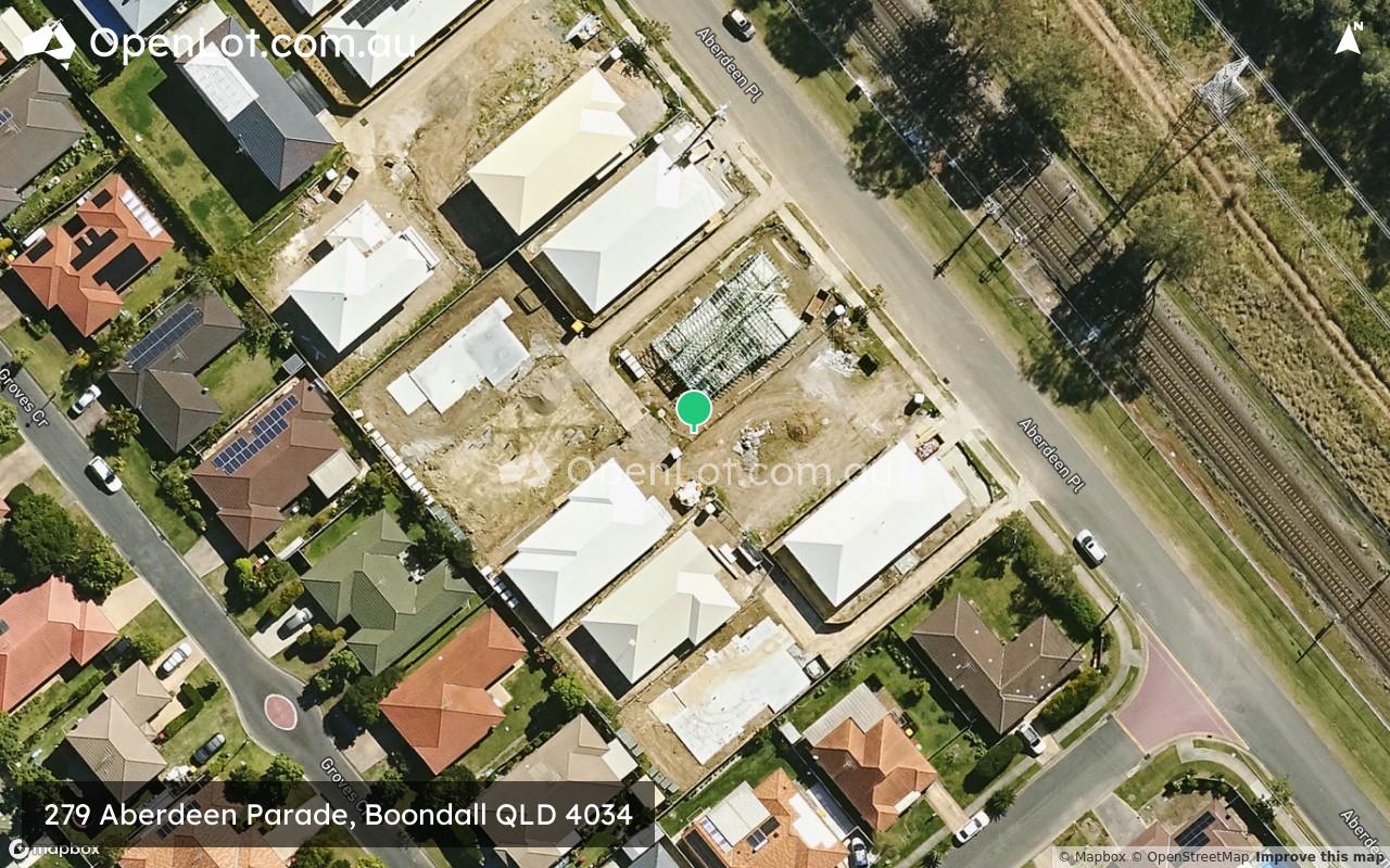
279 Aberdeen Parade, Boondall QLD 4034 SOLD OUT
[LIMITED OFFER] Welcome to Cordyline Grove
This information is estimated by the OpenLot research team. Let us know here to provide up-to-date information about this development.
| Total new homes | 9 |
| Area size | 0.40 hectares |
| Growth Region | Greater Brisbane Growth Areas |
| City council | Brisbane City Council |
| Developer | N/A |
| Project marketer | B.E Property |
| Distance to | Brisbane Airport - 7 km north-west Brisbane CBD - 14 km north |
Land for Sale:
9 Land Lots in 279 Aberdeen Parade - Boondall
Popular Estates near 279 Aberdeen Parade, Boondall


Updates for 279 Aberdeen Parade, Boondall
Facebook updates:
Related news:

Missing articles? Send us a link here.
Location & Map for 279 Aberdeen Parade, Boondall
Visit Display Homes near 279 Aberdeen Parade, Boondall


Vacancy Rate in Boondall QLD 4034
View full vacancy rate history in Boondall QLD 4034 via SQM Research.
Schools near 279 Aberdeen Parade, Boondall
Here are 6 schools near 279 Aberdeen Parade, Boondall:
Prep-6 Government Primary School
5-12 Catholic Combined School
Prep-6 Catholic Primary School
7-12 Government Secondary School
Prep-6 Government Primary School
Prep-6 Government Primary School
Reviews & Comments on 279 Aberdeen Parade, Boondall
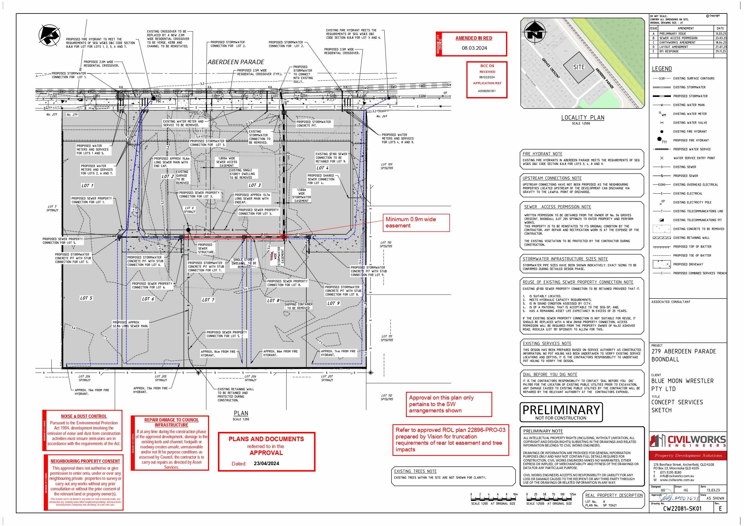
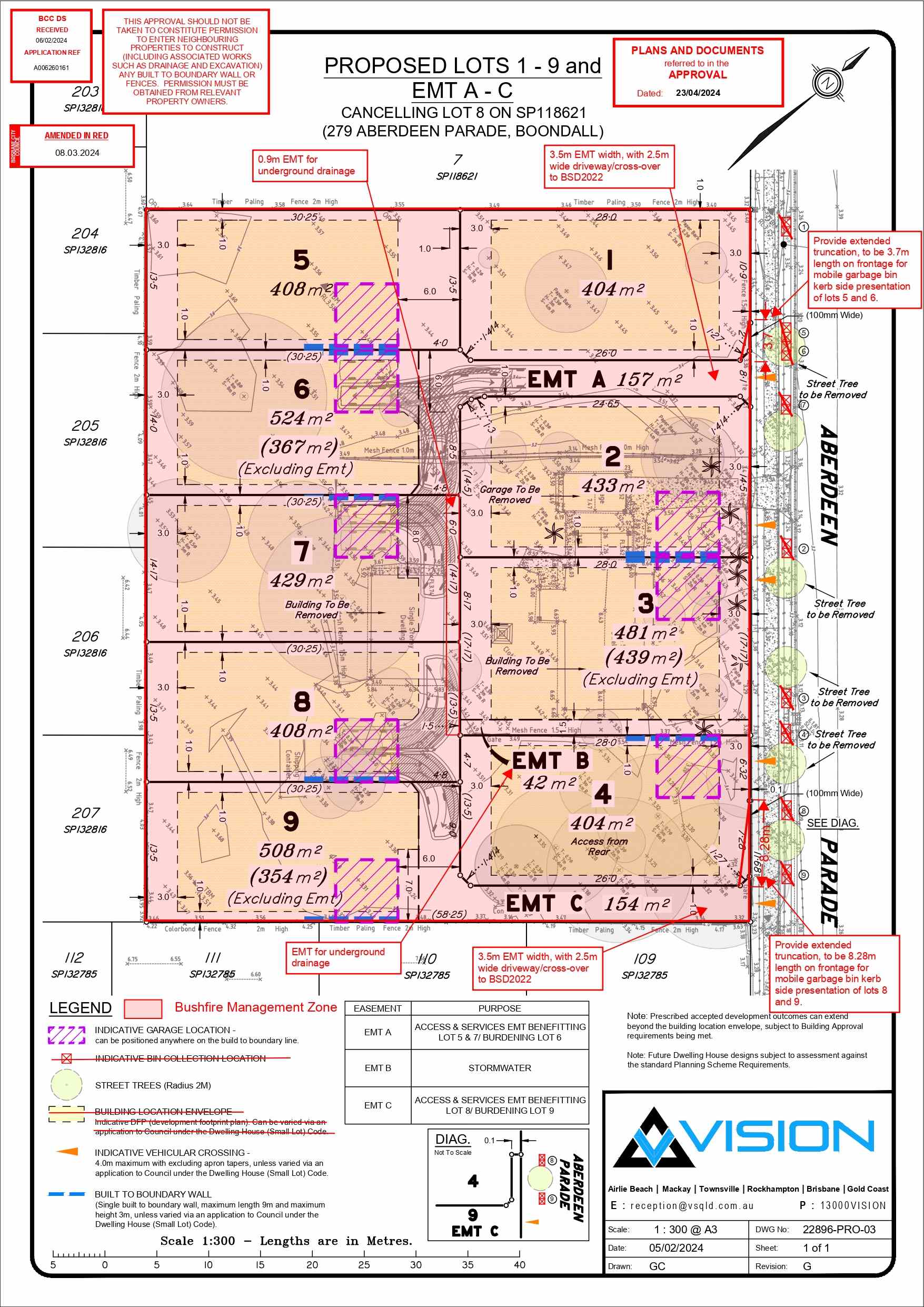
Estate Brochure, Masterplan, Engineering Plan, Plan of Subdivision (POS), Design Guidelines
FAQs about 279 Aberdeen Parade, Boondall
View all estates marketed by B.E Property
- Boondall State School - 1.2km west
- St Joseph's Nudgee College - 1.3km south-west
- St Pius' Primary School - 2.5km south-east
- Sandgate District State High School - 2.7km north-west
- Taigum State School - 3.1km west
- Shorncliffe State School - 3.1km north
Popular Estates near 279 Aberdeen Parade, Boondall
Latest New Home Articles for You

27/Jan/2026 | OpenLot.com.au
Display Homes at Stockland Wildflower Estate: A Smart Community in Piara Waters
Welcome to Wildflower, a vibrant new neighbourhood nestled in the heart o...

16/Jan/2026 | OpenLot.com.au
South Australia Top 30 Most Searched Housing Developments (December 2025)

15/Jan/2026 | OpenLot.com.au
Queensland: Top 30 Most Searched Housing Developments (December 2025)
If you’ve been tracking housing demand across Queensland, December 2025 p...

14/Jan/2026 | OpenLot.com.au
Victoria: Top 30 Most Searched Housing Developments (December 2025)
If you’ve been exploring housing opportunities in Victoria, December 2025...

14/Jan/2026 | OpenLot.com.au
Display Homes at Apsley Estate: A Masterplanned Community in Mandogalup
Apsley is a bold, 1,800-lot masterplanned community just 25 minutes south...

13/Jan/2026 | OpenLot.com.au
Western Australia: Top 30 Most Searched Housing Developments (December 2025)
If you’ve been keeping an eye on housing demand across Western Australia,...

12/Jan/2026 | OpenLot.com.au
New South Wales: Top 30 Most Searched Housing Developments (December 2025)
If you’ve been considering making a move in New South Wales, December 202...

07/Jan/2026 | OpenLot.com.au
🏡 Top 30 Most Searched Estates by State - December

06/Jan/2026 | OpenLot.com.au
Display Homes Near Me (WA): Your Complete Guide to Display Villages Across Western Australia
Finding the right display home in Western Australia has never been easier...