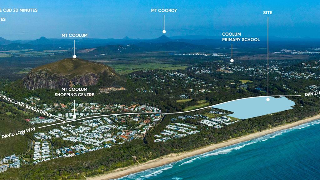
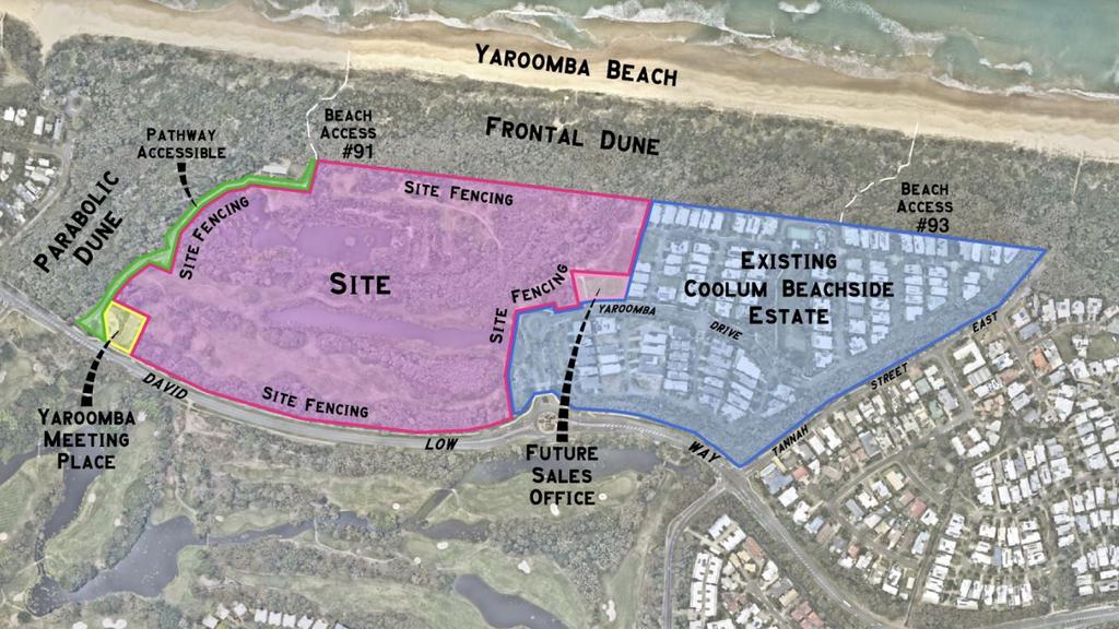

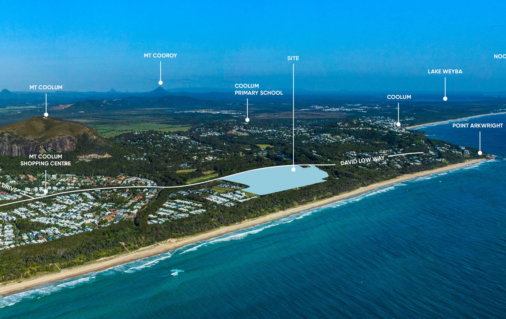
1415 David Low Way, Yaroomba QLD 4573 COMING SOON
This information is estimated by the OpenLot research team. Let us know here to provide up-to-date information about this development.
| Total new homes | N/A |
| Area size | 18.50 hectares |
| Growth Region | Sunshine Coast Growth Areas |
| City council | Sunshine Coast Council |
| Developer | Dennis Family Corporation |
| Distance to | Sunshine Coast - 11 km north |
Land for Sale, House and Land Packages:
Popular Estates near 1415 David Low Way, Yaroomba


 4
4  2.5
2.5  2
2
Updates for 1415 David Low Way, Yaroomba
Facebook updates:
Related news:
No Cookies
No Cookies
No Cookies
Prime beachside land that was previously earmarked for a luxury resort is set be offered to the market within months. Developer the Dennis Family Corporation (DFC) has confirmed that land within the planned gated community on the 18.5ha site at Yaroomba will be released mid-year. It comes after the company purchased the land from another […]
Missing articles? Send us a link here.
Location & Map for 1415 David Low Way, Yaroomba
Vacancy Rate in Yaroomba QLD 4573
View full vacancy rate history in Yaroomba QLD 4573 via SQM Research.
Schools near 1415 David Low Way, Yaroomba
Here are 6 schools near 1415 David Low Way, Yaroomba:
Prep-6 Government Primary School
Prep-12 Independent Combined School
7-12 Government Secondary School
Prep-6 Government Primary School
Prep-6 Government Primary School
Prep-12 Independent Combined School
Reviews & Comments on 1415 David Low Way, Yaroomba
Estate Brochure, Masterplan, Engineering Plan, Plan of Subdivision (POS), Design Guidelines
FAQs about 1415 David Low Way, Yaroomba
View all estates from Dennis Family Corporation
- Coolum State School - 3.1km north-west
- Coolum Beach Christian College - 5.6km north-west
- Coolum State High School - 6.3km north
- Pacific Paradise State School - 6.6km south
- Peregian Springs State School - 6.9km north-west
- St Andrew's Anglican College - 7.2km north
Popular Estates near 1415 David Low Way, Yaroomba
Latest New Home Articles for You

26/Jul/2024
Your next Investment Property Can Now Return 10%+
Find out How A ‘Multi-Liv’ Property Returns on Average $7,350 per mont...

26/Jul/2024
Deciphering the Tactics Behind Builder Promotions for Informed Decision-Making
In the labyrinthine world of home building, the allure of promotions can ...

18/Jul/2024
Display Homes at Ferntree Ridge: Embrace Country Living in Drouin
Ferntree Ridge by LandGipps, offers a unique opportunity to experience th...

15/Jul/2024
How to Finance Your House and Land Package
Financing a house and land package involves understanding various options...

09/Jul/2024
Display Homes at Kinley Lilydale: A New Era of Living
Intrapac Property's latest development, Kinley, is set to transform Lilyd...

09/Jul/2024
Victoria: Top 30 Most Searched Housing Developments (June 2024)
We're excited to unveil the lineup of the top 30 most searched housing de...

09/Jul/2024
Western Australia: Top 30 Most Searched Housing Developments (June 2024)
If you've ever dreamt of making Western Australia your home, now is the p...

09/Jul/2024
South Australia: Top 30 Most Searched Housing Developments (June 2024)
South Australia, with its captivating allure and rich cultural heritage, ...

09/Jul/2024
Queensland: Top 30 Most Searched Housing Developments (June 2024)
On Australia's sun-kissed eastern coast lies Queensland, often referred t...