

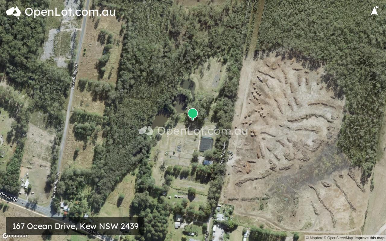
167 Ocean Drive, Kew NSW 2439 IN PLANNING
This information is estimated by the OpenLot research team. Let us know here to provide up-to-date information about this development.
| Total new homes | N/A |
| Area size | 15.85 hectares |
| City council | Port Macquarie-Hastings Council |
| Developer | N/A |
Land for Sale, House and Land Packages:
Popular Estates near 167 Ocean Drive, Kew


Updates for 167 Ocean Drive, Kew
Facebook updates:
Related news:
For Sale at 167 Ocean. Drive, Kew, NSW, 2439. View property details, features, photos, floor plans and more at Elders Real Estate!
The official Port Macquarie Council Application Tracker

The official Port Macquarie Council Application Tracker
Missing articles? Send us a link here.
Location & Map for 167 Ocean Drive, Kew
Schools near 167 Ocean Drive, Kew
Here are 6 schools near 167 Ocean Drive, Kew:
7-12 Government Secondary School
K-6 Government Primary School
K-6 Catholic Primary School
K-6 Government Primary School
K-6 Government Primary School
K-6 Government Primary School
Reviews & Comments on 167 Ocean Drive, Kew
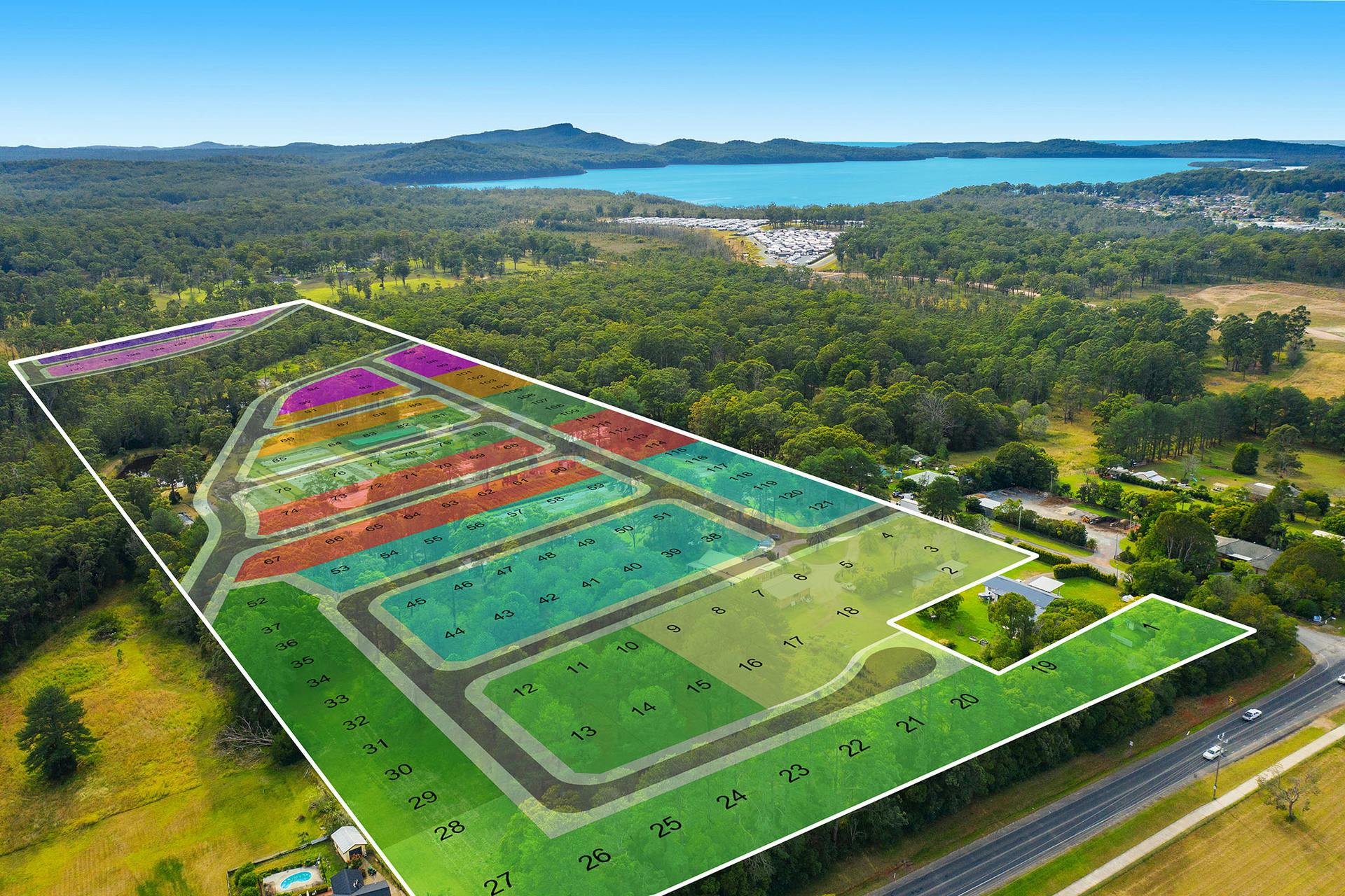
Estate Brochure, Masterplan, Engineering Plan, Plan of Subdivision (POS), Design Guidelines
FAQs about 167 Ocean Drive, Kew
- Camden Haven High School - 600m south-west
- Kendall Public School - 3.5km west
- St Joseph's Primary School - 5.1km east
- Laurieton Public School - 5.8km east
- Herons Creek Public School - 6.1km north
- North Haven Public School - 7.6km east
Popular Estates near 167 Ocean Drive, Kew
Latest New Home Articles for You

09/Mar/2026 | OpenLot.com.au
Victoria: Top 30 Most Searched Housing Developments (February 2026)
If you’ve been exploring housing opportunities in Victoria, February 2026...

20/Feb/2026 | OpenLot.com.au
Display Homes at Drouin Fields Estate: A Thriving Community in Drouin
Welcome to Drouin Fields, a place where beauty, space, and modern luxury ...

19/Feb/2026 | OpenLot.com.au
Display Homes at Manor Lakes Esate: A Thriving Waterside Community in Manor Lakes
A place where you can settle in, rather than just settle down. Named for ...

13/Feb/2026 | OpenLot.com.au
🏠 Victoria: Top 30 Most Searched Townhouse Developments – January 2026

11/Feb/2026 | OpenLot.com.au
🏡 Top 30 Most Searched Estates by State - January 2026

10/Feb/2026 | OpenLot.com.au
Victoria: Top 30 Most Searched Housing Developments (January 2026)
If you’ve been considering making a move in Victoria, January 2026 offere...

10/Feb/2026 | OpenLot.com.au
Queensland: Top 30 Most Searched Housing Developments (January 2026)
If you’ve been considering making a move in Queensland, January 2026 offe...

09/Feb/2026 | OpenLot.com.au
Western Australia: Top 30 Most Searched Housing Developments (January 2026)
If you’ve been considering making a move in Western Australia, January 20...

06/Feb/2026 | OpenLot.com.au
South Australia: Top 30 Most Searched Housing Developments (January 2026)
If you’ve been considering making a move in South Australia, January 2026...