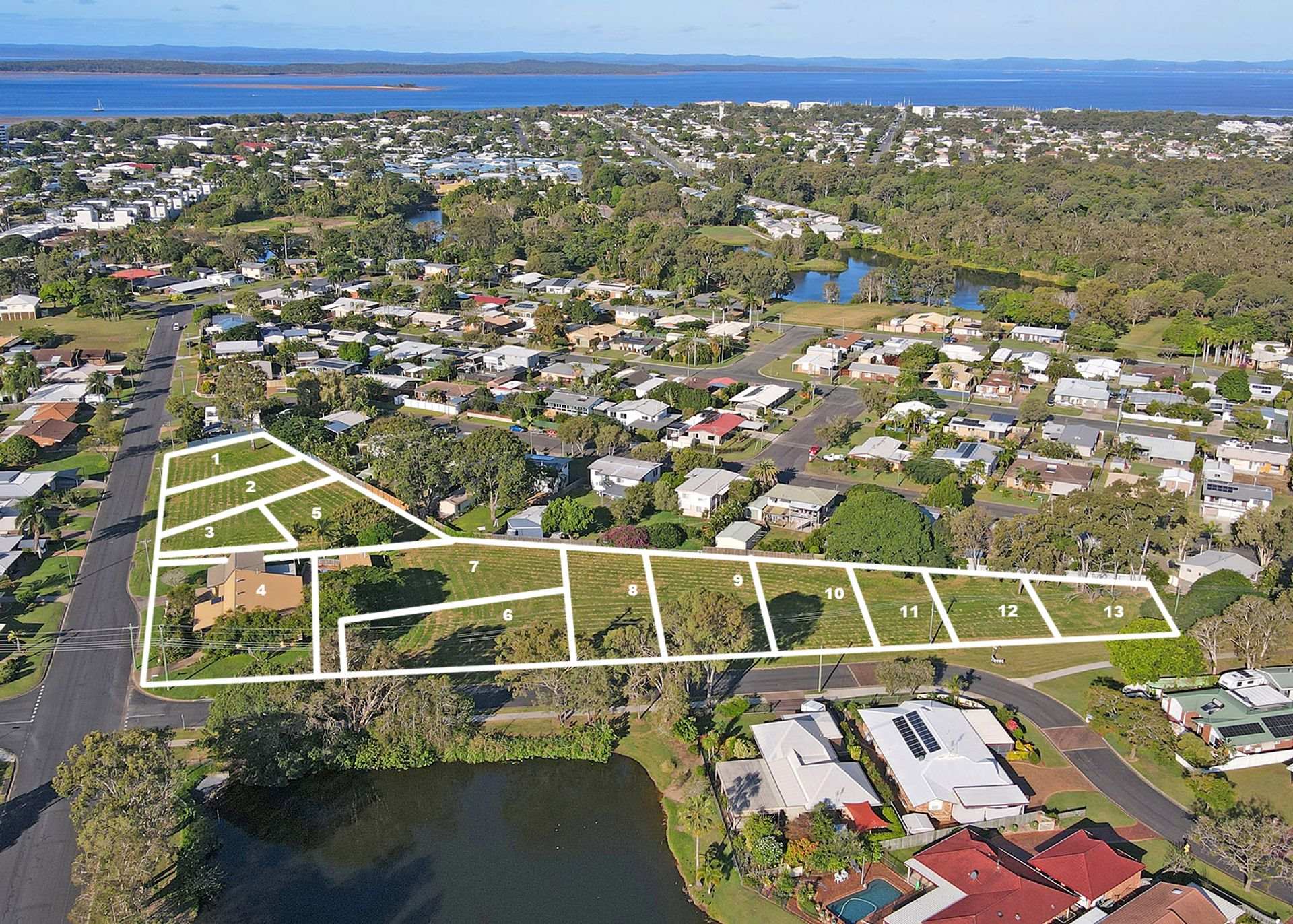

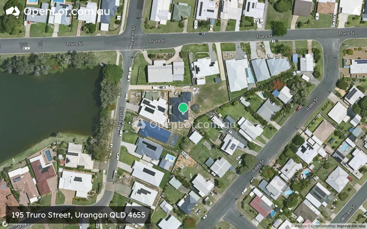
195 Truro Street, Urangan QLD 4655
This information is estimated by the OpenLot research team. Let us know here to provide up-to-date information about this development.
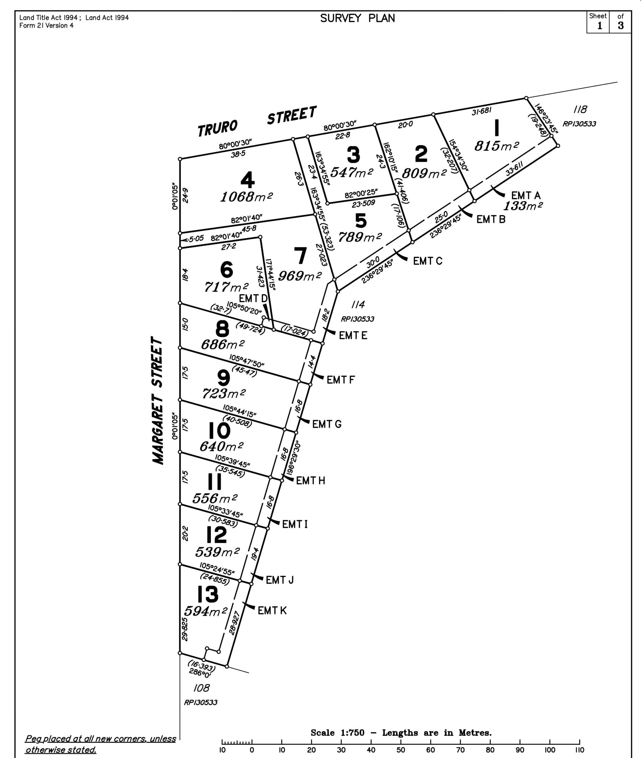
| Total new homes | 13 |
| Area size | 0.94 hectares |
| Growth Region | Hervey Bay (Wide Bay–Burnett Region) |
| City council | Fraser Coast Regional Council |
| Developer | N/A |
| Project marketer | Carter Cooper Realty |
Land for Sale, House and Land Packages:
Popular Estates near 195 Truro Street, Urangan


 4
4
 2
2
 2
2


Updates for 195 Truro Street, Urangan
Facebook updates:
Related news:
**** Site Works Now Underway ! Be quick as we there are only 2 blocks left!! *** 195 Truro Street, Urangan, is the latest beachside land release from an award-winning development team that has delivered a number of other quality developments across Southeast Queensland. Whether you are looking for a wonderfully located yet affordable block

Beachside Land - Exceptional Buying with a Desirable Lifestyle to Match! - 195 Truro Street, Urangan QLD 4655 - Vacant Land For Sale


Missing articles? Send us a link here.
Location & Map for 195 Truro Street, Urangan
Visit Display Homes near 195 Truro Street, Urangan

Vacancy Rate in Urangan QLD 4655
View full vacancy rate history in Urangan QLD 4655 via SQM Research.
Schools near 195 Truro Street, Urangan
Here are 6 schools near 195 Truro Street, Urangan:
Prep-6 Government Primary School
7-12 Government Secondary School
Prep-6 Government Primary School
Prep-6 Government Primary School
Prep-6 Catholic Primary School
Prep-12 Government Special School
Reviews & Comments on 195 Truro Street, Urangan
Estate Brochure, Masterplan, Engineering Plan, Plan of Subdivision (POS), Design Guidelines
FAQs about 195 Truro Street, Urangan
View all estates marketed by Carter Cooper Realty
- Urangan Point State School - 1.3km south-east
- Urangan State High School - 1.9km south-west
- Sandy Strait State School - 2.3km south-west
- Torquay State School - 2.6km west
- Star of the Sea Catholic School - 2.9km south-west
- Hervey Bay Special School - 4.0km west
Popular Estates near 195 Truro Street, Urangan
Latest New Home Articles for You

09/Mar/2026 | OpenLot.com.au
Victoria: Top 30 Most Searched Housing Developments (February 2026)
If you’ve been exploring housing opportunities in Victoria, February 2026...

20/Feb/2026 | OpenLot.com.au
Display Homes at Drouin Fields Estate: A Thriving Community in Drouin
Welcome to Drouin Fields, a place where beauty, space, and modern luxury ...

19/Feb/2026 | OpenLot.com.au
Display Homes at Manor Lakes Esate: A Thriving Waterside Community in Manor Lakes
A place where you can settle in, rather than just settle down. Named for ...

13/Feb/2026 | OpenLot.com.au
🏠 Victoria: Top 30 Most Searched Townhouse Developments – January 2026

11/Feb/2026 | OpenLot.com.au
🏡 Top 30 Most Searched Estates by State - January 2026

10/Feb/2026 | OpenLot.com.au
Victoria: Top 30 Most Searched Housing Developments (January 2026)
If you’ve been considering making a move in Victoria, January 2026 offere...

10/Feb/2026 | OpenLot.com.au
Queensland: Top 30 Most Searched Housing Developments (January 2026)
If you’ve been considering making a move in Queensland, January 2026 offe...

09/Feb/2026 | OpenLot.com.au
Western Australia: Top 30 Most Searched Housing Developments (January 2026)
If you’ve been considering making a move in Western Australia, January 20...

06/Feb/2026 | OpenLot.com.au
South Australia: Top 30 Most Searched Housing Developments (January 2026)
If you’ve been considering making a move in South Australia, January 2026...