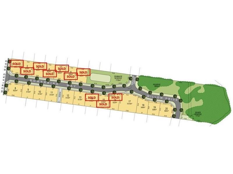

27-31 Worland Road, Wangaratta VIC 3677 SOLD OUT
This information is estimated by the OpenLot research team. Let us know here to provide up-to-date information about this development.
| Total new homes | 20 |
| Area size | 2.56 hectares |
| City council | Rural City Of Wangaratta |
| Developer | N/A |
Popular Estates near 27-31 Worland Road, Wangaratta


 4
4
 2
2
 2
2


Updates for 27-31 Worland Road, Wangaratta
Location & Map for 27-31 Worland Road, Wangaratta
Land Price Trend in Wangaratta VIC 3677
- In Oct - Dec 24, the median price for vacant land in Wangaratta VIC 3677 was $291,900. *
- From Oct - Dec 17 to Oct - Dec 24, the median price for vacant land in Wangaratta VIC 3677 has increased 93.95%. *
- From 2008 to 2024, the median price for vacant land in Wangaratta VIC 3677 has increased 231.61%. *
Vacancy Rate in Wangaratta VIC 3677
View full vacancy rate history in Wangaratta VIC 3677 via SQM Research.
Schools near 27-31 Worland Road, Wangaratta
Here are 6 schools near 27-31 Worland Road, Wangaratta:
U Government Special School - School Head Campus
Prep-6 Government Primary School
Prep-6 Catholic Primary School
Prep-6 Government Primary School
7-12 Government Secondary School - School Head Campus
7-12 Catholic Special School
Reviews & Comments on 27-31 Worland Road, Wangaratta
Estate Brochure, Masterplan, Engineering Plan, Plan of Subdivision (POS), Design Guidelines
FAQs about 27-31 Worland Road, Wangaratta
- Wangaratta District Specialist School - 1.1km north-east
- Appin Park Primary School - 1.2km north-east
- St Bernard's School - 1.4km east
- Wangaratta West Primary School - 1.4km east
- Wangaratta High School - 1.8km east
- Borinya, Wangaratta Community Partnership - 2.1km north-east
Popular Estates near 27-31 Worland Road, Wangaratta
Latest New Home Articles for You

09/Mar/2026 | OpenLot.com.au
Victoria: Top 30 Most Searched Housing Developments (February 2026)
If you’ve been exploring housing opportunities in Victoria, February 2026...

20/Feb/2026 | OpenLot.com.au
Display Homes at Drouin Fields Estate: A Thriving Community in Drouin
Welcome to Drouin Fields, a place where beauty, space, and modern luxury ...

19/Feb/2026 | OpenLot.com.au
Display Homes at Manor Lakes Esate: A Thriving Waterside Community in Manor Lakes
A place where you can settle in, rather than just settle down. Named for ...

13/Feb/2026 | OpenLot.com.au
🏠 Victoria: Top 30 Most Searched Townhouse Developments – January 2026

11/Feb/2026 | OpenLot.com.au
🏡 Top 30 Most Searched Estates by State - January 2026

10/Feb/2026 | OpenLot.com.au
Victoria: Top 30 Most Searched Housing Developments (January 2026)
If you’ve been considering making a move in Victoria, January 2026 offere...

10/Feb/2026 | OpenLot.com.au
Queensland: Top 30 Most Searched Housing Developments (January 2026)
If you’ve been considering making a move in Queensland, January 2026 offe...

09/Feb/2026 | OpenLot.com.au
Western Australia: Top 30 Most Searched Housing Developments (January 2026)
If you’ve been considering making a move in Western Australia, January 20...

06/Feb/2026 | OpenLot.com.au
South Australia: Top 30 Most Searched Housing Developments (January 2026)
If you’ve been considering making a move in South Australia, January 2026...