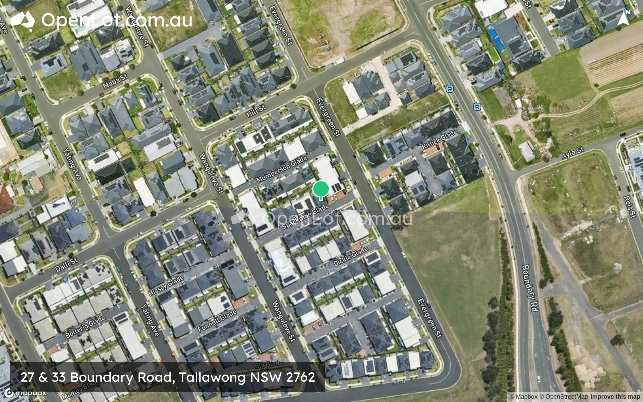
27 & 33 Boundary Road, Tallawong NSW 2762
This information is estimated by the OpenLot research team. Let us know here to provide up-to-date information about this development.
| Total new homes | N/A |
| Area size | N/A |
| Growth Region | Sydney North West Growth Areas |
| City council | Blacktown City Council |
| Developer | The Bathla Group |
| Distance to | Sydney CBD - 34 km north-west Sydney Airport - 39 km north-west |
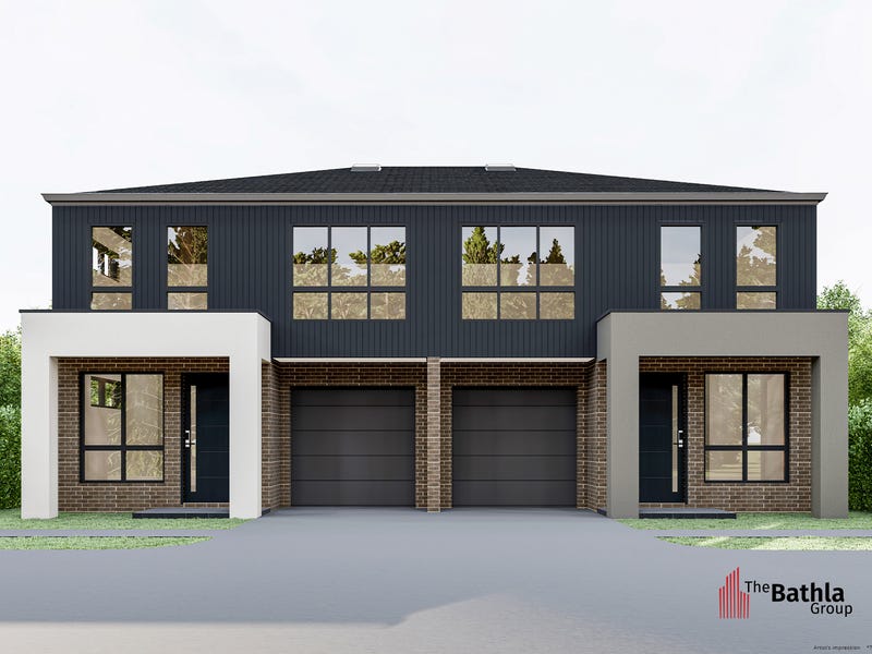
Townhomes:
Popular Estates near 27 & 33 Boundary Road, Tallawong


 4
4
 2
2
 1
1


Updates for 27 & 33 Boundary Road, Tallawong
Facebook updates:
Submit the Facebook page for 27 & 33 Boundary Road, Tallawong.
Related news:
4 bedroom townhouse for sale at B10/27 Boundary Road, Schofields, NSW 2762, Contact Agent. View 13 property photos, floor plans and Schofields suburb information.
4 bedroom off the plan house for Sale at Unit 14/27 Boundary RD, Tallawong, Schofields NSW 2762. View property photos, floor plans, local school catchments & lots more on Domain.com.au. 2016967801

Missing articles? Send us a link here.
Location & Map for 27 & 33 Boundary Road, Tallawong
Visit Display Homes near 27 & 33 Boundary Road, Tallawong


Vacancy Rate in Tallawong NSW 2762
View full vacancy rate history in Tallawong NSW 2762 via SQM Research.
Schools near 27 & 33 Boundary Road, Tallawong
Here are 6 schools near 27 & 33 Boundary Road, Tallawong:
K-6 Government Primary School
K-6 Government Primary School
K-6 Catholic Primary School
7-12 Catholic Secondary School - School Head Campus
7-12 Government Secondary School
K-6 Government Primary School
Reviews & Comments on 27 & 33 Boundary Road, Tallawong
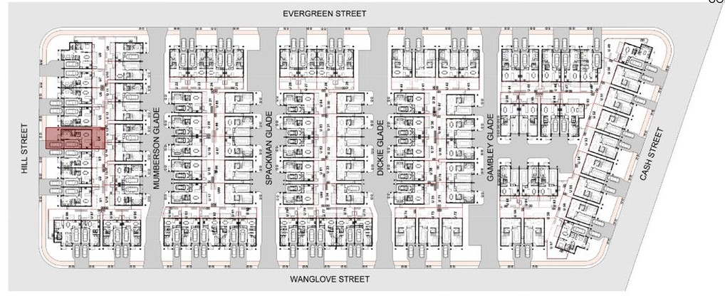
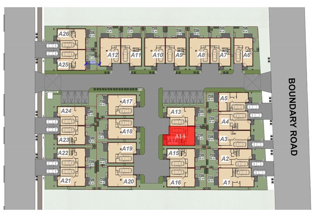
Estate Brochure, Masterplan, Engineering Plan, Plan of Subdivision (POS), Design Guidelines
FAQs about 27 & 33 Boundary Road, Tallawong
View all estates from The Bathla Group
- Galungara Public School - 724m south-west
- Schofields Public School - 992m west
- St Joseph's Primary School - 1.1km south
- St John Paul II Catholic College - 1.3km south-east
- The Ponds High School - 1.3km south-east
- Riverbank Public School - 1.6km south-east
Popular Estates near 27 & 33 Boundary Road, Tallawong
Latest New Home Articles for You

09/Mar/2026 | OpenLot.com.au
Victoria: Top 30 Most Searched Housing Developments (February 2026)
If you’ve been exploring housing opportunities in Victoria, February 2026...

20/Feb/2026 | OpenLot.com.au
Display Homes at Drouin Fields Estate: A Thriving Community in Drouin
Welcome to Drouin Fields, a place where beauty, space, and modern luxury ...

19/Feb/2026 | OpenLot.com.au
Display Homes at Manor Lakes Esate: A Thriving Waterside Community in Manor Lakes
A place where you can settle in, rather than just settle down. Named for ...

13/Feb/2026 | OpenLot.com.au
🏠 Victoria: Top 30 Most Searched Townhouse Developments – January 2026

11/Feb/2026 | OpenLot.com.au
🏡 Top 30 Most Searched Estates by State - January 2026

10/Feb/2026 | OpenLot.com.au
Victoria: Top 30 Most Searched Housing Developments (January 2026)
If you’ve been considering making a move in Victoria, January 2026 offere...

10/Feb/2026 | OpenLot.com.au
Queensland: Top 30 Most Searched Housing Developments (January 2026)
If you’ve been considering making a move in Queensland, January 2026 offe...

09/Feb/2026 | OpenLot.com.au
Western Australia: Top 30 Most Searched Housing Developments (January 2026)
If you’ve been considering making a move in Western Australia, January 20...

06/Feb/2026 | OpenLot.com.au
South Australia: Top 30 Most Searched Housing Developments (January 2026)
If you’ve been considering making a move in South Australia, January 2026...