


Alkimos is a local town of approximately 37.9 square kilometres in area, forming part of the northern coastal region of Perth that is located 40 kilometres south. The coastal township contains a northern urbanised area, local centres (commercial and retail), large residential areas, parks and schools. The urbanised area forms part of the City of Wanneroo local government area. For the most part, the suburb is covered in native banksia woodland, scrubland and heath typical of the Swan Coastal Plain.
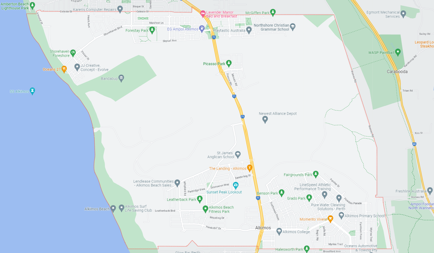
The suburb boundary is located along property boundaries to the south. The Neerabup National Park is the entire northern boundary, Romeo Road and property boundaries to the East and the Mitchell Freeway further east. The Indian Ocean provides the suburb boundary to the west.
A local road network is found throughout Alkimos, providing access to the surrounding suburbs and the local network of roads. Santorini Promenade and Hawksbill Drive provide west and east connections through the centre of the suburb, whilst Marmion Avenue provides north and south connections linking to the major arterial road in proximity.
The northern urban area contains residential areas, parks and schools, which is more related to the Amberton suburb as a largely undeveloped natural area separates the areas. The southern portion of the suburb provides a mix of zoning that facilitates the community’s needs and services. The neighbourhood zone exists to the south of the business, retail and commercial zoning and provides exiting residential areas of the suburb.

Alkimos is a relatively new suburb and has experienced rapid growth in recent years. The suburb's population is expected to continue to increase, with plans for new housing developments, schools, and community facilities in the works. The suburb currently has a number of schools, including Alkimos Primary School, Alkimos Beach Primary School, and St James' Anglican School, with plans for additional schools in the future.
Alkimos is a rapidly growing suburb located in the northern coastal region of Perth, Western Australia. It is designated as a "growth area" by the Western Australian Planning Commission due to its significant potential for future development and expansion.
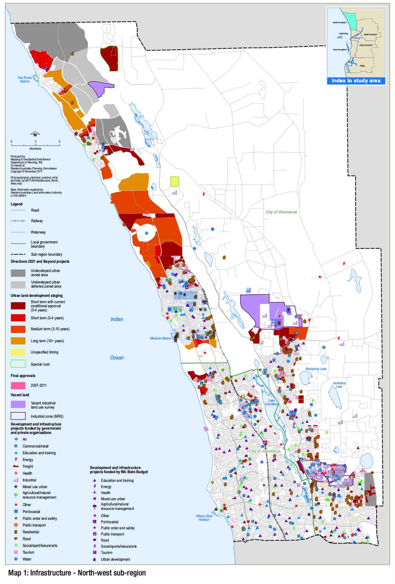
Northern Coastal Growth Corridor
The City of Wanneroo identified Alkimose within its Northern Coastal Growth Corridor Community Facilities Plan Review 2019-2029, dated 10 January 2020. This planning document provides a framework for the provision of community facilities in the northern coastal suburbs of Perth, and identifies the community's current and future needs and outlines strategies to provide the necessary facilities and services.
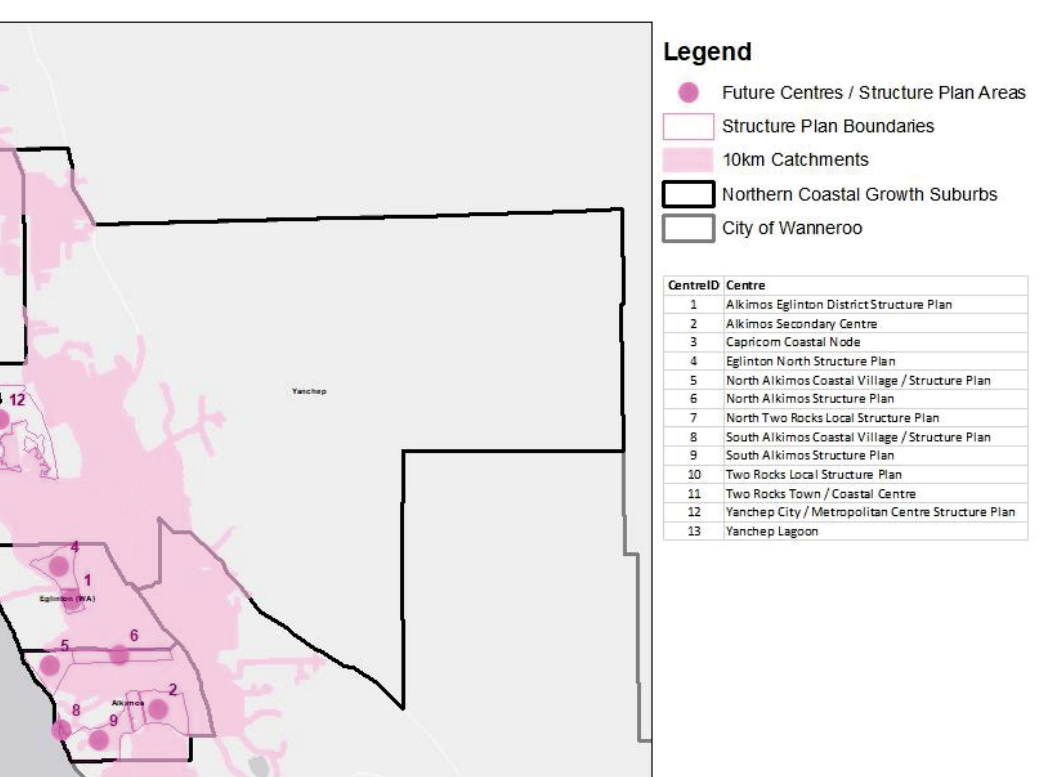
The Northern Coastal Growth Corridor Community Facilities Plan Review 2019-2029 is one of several plans that contribute to the implementation of the Wanneroo North-West District Structure Plan. It provides a more detailed focus on the provision of community facilities and services in the northern coastal suburbs, including Alkimos. Together, these plans help to guide the sustainable and coordinated development of the area, via the 5 significant growth area opportunities.
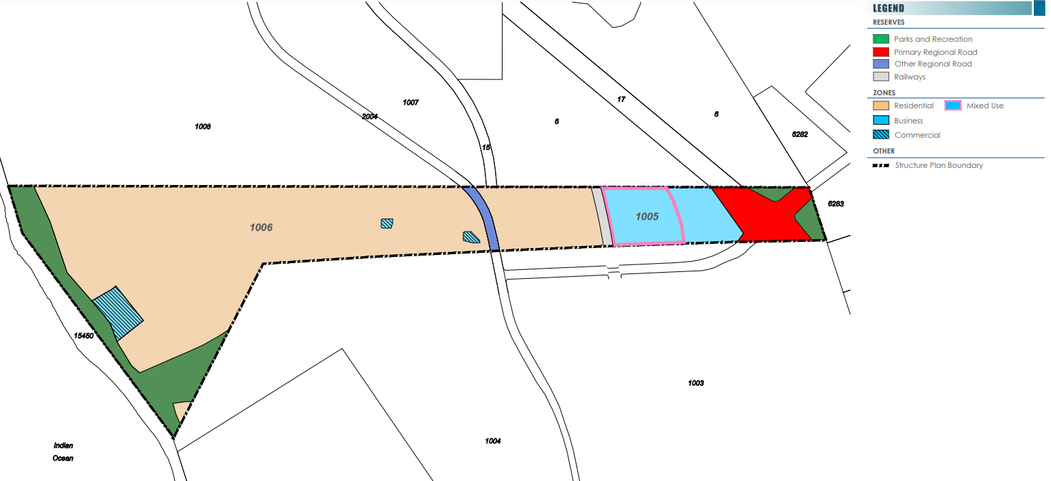
Alkimos (Second) Central LSP
The Alkimos Central Local Structure Plan (LSP) is a planning document that guides the development of a specific area within the suburb of Alkimos, Western Australia. The LSP provides guidance on land use, zoning, infrastructure, and environmental considerations for the area. The Alkimos Central LSP covers an area of approximately 85 hectares and includes provisions for a town centre, residential areas, and open spaces.
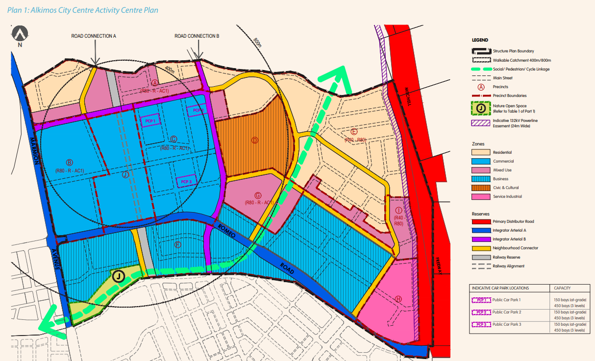
The Alkimos Secondary Centre Structure Plan is a planning document that outlines the proposed development of a secondary center in the suburb of Alkimos, located within the Northern Coastal Growth Corridor in Western Australia.
The Alkimos Secondary Centre is intended to be a mixed-use development that will serve as a hub for community services, commercial activities, and entertainment. It is envisioned as a pedestrian-friendly, high-quality urban center that will provide a range of facilities and services to the growing population of the Alkimos area.
The Alkimos Secondary Centre Structure Plan includes provisions for a range of facilities, including retail and commercial spaces, entertainment and leisure facilities, community and cultural amenities, and transport infrastructure. The plan also includes provisions for high-density residential development, with a mix of apartment buildings, townhouses, and single-family homes.
The Alkimos Central Local Structure Plan was approved by the Western Australian Planning Commission on August 30, 2018.
Alkimos Eglinton District Structure Plan
The Alkimos Eglinton District Structure Plan (DSP) is a planning document that provides a framework for the development and growth of the Alkimos and Eglinton areas, which are located in the northern coastal suburbs of Perth, Western Australia. The DSP was developed by the Western Australian Planning Commission (WAPC) in consultation with the City of Wanneroo and other stakeholders, and was first approved in 2006.
The Alkimos Eglinton District Structure Plan was approved by the Western Australian Planning Commission on 22 December 2011.
Alkimos Eglinton Local Structure Plan
The Alkimos Eglinton District Structure Plan is a planning document developed by the Western Australian Planning Commission that sets out the long-term land use and development vision for the Alkimos-Eglinton district. The plan was first released in 2009 and was updated in 2016. The plan covers an area of approximately 2,860 hectares and is located approximately 40 kilometers north of Perth's central business district. The Alkimos Eglinton District Structure Plan provides guidance for the provision of infrastructure, the location of future residential, commercial and industrial development, and the protection of natural and cultural assets in the area.
The Alkimos Eglinton District Structure Plan was approved by the Western Australian Planning Commission on 22 September 2009.
North Alkimos LSP
The North Alkimos Local Structure Plan is a planning document that provides a framework for the development of a specific area within the suburb of Alkimos. It outlines the vision and objectives for the area, as well as the land use and development guidelines that should be followed to achieve the desired outcomes. The plan includes details such as road networks, public transport options, open space and parkland provisions, and other infrastructure requirements to support the development of the area. The North Alkimos Local Structure Plan is part of the broader Wanneroo North-West District Structure Plan, which sets out the planning framework for the entire growth area.
The North Alkimos Local Structure Plan was approved by the Western Australian Planning Commission on August 23, 2011.
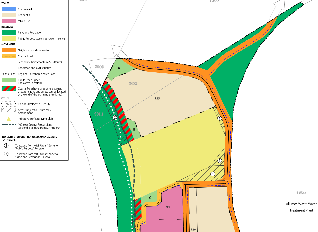
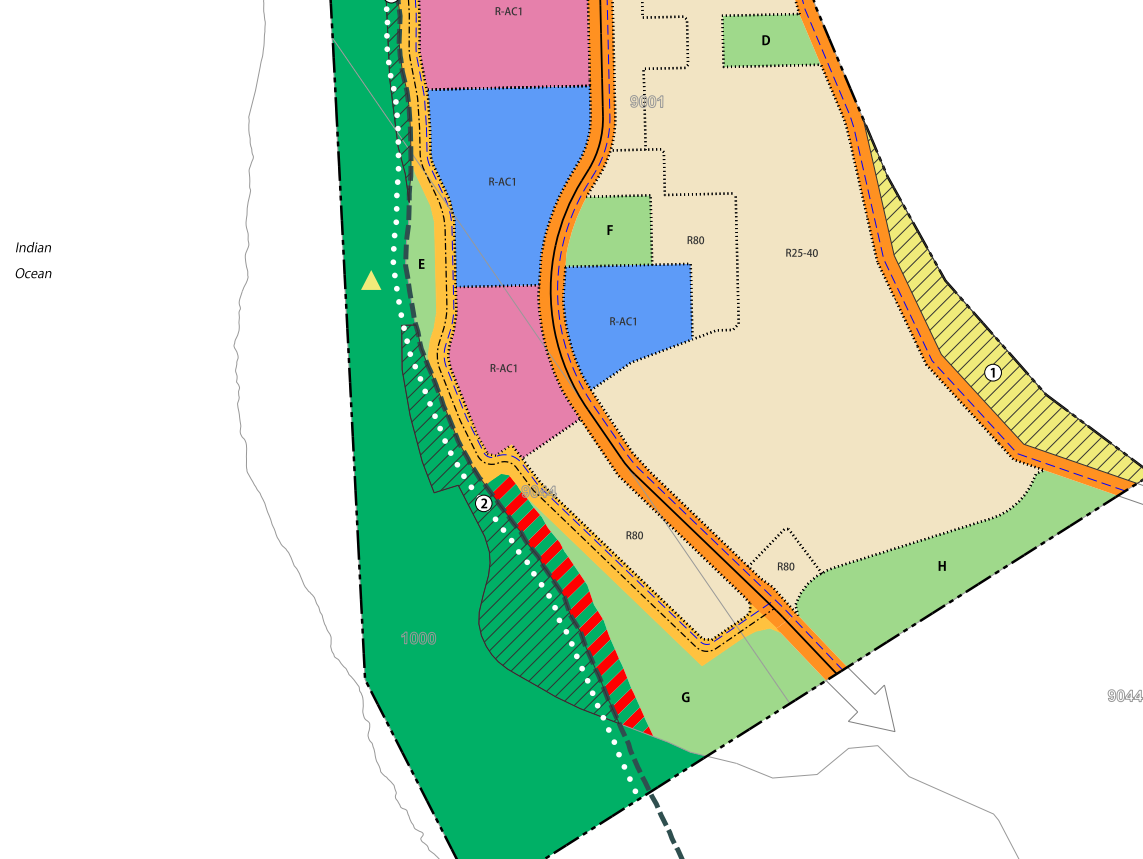
Alkimos Beach Local Structure Plan
The Alkimos Beach Local Structure Plan (LSP) is a planning document that provides a detailed framework for the development of the Alkimos Beach area in Western Australia. The LSP covers an area of approximately 710 hectares and outlines a range of planning and development guidelines, including land use and zoning, open space and conservation areas, transport and infrastructure, and urban design. The Alkimos Beach LSP was developed by the City of Wanneroo in collaboration with various government agencies and community stakeholders.
The Alkimos Beach Local Structure Plan was approved by the Western Australian Planning Commission on May 23, 2013.
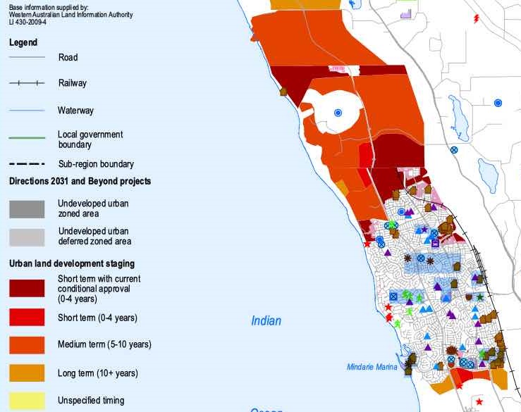
Wanneroo North-West District Structure Plan
The Wanneroo North-West District Structure Plan, which was approved by the Western Australian Planning Commission in 2004, established the framework for the development of the Wanneroo growth area, including the Alkimos area. This plan outlines the land use and development patterns, transportation, infrastructure, and environmental considerations for the area.
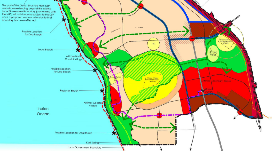
The Wanneroo North-West District Structure Plan aims to create a well-connected and sustainable community in Alkimos while preserving important natural features, public open space and conservation, including the Alkimos Regional Open Space and the Yanchep National Park. The open space is critical to providing for future density and growth.
This structure plan covers a large area, including Alkimos, and it outlines a framework for future development and land use within the district. Rezoning has occurred in several areas for different uses. Providing a new town centre that will include retail and commercial spaces as well as public amenities such as parks and community facilities. The plan also designates areas for residential development, including single-family homes, apartments, and townhouses.
The Western Australian Planning Commission released the vision for Wanneroo North-West District Structure Plan, as stated "The Wanneroo North-West District Structure Plan is a long-term vision that will guide the growth of the area over the next 30 years. It aims to create a sustainable, connected, and liveable community with a range of housing, employment, transport, and community facilities. The plan will provide for the conservation and protection of the area's natural environment, cultural heritage, and important landmarks while promoting economic growth and prosperity."
The Perth and Peel @ 3.5million
The frameworks aim to accommodate 3.5 million people by 2050 by creating vibrant communities within a compact and connected city; making best use of existing and proposed infrastructure; and protecting important environmental assets.
The framework encourages significantly greater infill development with almost half of the required 800,000 new homes – 380,000 at a minimum - to be built through infill development. The majority of these – around 214,000 – will be built in existing suburbs within the Central sub-region and particularly through alignment with the new METRONET rail project.
Western Australian Planning Commission produced the Wanneroo North-West District Structure Plan as part of the plan to facilitate the changes.
Alkimos Suburb Summary
References
- Alkimos – SA State Government
- Alkimos – Council Development and Planning Policies
- Alkimos Central Local Structure Plan
- Alkimos Eglinton District Structure Plan
- North Alkimos Local Structure Plan
- Alkimos Beach Local Structure Plan
- Alkimos – Perth and Peel @ 3.5 million - WA Planning Submission
- Google Streetview and Aerial