


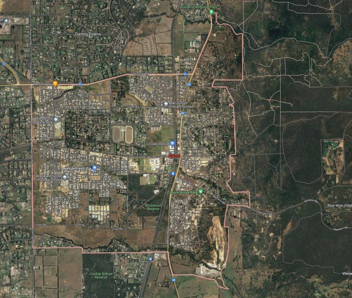
Byford is a suburb of approximately 22 square kilometres in area, forming part of the south-eastern regional urban fringe of Perth that is located 38 kilometres from the Perth CBD. The suburb is located inland near the base of the National Park located on the ridge of the Darling Range.
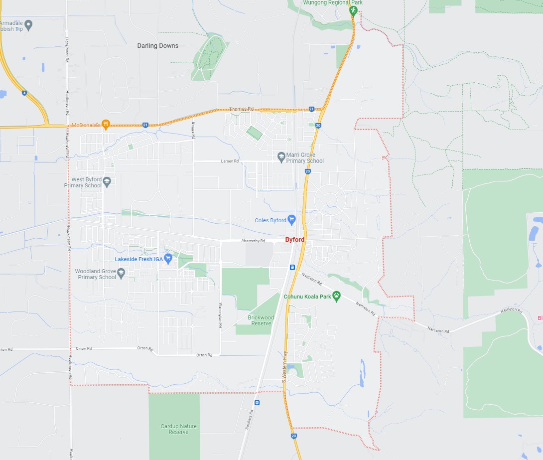
The suburb boundary is located along Cardup Siding Road and Kilin Road to the south, Thomas Road and Wungong Rover to the north, property boundaries make up the entire eastern boundary and Hopkinson Road provides the western boundary.
The South Western Highway and rail line corridor run parallel together through the suburb (north to south) separating the eastern portion of the area, with Abernethy Road providing local road access (east to west) and connecting both networks found throughout Byford. Orton Road to the south and Thomas Road to the north also provide east west connections to surrounding residential.
The town origins began as "Beenup" in 1906 and under a public ballot in 1920, the name of the township was changed to Byford. Highly influenced by brick making in the early 20th century and the construction of the South Western Railway reached the district in 1892, where a series of stations were built to only be demolished in the 1980-90s. The current Byford train station was built before the turn of the 21st Century and is proposed to be demolished, with a new station to be built as part of the Transperth's Armadale Line service.
In 1977, Byford was transferred from the Shire of Armadale-Kelmscott to the Shire of Serpentine-Jarrahdale and has now become an extension of the Perth metropolitan area, connected to the Kwinana Freeway by Thomas Road, and has experienced a substantial rise in population. The suburb had 3 creek corridors that traversed the site from east to west, linking to vegetated parks, open space and reserves.
The new subdivision "Byford on the Scarp" was completed in 2000 and in early 2010 "The Glades" located in the west of the suburb was developed winning three awards, including two national awards. The township forms part of the Shire of Serpentine-Jarrahdale local government area, containing a well established urbanised area, multiple local centres (commercial and retail), large residential areas, parks and schools throughout. The suburb fringe along the western southern boundaries contains the remaining rural farming land and is likely to be redeveloped for residential housing in the future.
Serpentine-Jarrahdale: Local Planning Strategy
The Local Planning Strategy stands as a pivotal document within the Shire of Serpentine Jarrahdale, securing an endorsement from the Western Australian Planning Commission on March 18, 2022. Operating as a visionary blueprint, this strategy delineates the trajectory of the Shire's development and growth across the ensuing decade. Designed as a comprehensive roadmap, it holds significant weight, dictating the landscape of land use, zoning regulations, and overall developmental provisions stipulated within the Local Planning Scheme.
Key Points:
- Serves as a guiding framework, wielding considerable influence over land use zoning and various provisions encapsulated within the Local Planning Scheme.
- Adopts an integrative approach, weaving together a tapestry of social, environmental, and economic considerations. It encapsulates the Shire's collective ambitions by meticulously outlining objectives, strategies, and actionable steps across critical spheres such as housing, employment, business vitality, transportation networks, community infrastructure, public spaces, and the sustainable management of environmental resources.
- Delving deeper than a simple projection of future developmental pathways, this Strategy captures the essence of the Shire's aspirations. It symbolizes a collaborative effort, drawing insights from diverse stakeholders, local residents, industry experts, and policymakers, reflecting a collective vision for a vibrant, sustainable, and prosperous future.
The Local Planning Strategy assumes a pivotal role in steering the trajectory of the Shire of Serpentine Jarrahdale over the next decade. It emerges not only as a regulatory document but as a manifestation of communal aspirations, serving as a roadmap charting the Shire's progress toward a balanced and sustainable future.
Draft Council Plan 2023 - 2033
The Shire of Serpentine Jarrahdale recently conducted a comprehensive review of its Strategic Community Plan, now rebranded as the 'Council Plan.' The 'Shape our Future - SJ 2033' engagement project, held in March and April 2023, aimed to gather ideas from all facets of the community to shape a visionary 10-year strategic plan for the Shire. Residents across age groups, including seniors, youth, families, sports groups, volunteers, and businesses, contributed to this effort, attending workshops, pop-up events, and surveys, resulting in over 600 responses.
The Draft Council Plan, a culmination of this extensive engagement, is available for public feedback until August 31, 2023. This plan encapsulates three pivotal themes that will shape the next decade in the Shire of Serpentine Jarrahdale: Thriving - focusing on sustainable growth and community support, Liveable - emphasizing the preservation of rural landscapes and access to essential services, and Connected - promoting vibrant neighbourhoods celebrating diversity and history.
Residents are encouraged to review the Draft Council Plan and share their thoughts before the consultation closes. This plan stands as a collective vision, aiming to steer the Shire towards a sustainable, flourishing future that encapsulates the aspirations and values of its diverse population.
The Shire of Serpentine Jarrahdale's future direction for the next decade revolves around three central themes:
- Thriving: Fostering sustainable growth, partnerships, and leadership to create a well-planned Shire that supports community flourishing.
- Liveable: Ensuring a protected, enhanced, and safe rural environment, both natural and built, while guaranteeing access to essential services and facilities.
- Connected: Cultivating vibrant, connected neighbourhoods that celebrate the area's history and diverse community, fostering a sense of togetherness and inclusivity.
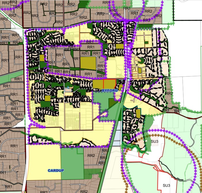
Byford Local Structure Plans
The Council has embraced Local Structure Plans for extensive regions earmarked for forthcoming urban expansion, involving various landowners. These plans serve the crucial role of ensuring that development unfolds in a coordinated manner across these properties by designating essential infrastructure elements, including major road networks, commercial centres, and regional open spaces.
In relation to Byford, the following are of interest:
Byford Area D – Briggs & Larsen Precinct
Byford Main Precinct - The Glades
Byford Town Centre – Technical Appendices
Doley Road Precinct – Technical Appendices
L1, L3 & L128 South Western Highway, Byford - Map
L1, L3 & L128 South Western Highway, Byford - Report
Lot 6 and Lot 27 Abernethy Road, Byford - Grange Meadows
Lot 806 South Western Highway, Byford
Lot 9500 Thomas Road, Briggs Road, Byford - Byford Meadows Estate
Lots 59-62 Briggs Road, Byford
Marri Park Estate - Lot 3 Larsen Rd and Lot 3 Alexander Road, Byford
Marri Park Estate - Lot 3 Larsen Rd and Lot 3 Alexander Road, Byford - Stage 6
Byford District Structure Plan
Initiating the development of a new urban area necessitates commencing with the formulation of a structure plan, marking an initial and crucial phase. These plans serve as visual representations depicting fundamental elements like road layouts, and positioning of essential amenities such as shops, schools, and public spaces, along with intricate details encompassing housing density, land usage specifications, and designated buffer areas.
A standardized procedural framework for creating a structure plan is universally applicable throughout the State. This process adheres to the directives outlined in the Planning and Development (Local Planning Schemes) Regulations 2015, the Shire of Serpentine Jarrahdale Town Planning Scheme No. 2, and the Structure Plan Guidelines issued by the Western Australian Planning Commission.

Serpentine-Jarrahdale Shire Planning Scheme (Byford Area)
The Serpentine-Jarrahdale Shire Local Planning Scheme No. 3 was gazetted on 22 September 2023 and is a comprehensive regulatory framework governing land use and development within the area. It dictates land usage, categorizes zones, coordinates infrastructure and development, and encompasses provisions for local reserves, planning aims, development control, assessment procedures, infrastructure funding, and administration in accordance with Schedule 7 of the Planning and Development Act 2005.
The Scheme's objectives are multifaceted: they aim to safeguard and improve the natural environment, heritage, and cultural significance, promote sustainable economic growth, diversify housing options, enhance community health and wellbeing, protect rural land, develop distinct urban centres, ensure orderly infrastructure provision, support regional development, and maintain a balanced environment for future generations. All these directives are outlined in the scheme text and maps accessible on the Government of Western Australia website, formulated and reviewed within the parameters of the Planning and Development Act 2005.
Directions 2031 and Beyond
The WAPC’s strategic planning framework document for Metropolitan Perth and Peel, is a high level strategic plan that establishes a vision for the future growth of the Perth and Peel region. It provides a framework to guide the detailed planning and delivery of housing, infrastructure and services necessary to accommodate that growth.
Perth and Peel Growth Areas
Growth Areas Perth and Peel (GAPP) represents an alliance of eleven suburban councils in the Perth and Peel regions. These councils have consistently championed the need for increased availability of public open spaces and the development of local sports facilities. They include the City of Cockburn.
GAPP's primary objective is to secure up to $350 million in federal funding for a dedicated account, a fund that would also attract supplementary investments from the State Government, Local Government, and development contribution programs.
With a maximum allocation of $30 million for any single project, these funds would be adequate to develop as many as 12 major sports precincts spanning the 11 suburban local government areas within the next four to eight years. Once these facilities are established, they will be operated and maintained by the respective Local Governments.
What Are the Advantages
- Increased Opportunities for Sports and Healthy Lifestyles:
- Enhanced access to sports facilities promotes physical activity and healthier living.
- Reduction in Obesity Rates:
- The availability of these sports precincts can contribute to lowering obesity rates through increased physical activity.
- Mitigation of Other Lifestyle Issues and Risks:
- These developments can help address various lifestyle-related issues and risks, fostering healthier and safer communities.
- Job Creation:
- The project would stimulate job opportunities, benefiting the local economy.
- Enhanced Livability and Appeal of Perth's Suburban Areas:
- The presence of modern sports facilities enhances the overall quality of life and attractiveness of Perth's suburban regions.
GAPP Framework
The frameworks aim to accommodate 3.5 million people by 2050 by creating vibrant communities within a compact and connected city; making best use of existing and proposed infrastructure; and protecting important environmental assets.
The framework encourages significantly greater infill development with almost half of the required 800,000 new homes – 380,000 at a minimum - to be built through infill development. The majority of these – around 214,000 – will be built in existing suburbs within the Central sub-region and particularly through alignment with the new METRONET rail project.
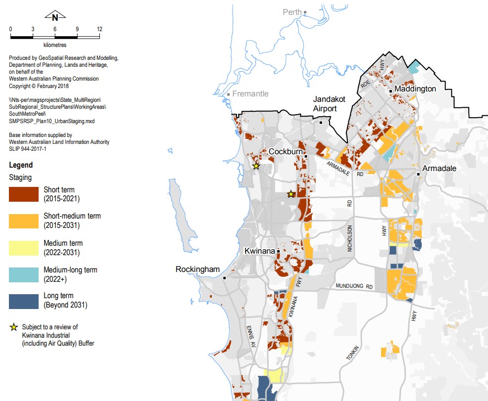
The South Metropolitan Peel sub-region report, produced by the Western Australian Planning Commission, indicates that a significant portion of future development will take place on land already designated for urban use. This encompasses ongoing development between Kwinana-Rockingham and Mandurah-Pinjarra, as well as within emerging urban zones throughout the sub-region, including Byford. A significant focus of future urban development will be situated in Byford area.

Byford Suburb Summary
References
Serpentine-Jarrahdale Shire Planning Scheme (Byford Area)
Serpentine-Jarrahdale: Local Planning Strategy
Serpentine-Jarrahdale: Strategic Community Plan 2017 – 2027 (2019 update)
Byford District Structure Plan
Shire of Serpentine Jarrahdale planning information
Byford – Perth and Peel @ 3.5 million - WA Planning Submission
Google Streetview and Aerial
Structure Plans
Byford Area D – Briggs & Larsen Precinct
Byford Main Precinct - The Glades
Byford Town Centre – Technical Appendices
Doley Road Precinct – Technical Appendices
L1, L3 & L128 South Western Highway, Byford - Map
L1, L3 & L128 South Western Highway, Byford - Report
Lot 6 and Lot 27 Abernethy Road, Byford - Grange Meadows
Lot 806 South Western Highway, Byford
Lot 9500 Thomas Road, Briggs Road, Byford - Byford Meadows Estate
Lots 59-62 Briggs Road, Byford
Marri Park Estate - Lot 3 Larsen Rd and Lot 3 Alexander Road, Byford
Marri Park Estate - Lot 3 Larsen Rd and Lot 3 Alexander Road, Byford - Stage 6