
Carramar Drive Estate - Gol Gol
This information is estimated by the OpenLot research team. Let us know here to provide up-to-date information about this development.
| Total new homes | 10 |
| Area size | 2.80 hectares |
| City council | Wentworth Shire Council |
| Developer | N/A |
| Project marketer | Area Specialist |
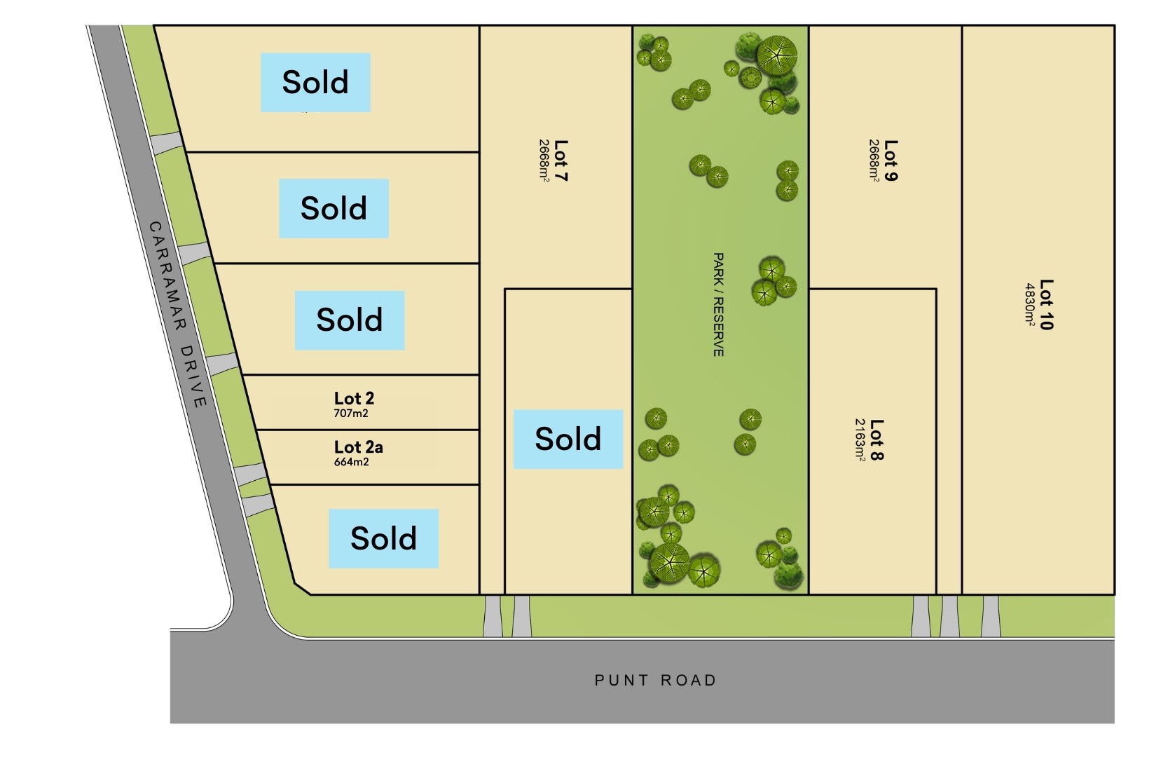
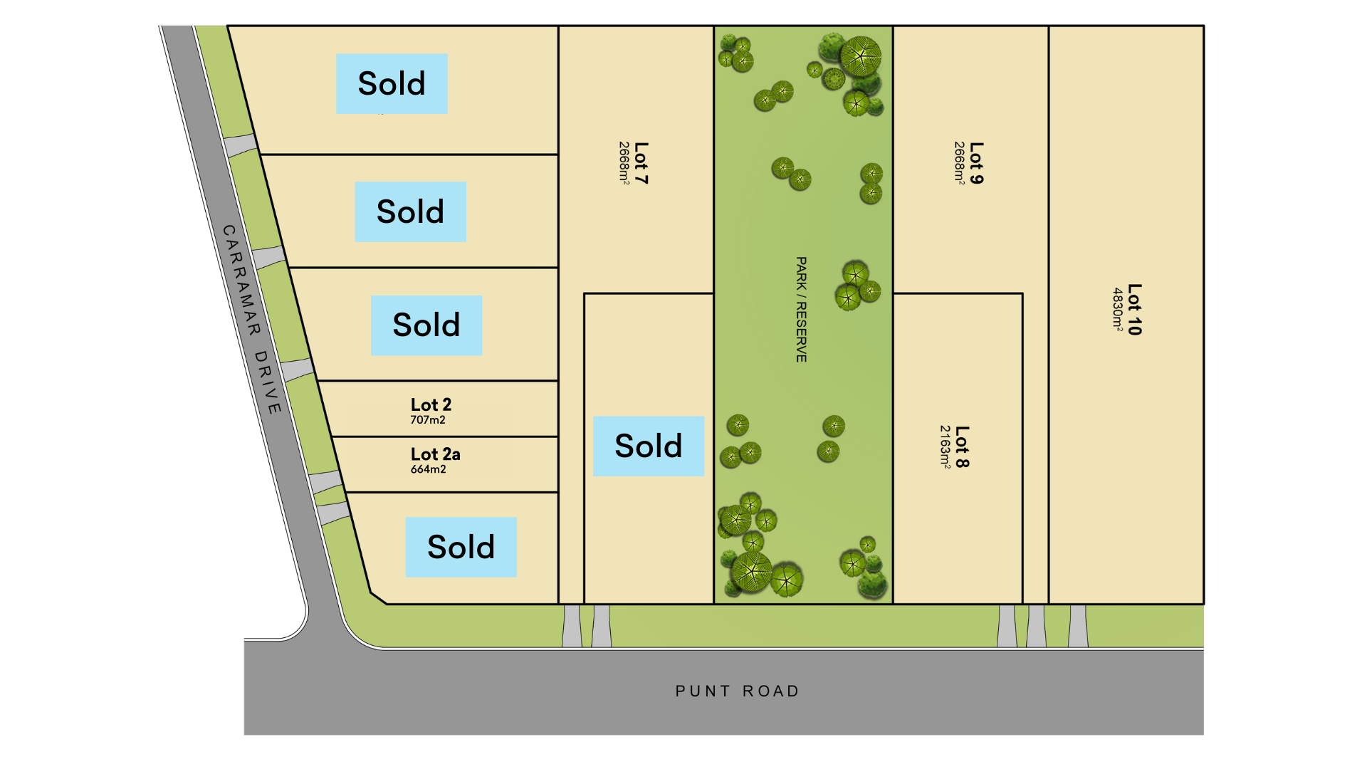
Land for Sale, House and Land Packages:
Popular Estates near Carramar Drive Estate - Gol Gol


Updates for Carramar Drive Estate - Gol Gol
Facebook updates:
Submit the Facebook page for Carramar Drive Estate - Gol Gol.
Related news:
Nestled in the highly sought-after Carramar Estate in Gol Gol, a unique opportunity unfolds for discerning buyers. Presenting a limited collection of premium land parcels, each offering a blank canvas to bring your architectural dreams to life. With sizes ranging from a cozy 644sqm to an expansive 2668sqm, the possibilities are as vast as the horizons of this vibrant community.Key Features:Variety of Sizes: Choose from 644sqm, 707sqm, 2163sqm, and 2668sqm – each block promising ample space for your bespoke residence.Ready to Build: Titled and primed for construction, with water, power, and internet services already in place, ensuring a seamless start to your building journey.Value Assurance: Rest easy knowing your investment is secure, surrounded by homes that reflect the high calibre and elegance of Carramar Estate.Nature at Your Doorstep: The heart of the estate will feature a beautifully designed park/reserve, courtesy of the council, offering a serene escape within your neighborhood.Exclusive Access: Select battle-axe shaped blocks offer the unique advantage of a private, tree-lined driveway, with the option to add a gate for that extra touch of exclusivity and privacy.Lifestyle & Location:Carramar Estate is not just a place to live; it's a lifestyle choice. A short drive from the iconic Gol Gol Pub and the bustling Midway Centre, you're perfectly positioned to enjoy the best of both worlds – the tranquility of New South Wales' growing pocket and the convenience of nearby Mildura's extensive services, amenities, and shopping experiences.Your Opportunity:This is more than just land; it's a foundation for your future. Whether you envision a sprawling family home with lush gardens, a modern architectural masterpiece, or a private retreat, Carramar Estate offers the perfect backdrop. Embrace the opportunity to create something truly special in a community that values privacy, quality, and a connection to nature.Our signs are everywhere... For more Real Estate in Mildura contact your Area Specialist.Did you know we have a rental department who can service your investment properties?If you would like more information please get in contact.Note: Every care has been taken to verify the accuracy of the details in this advertisement, however,we cannot guarantee its correctness. Prospective purchasers are requested to take such action as isnecessary, to satisfy themselves of any pertinent matters.
* Undeniably the best location in Gol Gol is the sought after Carramar Drive Estate * On offer here is your opportunity to secure land in this stunnin

Missing articles? Send us a link here.
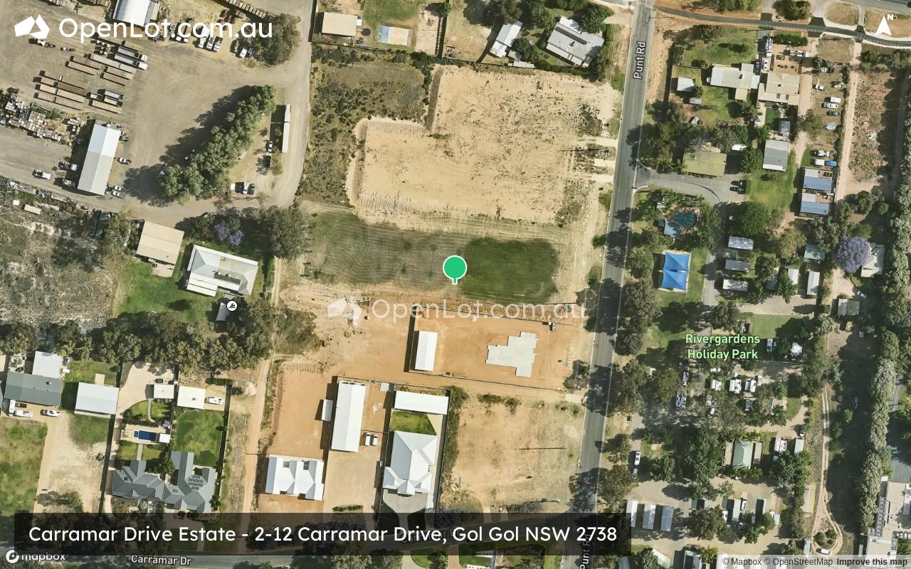
Location & Map for Carramar Drive Estate - Gol Gol
Vacancy Rate in Gol Gol NSW 2738
View full vacancy rate history in Gol Gol NSW 2738 via SQM Research.
Schools near Carramar Drive Estate - Gol Gol
Here are 6 schools near Carramar Drive Estate - Gol Gol:
K-6 Government Primary School
K-6 Government Primary School
Prep-6 Government Primary School
Prep-6 Government Primary School - School Head Campus
7-12 Catholic Secondary School - School Head Campus
Prep-6 Government Primary School
Reviews & Comments on Carramar Drive Estate - Gol Gol
Estate Brochure, Masterplan, Engineering Plan, Plan of Subdivision (POS), Design Guidelines
FAQs about Carramar Drive Estate - Gol Gol
View all estates marketed by Area Specialist
- Gol Gol Public School - 1.3km east
- Buronga Public School - 2.8km north-west
- Nichols Point Primary School - 3.2km south
- Mildura Primary School - 4.7km west
- St Joseph's College Mildura - 5.2km west
- Mildura West Primary School - 5.2km west
Popular Estates near Carramar Drive Estate - Gol Gol
Latest New Home Articles for You

09/Mar/2026 | OpenLot.com.au
Victoria: Top 30 Most Searched Housing Developments (February 2026)
If you’ve been exploring housing opportunities in Victoria, February 2026...

20/Feb/2026 | OpenLot.com.au
Display Homes at Drouin Fields Estate: A Thriving Community in Drouin
Welcome to Drouin Fields, a place where beauty, space, and modern luxury ...

19/Feb/2026 | OpenLot.com.au
Display Homes at Manor Lakes Esate: A Thriving Waterside Community in Manor Lakes
A place where you can settle in, rather than just settle down. Named for ...

13/Feb/2026 | OpenLot.com.au
🏠 Victoria: Top 30 Most Searched Townhouse Developments – January 2026

11/Feb/2026 | OpenLot.com.au
🏡 Top 30 Most Searched Estates by State - January 2026

10/Feb/2026 | OpenLot.com.au
Victoria: Top 30 Most Searched Housing Developments (January 2026)
If you’ve been considering making a move in Victoria, January 2026 offere...

10/Feb/2026 | OpenLot.com.au
Queensland: Top 30 Most Searched Housing Developments (January 2026)
If you’ve been considering making a move in Queensland, January 2026 offe...

09/Feb/2026 | OpenLot.com.au
Western Australia: Top 30 Most Searched Housing Developments (January 2026)
If you’ve been considering making a move in Western Australia, January 20...

06/Feb/2026 | OpenLot.com.au
South Australia: Top 30 Most Searched Housing Developments (January 2026)
If you’ve been considering making a move in South Australia, January 2026...