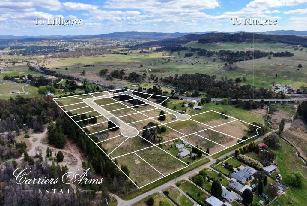
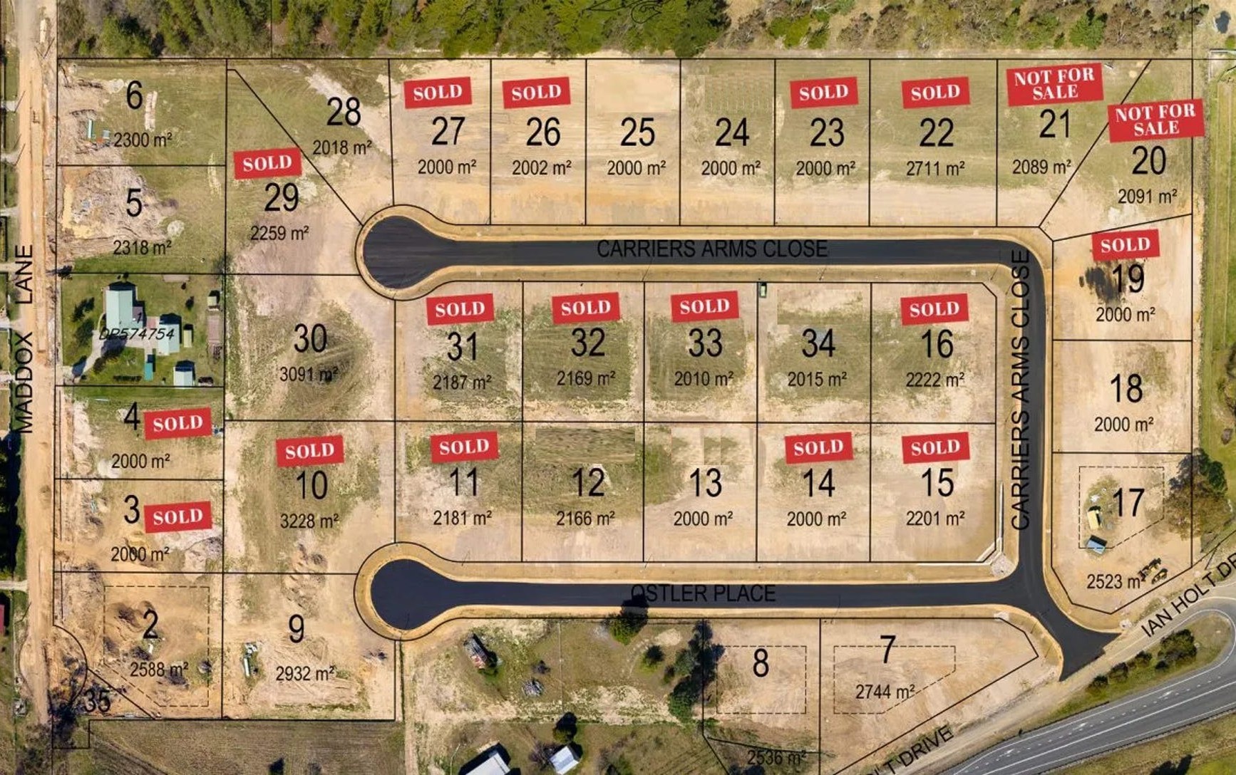
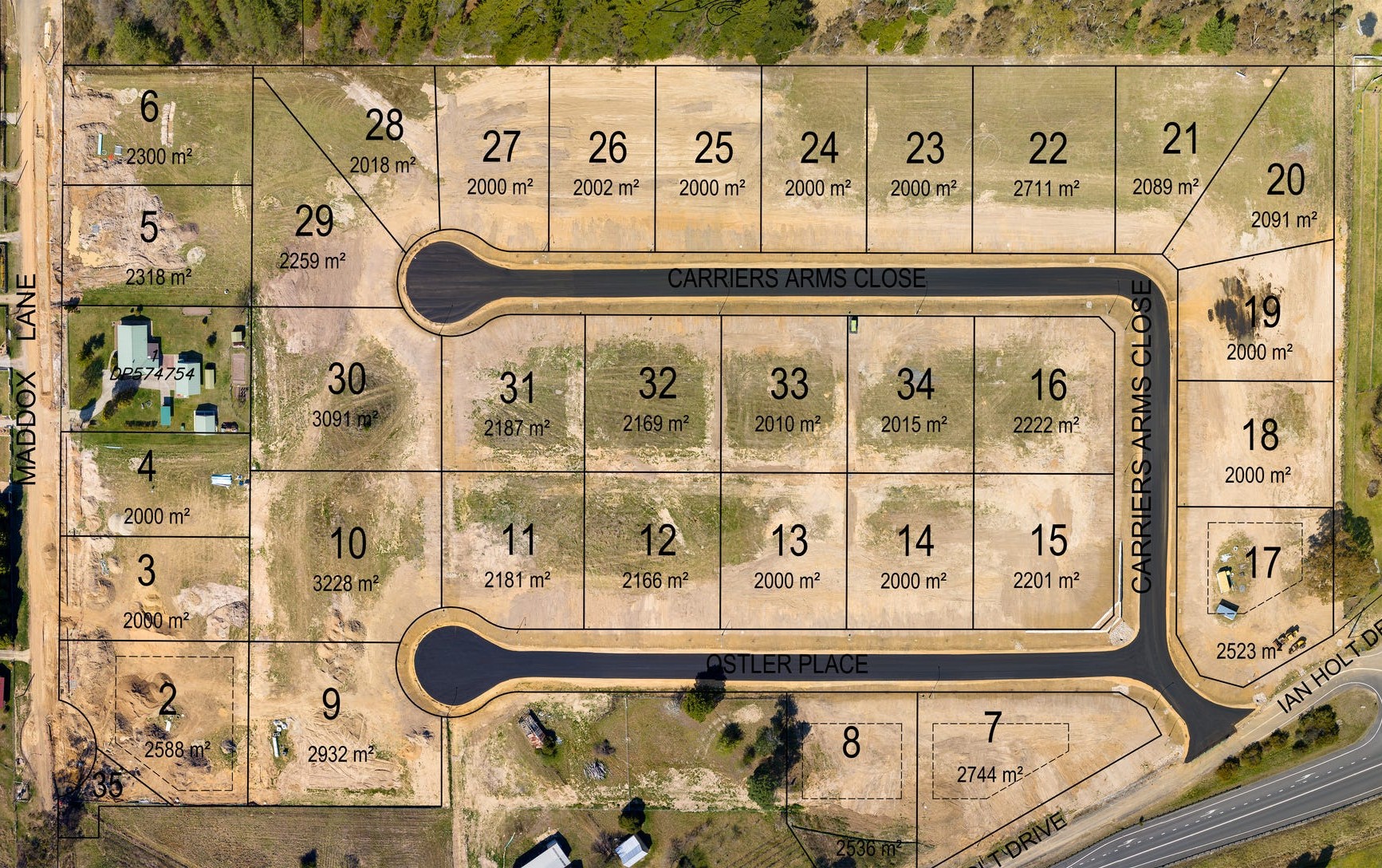
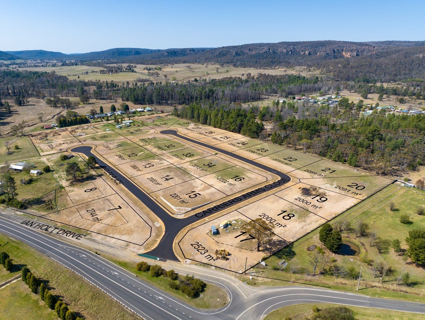
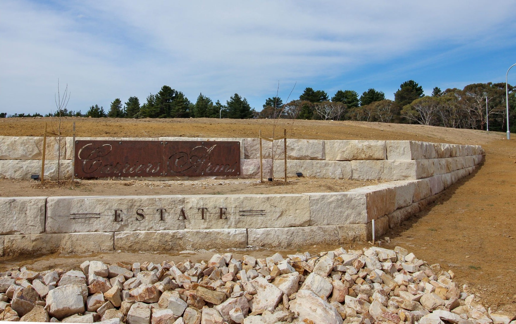

Carriers Arms Estate - Lidsdale
[LIMITED OFFER] Brand new premium large lot residential
This information is estimated by the OpenLot research team. Let us know here to provide up-to-date information about this development.
| Total new homes | 33 |
| Area size | 8.80 hectares |
| City council | Lithgow City Council |
| Developer | N/A |
| Project marketer | Elders Emms Mooney |
Land for Sale, House and Land Packages:
Popular Estates near Carriers Arms Estate - Lidsdale


Updates for Carriers Arms Estate - Lidsdale
Facebook updates:
Submit the Facebook page for Carriers Arms Estate - Lidsdale.
Related news:
For Sale at 103 Ian Holt Drive, Lidsdale, NSW, 2790. View property details, features, photos, floor plans and more at Elders Real Estate!

"Carriers Arms Estate" Stage 1 Complete – 22 Blocks Sold - Register Your Interes - 103 Ian Holt Drive, Lidsdale, NSW 2790 - 16/12/2021 for sale #1C3VF9X - LJ Hooker Lithgow

Missing articles? Send us a link here.
Location & Map for Carriers Arms Estate - Lidsdale
Vacancy Rate in Lidsdale NSW 2790
View full vacancy rate history in Lidsdale NSW 2790 via SQM Research.
Schools near Carriers Arms Estate - Lidsdale
Here are 6 schools near Carriers Arms Estate - Lidsdale:
K-6 Government Primary School
K-6 Catholic Primary School
K-12 Government Combined School
K-6 Government Primary School
K-6 Government Primary School
K-6 Catholic Primary School
Reviews & Comments on Carriers Arms Estate - Lidsdale
Estate Brochure, Masterplan, Engineering Plan, Plan of Subdivision (POS), Design Guidelines
FAQs about Carriers Arms Estate - Lidsdale
View all estates marketed by Elders Emms Mooney
- Wallerawang Public School - 4.2km south
- St Joseph's Catholic Primary School Portland - 9.2km west
- Portland Central School - 9.9km west
- Cullen Bullen Public School - 10.2km north-west
- Cooerwull Public School - 12.7km south-east
- St Patrick's Catholic Primary School Lithgow - 13.2km south-east
Popular Estates near Carriers Arms Estate - Lidsdale
Latest New Home Articles for You

09/Mar/2026 | OpenLot.com.au
Victoria: Top 30 Most Searched Housing Developments (February 2026)
If you’ve been exploring housing opportunities in Victoria, February 2026...

20/Feb/2026 | OpenLot.com.au
Display Homes at Drouin Fields Estate: A Thriving Community in Drouin
Welcome to Drouin Fields, a place where beauty, space, and modern luxury ...

19/Feb/2026 | OpenLot.com.au
Display Homes at Manor Lakes Esate: A Thriving Waterside Community in Manor Lakes
A place where you can settle in, rather than just settle down. Named for ...

13/Feb/2026 | OpenLot.com.au
🏠 Victoria: Top 30 Most Searched Townhouse Developments – January 2026

11/Feb/2026 | OpenLot.com.au
🏡 Top 30 Most Searched Estates by State - January 2026

10/Feb/2026 | OpenLot.com.au
Victoria: Top 30 Most Searched Housing Developments (January 2026)
If you’ve been considering making a move in Victoria, January 2026 offere...

10/Feb/2026 | OpenLot.com.au
Queensland: Top 30 Most Searched Housing Developments (January 2026)
If you’ve been considering making a move in Queensland, January 2026 offe...

09/Feb/2026 | OpenLot.com.au
Western Australia: Top 30 Most Searched Housing Developments (January 2026)
If you’ve been considering making a move in Western Australia, January 20...

06/Feb/2026 | OpenLot.com.au
South Australia: Top 30 Most Searched Housing Developments (January 2026)
If you’ve been considering making a move in South Australia, January 2026...