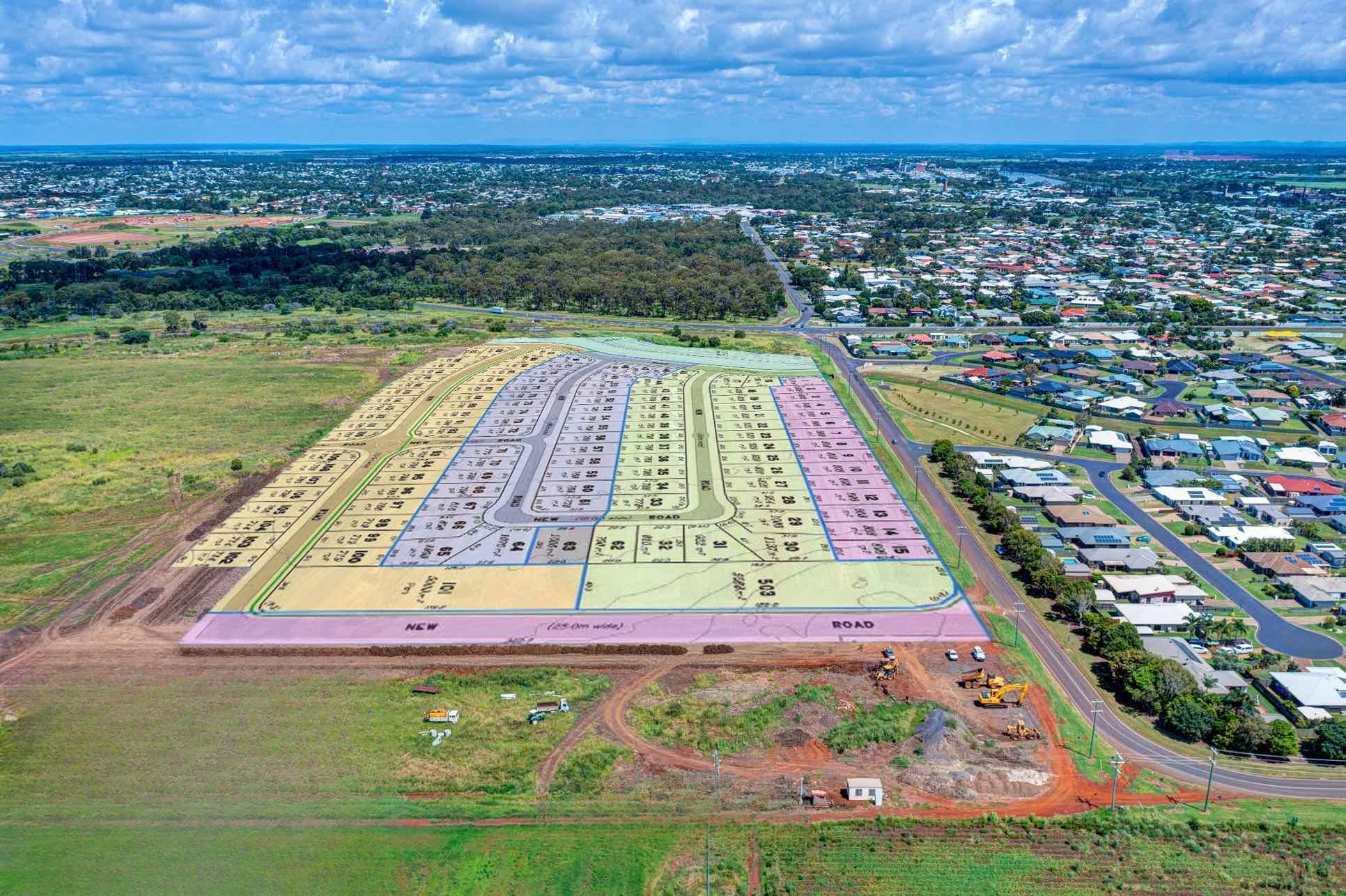
Kalkie Heights Estate - Kalkie COMING SOON
[NEW RELEASE] Stage 1&2 SOLD! Please register for the next release!
- 10 min to Bargara beach
- 10 min to Bundaberg CBD
- Above the flood plane
- Minutes to private and public schools
- Next stage released soon!
This information is estimated by the OpenLot research team. Let us know here to provide up-to-date information about this development.
| Total new homes | 194 |
| Area size | 30.88 hectares |
| Growth Region | Hervey Bay (Wide Bay–Burnett Region) |
| City council | Bundaberg Regional Council |
| Developer | N/A |
Land for Sale:
Popular Estates near Kalkie Heights Estate - Kalkie


Updates for Kalkie Heights Estate - Kalkie
Facebook updates:
Related news:
Almost 200 new residential lots have been approved on Telegraph Road in Kalkie after a development application was lodged with Council.

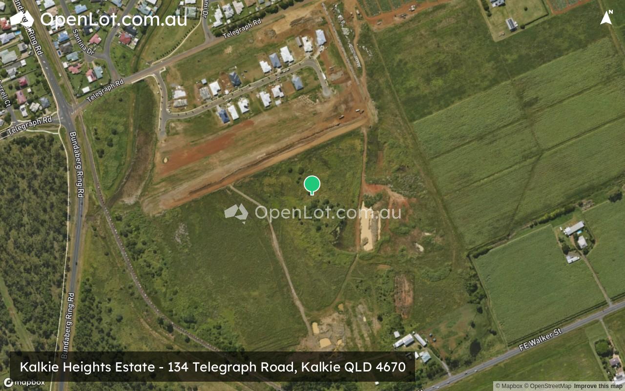
134 Telegraph Road, KALKIE , Vacant Land for Sale . Tanja Brown - First National Real Estate McColms

The official Bundaberg Regional Council Application Tracker
Missing articles? Send us a link here.
Location & Map for Kalkie Heights Estate - Kalkie
Schools near Kalkie Heights Estate - Kalkie
Here are 6 schools near Kalkie Heights Estate - Kalkie:
Prep-12 Independent Combined School
Prep-6 Government Primary School
Prep-12 Independent Combined School
Prep-6 Government Primary School
7-12 Government Secondary School
Prep-6 Government Primary School
Reviews & Comments on Kalkie Heights Estate - Kalkie
Estate Brochure, Masterplan, Engineering Plan, Plan of Subdivision (POS), Design Guidelines
FAQs about Kalkie Heights Estate - Kalkie
- St Luke's Anglican School - 875m north-west
- Kalkie State School - 1.8km north
- Bundaberg Christian College - 1.8km south-east
- Bundaberg East State School - 1.9km west
- Kepnock State High School - 2.2km south-west
- Woongarra State School - 2.5km south-east
Popular Estates near Kalkie Heights Estate - Kalkie
Latest New Home Articles for You

16/Mar/2026 | OpenLot.com.au
New South Wales: Top 30 Most Searched Housing Developments (February 2026)
If you’ve been considering a move in New South Wales, February 2026 provi...

09/Mar/2026 | OpenLot.com.au
Victoria: Top 30 Most Searched Housing Developments (February 2026)
If you’ve been exploring housing opportunities in Victoria, February 2026...

20/Feb/2026 | OpenLot.com.au
Display Homes at Drouin Fields Estate: A Thriving Community in Drouin
Welcome to Drouin Fields, a place where beauty, space, and modern luxury ...

19/Feb/2026 | OpenLot.com.au
Display Homes at Manor Lakes Esate: A Thriving Waterside Community in Manor Lakes
A place where you can settle in, rather than just settle down. Named for ...

13/Feb/2026 | OpenLot.com.au
🏠 Victoria: Top 30 Most Searched Townhouse Developments – January 2026

11/Feb/2026 | OpenLot.com.au
🏡 Top 30 Most Searched Estates by State - January 2026

10/Feb/2026 | OpenLot.com.au
Victoria: Top 30 Most Searched Housing Developments (January 2026)
If you’ve been considering making a move in Victoria, January 2026 offere...

10/Feb/2026 | OpenLot.com.au
Queensland: Top 30 Most Searched Housing Developments (January 2026)
If you’ve been considering making a move in Queensland, January 2026 offe...

09/Feb/2026 | OpenLot.com.au
Western Australia: Top 30 Most Searched Housing Developments (January 2026)
If you’ve been considering making a move in Western Australia, January 20...