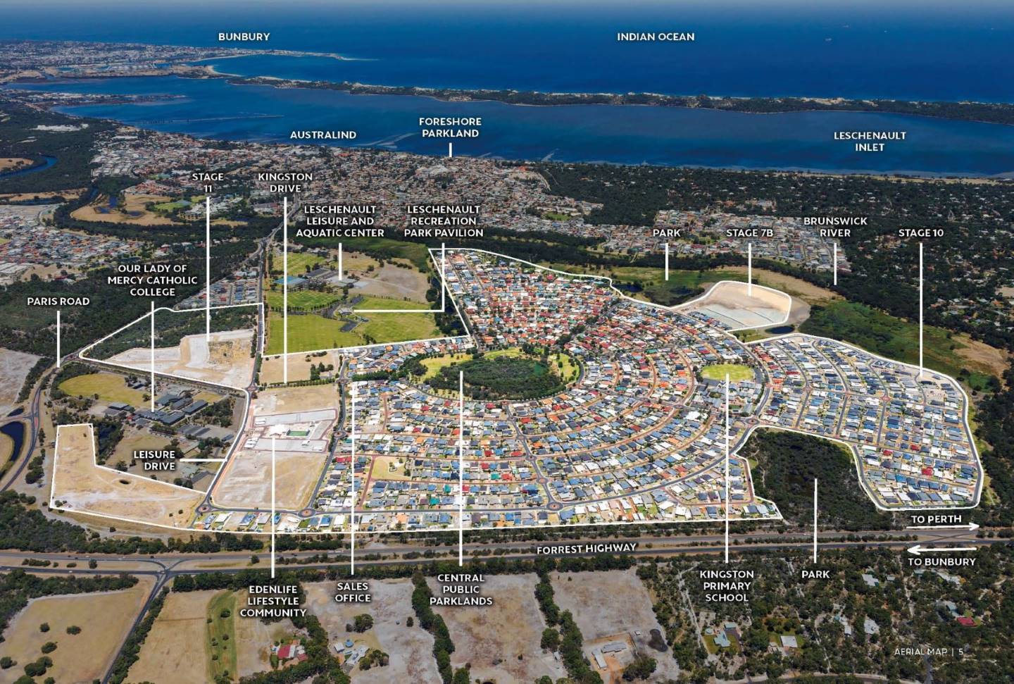

Kingston Estate - Australind
This information is estimated by the OpenLot research team. Let us know here to provide up-to-date information about this development.
| Total new homes | 1,400 |
| Area size | 185.00 hectares |
| Growth Region | Bunbury (The South West Region) |
| City council | Shire of Harvey |
| Developer | The Lester Group |
Land for Sale, House and Land Packages:
Popular Estates near Kingston Estate - Australind


Updates for Kingston Estate - Australind
Facebook updates:
Related news:
Kingston at Australind is a major 1400 lot residential subdivision development currently half way through development. Kingston provides a comprehensive community infrastructure and range of housing styles, as well as a primary school, neighbourhood shopping centre and retirement village facilities. The massive 185 hectare site is bounded on its northern and western sides by the […]

Missing articles? Send us a link here.
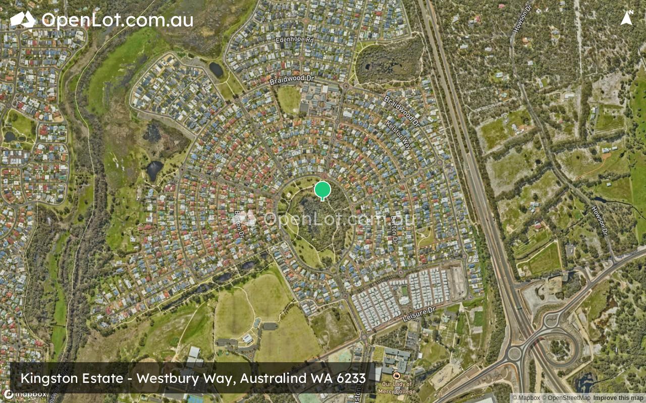
Location & Map for Kingston Estate - Australind
Vacancy Rate in Australind WA 6233
View full vacancy rate history in Australind WA 6233 via SQM Research.
Schools near Kingston Estate - Australind
Here are 6 schools near Kingston Estate - Australind:
K-6 Government Primary School
7-12 Catholic Secondary School
K-6 Government Primary School
7-12 Government Secondary School
K-6 Government Primary School
K-6 Government Primary School
Reviews & Comments on Kingston Estate - Australind
Estate Brochure, Masterplan, Engineering Plan, Plan of Subdivision (POS), Design Guidelines
FAQs about Kingston Estate - Australind
View all estates from The Lester Group
- Kingston Primary School - 490m north
- Our Lady of Mercy College - 738m south-east
- Parkfield Primary School - 1.7km west
- Australind Senior High School - 2.1km south-west
- Treendale Primary School - 2.2km south
- Australind Primary School - 2.4km south-west
Popular Estates near Kingston Estate - Australind
Latest New Home Articles for You

09/Mar/2026 | OpenLot.com.au
Victoria: Top 30 Most Searched Housing Developments (February 2026)
If you’ve been exploring housing opportunities in Victoria, February 2026...

20/Feb/2026 | OpenLot.com.au
Display Homes at Drouin Fields Estate: A Thriving Community in Drouin
Welcome to Drouin Fields, a place where beauty, space, and modern luxury ...

19/Feb/2026 | OpenLot.com.au
Display Homes at Manor Lakes Esate: A Thriving Waterside Community in Manor Lakes
A place where you can settle in, rather than just settle down. Named for ...

13/Feb/2026 | OpenLot.com.au
🏠 Victoria: Top 30 Most Searched Townhouse Developments – January 2026

11/Feb/2026 | OpenLot.com.au
🏡 Top 30 Most Searched Estates by State - January 2026

10/Feb/2026 | OpenLot.com.au
Victoria: Top 30 Most Searched Housing Developments (January 2026)
If you’ve been considering making a move in Victoria, January 2026 offere...

10/Feb/2026 | OpenLot.com.au
Queensland: Top 30 Most Searched Housing Developments (January 2026)
If you’ve been considering making a move in Queensland, January 2026 offe...

09/Feb/2026 | OpenLot.com.au
Western Australia: Top 30 Most Searched Housing Developments (January 2026)
If you’ve been considering making a move in Western Australia, January 20...

06/Feb/2026 | OpenLot.com.au
South Australia: Top 30 Most Searched Housing Developments (January 2026)
If you’ve been considering making a move in South Australia, January 2026...