
Hilbert is with the City of Armadale located 31 kilometres south east of Perth and named after the Hilbert family who were dairy farmers within the area. Hilbert is approximately 9.1sq km, which is bounded by Tonkin Highway to the east, property boundaries and Rowley Road to the south. Forrest Road is the boundary to the north, Powell Crescent, Wungong Road and Ninth Road to the west.
The Armadale City Council undertook public consultation and within a committee meeting on 12 June 2007 agreed to rename part of Brookdale as Hilbert. Council sought approval from the Geographic Names Committee (GNC), which was agreed and the suburb of Hilbert came into effect on 1 April 2008.

Hilbert - Council Online Mapping
Southern River, Forrestdale, Brookdale, Wungong District Structure Plan
The Southern River, Forrestdale, Brookdale, Wungong area poses planning challenges due to various factors including a high water table, contaminated sites, offsite impacts from poultry farms and kennels, major infrastructure installations (power lines, gas and water mains), conservation and environmental sites, and land fragmentation. To address these concerns, the Western Australian Planning Commission, in collaboration with the Cities of Gosnells and Armadale and key stakeholders, has prepared the Southern River/Forrestdale/Brookdale/Wungong District Structure Plan. This structure plan was published on 11 August 2021 by the WA Department of Planning, Lands and Heritage
Hilbert, WA falls within the jurisdiction Wungong District, administered by the City of Armadale. The area is governed by the City's Local Planning Scheme No. 26 (Amendment 110), which was approved by the Minister of Planning and published in the Government Gazette on 3 May 2022. A report regarding this scheme was presented to the council during their Ordinary Council Meeting on 26 July 2022.
The District Structure Plan will provide a guide for the City of Armadale town planning schemes and Local Planning Strategies.
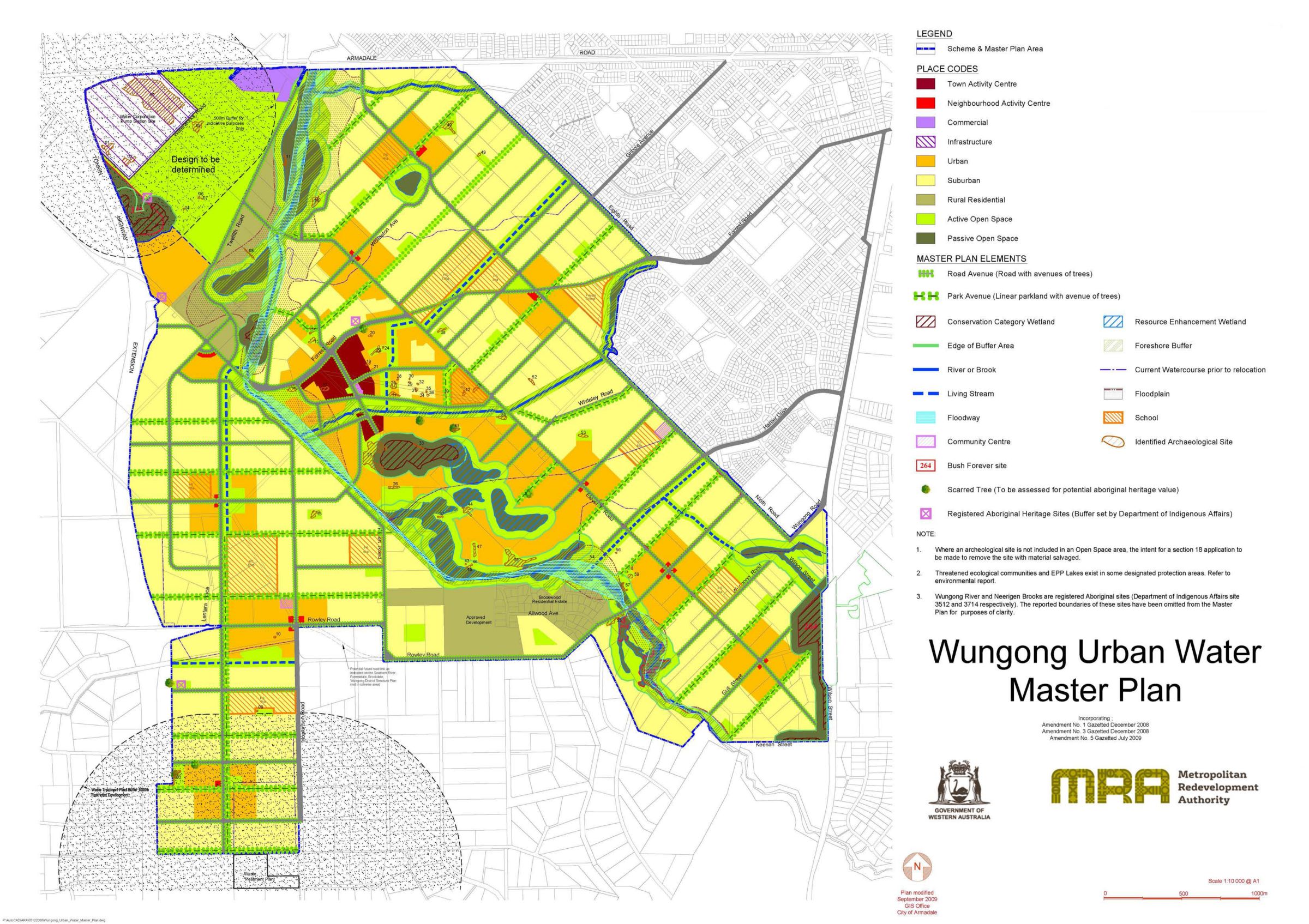
Armadale Redevelopment Scheme 2
The Armadale Redevelopment Area is made up of several individual project areas. The project areas are dispersed across the Armadale Redevelopment Area but together make up the Scheme Area. Hilbert is located within the Wungong Urban Water Project Area (Wungong), which has a vision for the type of urban community and provides development precincts.
Vision – “The vision for the Wungong Urban Water (Wungong) Project Area is to establish a vibrant and sustainable urban community within a landscape that respects and promotes the ecological and cultural features of the site. The project area will implement innovative environmental and urban water management principles while addressing significant housing demand identified under broader strategic planning for the Perth Metropolitan Area”.

Hilbert Precincts
Hilbert Precincts
- Armadale Road
- Brookwood A
- Brookwood B
- Eighth Road
- Eleventh Road
- Forrest Road
- Ninth Road
- Tonkin North
- Tonkin South
- Town Centre
- Recreation
- River
- Rowley Road
- Wungong North
Wungong Urban Project Area
The vision for the Wungong Urban Water (Wungong) Project Area is to create a thriving and sustainable urban community that respects and enhances the natural and cultural features of the site. The project aims to implement innovative environmental and urban water management principles while addressing the housing demand in the Perth Metropolitan Area. The development will prioritise water-sensitive urban design measures, integrate with natural drainage systems, and promote efficient use of resources and infrastructure. The project area will also protect environmentally and culturally significant areas through the provision of buffers and compatible land uses.
A key aspect of the project will be the establishment of multi-functional corridors called 'Park Avenues' and 'Living Streams.' These corridors will serve as water management systems, transportation routes, and public open spaces, fostering community interaction and promoting the well-being of residents. Additionally, the project will include the creation of a district-level activity centre and a network of neighbourhood activity centres. These centres will offer diverse retail, commercial, and employment opportunities, encouraging self-contained, well-connected, and walkable neighbourhoods that reduce reliance on private vehicles.
Development within the Wungong Project Area will adhere to the District Water Management Strategy and strive for sustainable urban development and water management practices. The focus is on conserving wetlands, improving water quality, and minimising environmental impacts. Efforts will be made to reduce the mobilisation of existing contaminants and mitigate contamination outputs from development activities. The aim is to achieve improved post-development surface water quality compared to pre-development conditions.
Wungong Urban Master Plan
The Wungong Urban redevelopment aims to create a sustainable and innovative community, accommodating approximately 40,000 residents. It includes the establishment of a new town centre with schools, open spaces, parklands, and sports facilities. The design prioritises environmentally sustainable urban principles, safeguarding natural landscapes and waterways.
With 12 kilometres of living streams and public spaces for recreation, the project offers a serene environment. Wungong Urban provides a range of housing options, including over 16,000 lots conveniently accessible from Tonkin Highway and Armadale Road. As part of the State Affordable Housing Strategy, the Sienna Woods housing development, a collaboration between the Department of Housing and Stockland, comprises 2,600 lots and caters to around 6,000 people, including public housing provisions.
- Sustainable and innovative community, with new homes for approximately 40,000 people.
- Establishment of a new town centre with primary and secondary schools
- Open spaces, parklands, and sports facilities.
- Prioritise environmentally sustainable principles to protect natural landscapes and waterways.
- Living streams, with public spaces for residents and visitors to enjoy
- Range of housing options, including over 16,000 lots, with easy access to Tonkin Highway
- As part of the State Affordable Housing Strategy, the Department of Housing and Stockland have collaborated on the Sienna Woods housing development, which includes 2,600 lots, a population of around 6,000 people, and a portion allocated for public housing.
Hilbert (Wungong Urban) – Zoning Map
Retail/Commercial Centres
The City of Armadale has recently approved an Activity Centre Structure Plan for the Armadale Strategic Metropolitan Centre, which is considered its most significant centre. The Structure Plan complements the overall strategy for the area and incorporates its findings and recommendations. With the rapid population growth in the City, there are opportunities for establishing new centres and revitalising existing ones. The Armadale City Centre, in particular, holds great potential as it serves as the primary centre for a wide catchment area that extends beyond the City's boundaries.
The emerging residential population in Haynes and Hilbert suburbs will require the establishment of Local Centres to complement the existing District and Neighbourhood Centres. The development of the Wungong Urban Water Master Plan has influenced the refinement of these Local Centres to align with the area's growth. The Wungong Urban Water Master Plan initially included eleven centres that range from District Centres to Local Centres.
Detailed structure plans have been adopted to provide for:
- Hilbert District Centre
- Hilbert South Neighbourhood Centre
- Hilbert East Neighbourhood Centre
- Six Local Centres
Two future local activity centres are planned:
- Haynes South East
- Hilbert South East
- Hilbert - Council Retail Activation Centres
- Hilbert - Council Retail Activation Centres
Featured Developments in Hilbert
Stockland Sienna Wood - Hilbert
 1 AVAILABLELand for Sale Connected living, surrounded by nature.
Stockland Sienna Wood - Hilbert


Hilbert Suburb Summary
References
Armadale, WA - Hilbert Town Activity Centre
Armadale, WA – Albert Retail Centres Strategy Map
Armadale, WA – Plan for the Future 2011 - 2025
Armadale, WA – Albert Retail Centres Strategy Map
Development WA - Armadale Redevelopment Scheme 2
Development WA – Wungong Urban
Southern River/Forrestdale/ Brookdale/Wungong District Structure Plan (2001


