


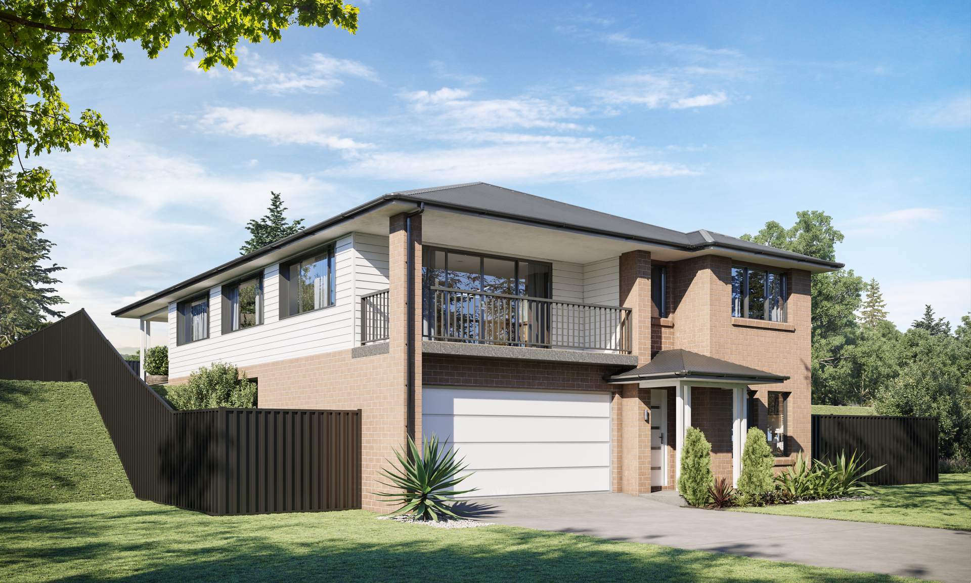

Parkside Estate - Kembla Grange
[LIMITED OFFER] PARKSIDE Kembla Grange- (Lot #5) Premium Flat Block- Registration Expected Mid-2023
- - Level (450 m2) block
-Positioned at the top of the hill
-North Facing rear yard
-Directly opposite parkland
-Amazing outlook
-Expected to register early 2023. - Cradled in a coastal plain between mountain and sea is an address that feels picturesque and calm, yet connected and accessible. Adjacent to 8-hectare nature park, forever views of stunning surrounds and cosmopolitan living that comes naturally. Kembla Grange is among the state's fastest growing suburbs with a population growth rate of 9.1 per cent between 2020 and 2021.
- Close to everything you need.
Easy access to motorway and everything you need to give you more time to do the things that you love.
Views you will never tire of, positioned on top of the hill.
Build your home with a backdrop that becomes like a permanent work of art, constantly changing with the seasons and the light of day. - Nature on your doorstep.
Parkside’s 8-hectare park not only expands your backyard, but gives you a chance to interact, socialise and explore.
This information is estimated by the OpenLot research team. Let us know here to provide up-to-date information about this development.
| Total new homes | N/A |
| Area size | N/A |
| Growth Region | Wollongong (Illawarra-Shoalhaven Region) |
| City council | Wollongong City Council |
| Developer | N/A |
| Project marketer | MMJ Project Marketing |
| Creative agency | Endure Web Studios |
| Distance to | Wollongong CBD - 11 km south-west Sydney CBD - 77 km south-west |
Land for Sale:
Popular Estates near Parkside Estate - Kembla Grange


 4
4
 2
2
 1
1


Updates for Parkside Estate - Kembla Grange
Facebook updates:
Related news:
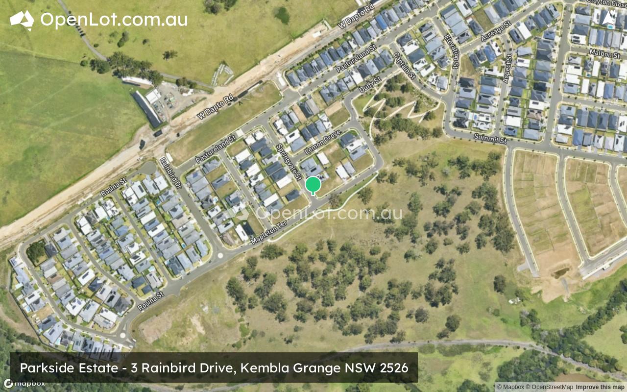
Kembla Grange is approximately 14.6 square kilometre within the Wollongong City Council, forming part of the Sydney Basin area in New South Wales, located 76.2 kilometres south west of Sydney.

Missing articles? Send us a link here.
Location & Map for Parkside Estate - Kembla Grange
Visit Display Homes near Parkside Estate - Kembla Grange


Vacancy Rate in Kembla Grange NSW 2526
View full vacancy rate history in Kembla Grange NSW 2526 via SQM Research.
Schools near Parkside Estate - Kembla Grange
Here are 6 schools near Parkside Estate - Kembla Grange:
K-6 Government Primary School
K-6 Catholic Primary School
7-12 Government Secondary School
7-12 Government Secondary School
K-6 Government Primary School
K-6 Government Primary School
Suburb Planning Review in Kembla Grange NSW 2526
Kembla Grange is approximately 14.6 square kilometre within the Wollongong City Council, forming part of the Sydney Basin area in New South Wales, located 76.2 kilometres south west of Sydney.
The southern portion of the suburb is primarily rural land holdings, with Mount Kemble found in the north within the Illawarra Escarpment State Conservation Area and rural residential properties. The only pocket of low density housing is found in the east with an increased density. The centre of the suburb is a mixed industrial area containing an electricity substation, waste and resource recovery centre, concrete plant, auto car storage and service centre. The suburb does not have a business district, though has a range of outdoor recreation / activities in the south east, including gold course, motor museum, racetrack and go karting.
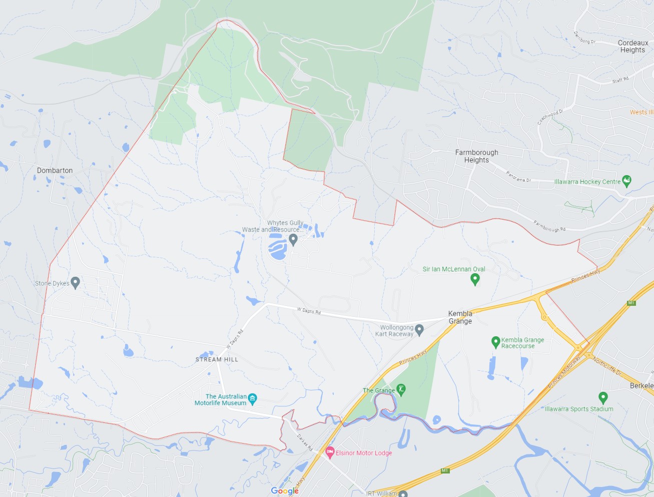
The suburb boundary is located along property boundaries to the west. The suburb boundaries to the north are along existing property boundaries and the existing rail line corridor. The Princess Motorway, Princess Highway, Mullet Creek, and property boundaries provide the eastern boundary and the existing rail corridor provides the boundary to the south.
A series of small creeks, gullies and overland flow paths extending from Mullet Creek, linking dams throughout the suburb. W Dapto Road provides access to the surrounding suburbs and local government areas, with a local network of roads providing access to the rural area.


Illawarra Shoalhaven Regional Plan 2036
The Illawarra Shoalhaven Regional Plan (ISRP) was released in 2015 and provides the strategic framework for future growth in the Region over the next 20 years. Since then, the NSW Government has delivered further documents, including the State Infrastructure Strategy 2018-2038, Future Transport 2056, A 20-year Economic Vision for Regional NSW and NSW South Coast Marine Tourism Strategy 2019.
The Regional Plan was revised in 2021 and identifies 15 regionally significant precincts that will drive jobs creation, housing diversity, and vibrant communities. These places contain more than 2,300 hectares for employment, hubs for recreation, culture, housing, and innovation, as well as almost 45,000 jobs, and growth areas.
The regional cities of Shellharbour and Nowra align with the vision for the Illawarra Shoalhaven to serve as a central hub for business, government, and culture. They are envisioned as gathering places for civic events, community engagement, and social gatherings, while also serving as attractive destinations for visitors. Both regional cities are strategically situated adjacent to the regionally significant growth areas of West Lake Illawarra and Nowra Bomaderry.
Collectively, these areas comprise the largest urban expansion areas in regional New South Wales, with a combined capacity for 37,600 housing lots. The residents settling in these regions will rely on the regional cities for employment opportunities, access to healthcare and educational services, and recreational activities.
The Regional Plan outlined that a major regional land release areas of in the West Lake Illawarra area includes West Dapto, with the most northern area containing the suburb of Kembla Grange.
West Dapto Structure Plan 2018
The NSW State Government prepared the Illawarra Shoalhaven Regional Plan in 2015 (Regional Plan) which estimates that by 2050 the Illawarra-Shoalhaven region will have a population of about half a million people.
In preparation the Wollongong City Council leased the West Dapto Structure Plan 2018, that revised the initial plan released in 2008. The structure plan was Wollongong City Council estimates the West Dapto Urban Release Area will provide about 19,500 dwellings and an additional population of about 56,500 people once fully developed over 50-plus years. A release plan was also prepared to stage out the proposed land availability to ensure services, infrastructure and community services were included in all new urban redevelopment.

The West Dapto Structure Plan identifies:
- Town and village centres
- Conservation land
- Heritage items and potential curtilages
- Transition land (environmental constraints)
- Development land
- Employment land
- Large open space facilities (neighbourhood parks 2-5 ha, and district parks 5-8 ha)
- Structural road network
- Creek lines and flood extents (1% AEP)

Stages
- Stages 1 and 2 were rezoned for urban development in 2010 and include Kembla Grange to Wongawilli and the area west of Horsley.
- Stage 3 of the urban release area is Cleveland and
- State 4 of the urban release area is Avondale
- Stage 5 (Yallah/Marshall Mount) and the Dapto Town Centre precincts will develop separately.
Kembla Grange (Stage 1 and 2)
Stages 1 and 2 have several unique features, including:
- Potential development of around 6,700 dwellings.
- Employment land (industrial zones) located close to Unanderra light industrial area and well connected to Dapto Regional Centre along the Princes Highway, Port Kembla, and the M1 Motorway.
- South of the employment lands will be home to Darkes Town Centre, approx. 7,500m2 of commercial/ retail floor space providing for a range of shops and services as well as community
facilities and active open space for community recreation.
- Protection and rehabilitation of riparian corridors and conservation areas (vegetation and
- Improved water quality, recreational opportunities, and connectivity of remnant vegetation
- Structural road network that will connect from outside the release area
- Active transport facilities (cycleways and shared paths) connecting residential areas
- Two village centres (Wongawilli and Jersey Farm) providing local convenience shops
- Two primary schools at Darkes Town Centre and Wongawilli and Jersey Farm Roads
- Bong Bong Town Centre will provide retail needs, local services, and community facilities
- Employment opportunities supporting opportunity for denser housing products.
- located convenient to public and active transport links.
To date development has occurred in the Kembla Grange (northern area) that will gradually extend south while also widening east to west.
Wollongong DCP 2009
Wollongong Development Control Plan 2009 (DCP) provides the guidance for the future development of the West Dapto Urban Release Area and includes the following Vision:
“West Dapto will grow and develop as a series of integrated and connected communities. Set against the spectacular Illawarra Escarpment and a landscape of riparian valleys, these communities will integrate the natural and cultural heritage of the area with the new urban form. The communities will be healthy, sustainable, and resilient with active and passive open space accessible by walkways, cycleways, and public transport.
To support these new communities, local centres will provide shopping services, community services and jobs while employment lands will facilitate further opportunities for the region. West Dapto will be supported by a long-term strategy to oversee the timely implementation of infrastructure to deliver sustainable and high-quality suburbs with diverse housing choices”.
Five out of the seven Employment Principles outlined in the West Dapto Vision 2018 are designed to provide guidance for the development and establishment of sustainable employment opportunities in the West Dapto Urban Release Area.
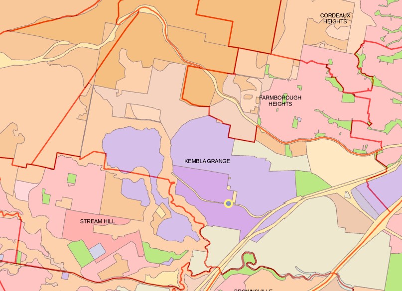
The objective of creating job opportunities within proximity to West Dapto and its vicinity not only allows residents to work near their homes but also has the potential to alleviate the overall traffic impact associated with the development. The Structure Plan highlights the primary employment area located in the northern part of the release area at Kembla Grange, marked in purple. This land is predominantly designated for light and heavy industrial purposes. Furthermore, there are limited areas designated for light industrial use organized in an enterprise corridor to the north and south of the Dapto Regional Centre, as well as some parcels situated to the west of the M1 and along Yallah Road in Yallah, all aimed at providing additional employment opportunities within the local community.
Wollongong LEP 2009
In the Wollongong LEP 2009, Stage 1–2, some of Stages 3 and 4, and all of Stage 5 of the release area are zoned for residential development. There is also 175 hectares of employment land zoned at Kembla Grange.
Precinct Zoning of Kembla Grange
The current zoning provides heavy and light industrial towards the centre of the suburb, providing employment industries for the growth area and surrounding suburbs with large residential areas.
Kembla Grange Suburb Summary
References
- Illawarra Shoalhaven Regional Plan – NSW State Government
- West Dapto – Wollongong City Council
- West-Dapto-Vision-2018 | Wollongong City Council
- Development Control Plan | Wollongong City Council
- Wollongong Local Environmental Plan - NSW legislation
- NSW Planning (ePlanning Spatial Viewer) - Rezoned Area
- Google Streetview and Aerial
Reviews & Comments on Parkside Estate - Kembla Grange
Estate Brochure, Masterplan, Engineering Plan, Plan of Subdivision (POS), Design Guidelines
FAQs about Parkside Estate - Kembla Grange
View all estates marketed by MMJ Project Marketing
- Dapto Public School - 1.9km south-west
- St John's Catholic Primary School - 2.0km south-east
- Dapto High School - 2.2km south
- Kanahooka High School - 2.5km south-east
- Lakelands Public School - 3.0km south
- Hayes Park Public School - 3.1km south-east
Popular Estates near Parkside Estate - Kembla Grange
Latest New Home Articles for You

09/Mar/2026 | OpenLot.com.au
Victoria: Top 30 Most Searched Housing Developments (February 2026)
If you’ve been exploring housing opportunities in Victoria, February 2026...

20/Feb/2026 | OpenLot.com.au
Display Homes at Drouin Fields Estate: A Thriving Community in Drouin
Welcome to Drouin Fields, a place where beauty, space, and modern luxury ...

19/Feb/2026 | OpenLot.com.au
Display Homes at Manor Lakes Esate: A Thriving Waterside Community in Manor Lakes
A place where you can settle in, rather than just settle down. Named for ...

13/Feb/2026 | OpenLot.com.au
🏠 Victoria: Top 30 Most Searched Townhouse Developments – January 2026

11/Feb/2026 | OpenLot.com.au
🏡 Top 30 Most Searched Estates by State - January 2026

10/Feb/2026 | OpenLot.com.au
Victoria: Top 30 Most Searched Housing Developments (January 2026)
If you’ve been considering making a move in Victoria, January 2026 offere...

10/Feb/2026 | OpenLot.com.au
Queensland: Top 30 Most Searched Housing Developments (January 2026)
If you’ve been considering making a move in Queensland, January 2026 offe...

09/Feb/2026 | OpenLot.com.au
Western Australia: Top 30 Most Searched Housing Developments (January 2026)
If you’ve been considering making a move in Western Australia, January 20...

06/Feb/2026 | OpenLot.com.au
South Australia: Top 30 Most Searched Housing Developments (January 2026)
If you’ve been considering making a move in South Australia, January 2026...