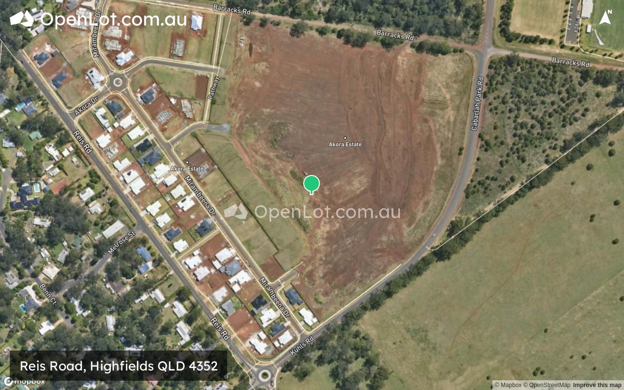
Reis Road, Highfields QLD 4352 IN PLANNING
Vacant land
House and land
The information provided in relation to this development has been obtained from publicly available sources and has not been verified or in any way endorsed by the developer. OpenLot.com.au has not been authorised by the developer to market this land estate on behalf of the developer or the vendors or any other third party.
If you're the developer or authorised agent, contact us now to activate your project.
This information is estimated by the OpenLot research team. Let us know here to provide up-to-date information about this development.
| Total new homes | 221 |
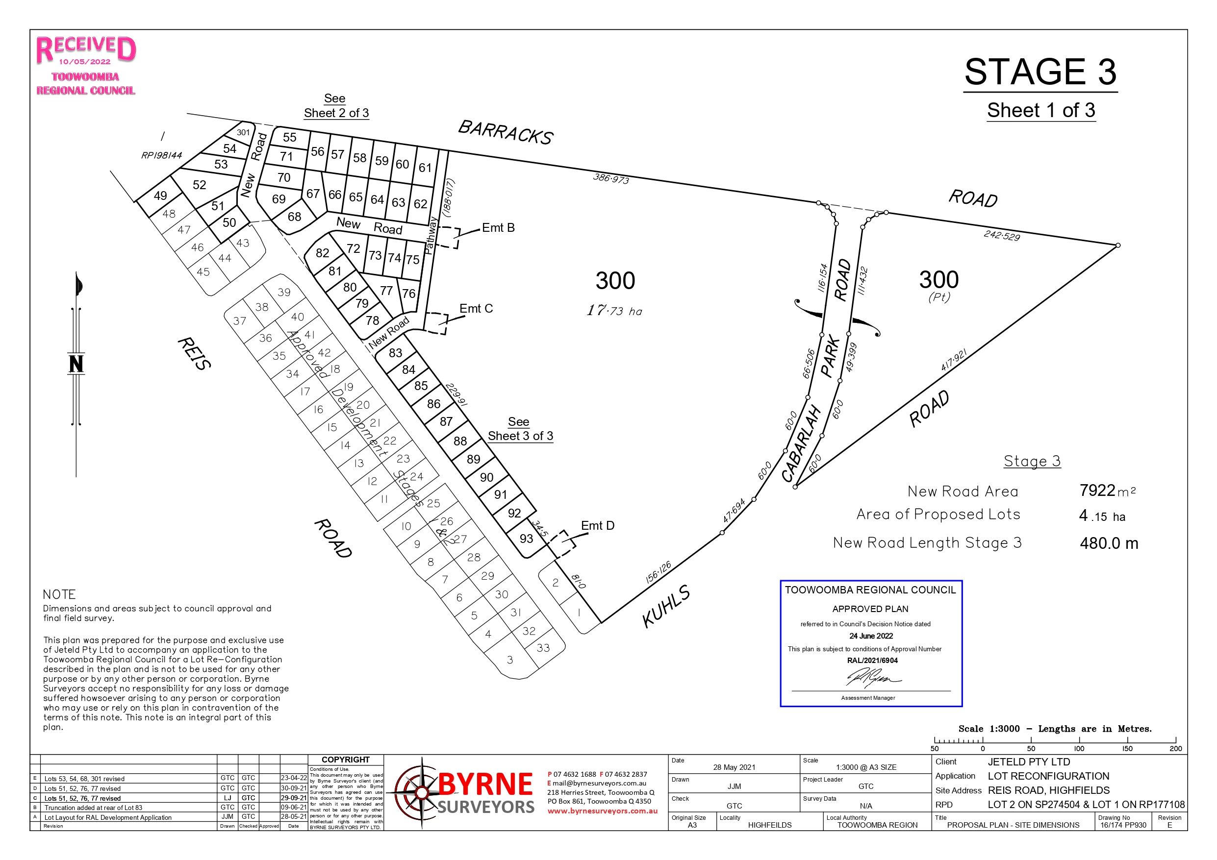
| Area size | 28.70 hectares |
| Growth Region | Toowoomba Growth Areas |
| City council | Toowoomba Regional Council |
| Developer | N/A |
| Project marketer | Clive Berghofer Group |
| Distance to | Toowoomba CBD - 17 km north-east |
Land for Sale, House and Land Packages:
Popular Estates near Reis Road, Highfields


Updates for Reis Road, Highfields
Facebook updates:
Location & Map for Reis Road, Highfields
Visit Display Homes near Reis Road, Highfields

Vacancy Rate in Highfields QLD 4352
View full vacancy rate history in Highfields QLD 4352 via SQM Research.
Schools near Reis Road, Highfields
Here are 6 schools near Reis Road, Highfields:
7-12 Government Secondary School
Prep-6 Government Primary School
Prep-12 Catholic Combined School
Prep-12 Independent Combined School
Prep-6 Government Primary School
Prep-6 Government Primary School
Reviews & Comments on Reis Road, Highfields
Estate Brochure, Masterplan, Engineering Plan, Plan of Subdivision (POS), Design Guidelines
FAQs about Reis Road, Highfields
View all estates marketed by Clive Berghofer Group
- Highfields State Secondary College - 911m west
- Highfields State School - 1.6km south
- Mary MacKillop Catholic College - 1.7km west
- Toowoomba Christian College - 4.7km south
- Meringandan State School - 5.8km west
- Geham State School - 5.9km north-east
Popular Estates near Reis Road, Highfields
Latest New Home Articles for You

09/Mar/2026 | OpenLot.com.au
Victoria: Top 30 Most Searched Housing Developments (February 2026)
If you’ve been exploring housing opportunities in Victoria, February 2026...

20/Feb/2026 | OpenLot.com.au
Display Homes at Drouin Fields Estate: A Thriving Community in Drouin
Welcome to Drouin Fields, a place where beauty, space, and modern luxury ...

19/Feb/2026 | OpenLot.com.au
Display Homes at Manor Lakes Esate: A Thriving Waterside Community in Manor Lakes
A place where you can settle in, rather than just settle down. Named for ...

13/Feb/2026 | OpenLot.com.au
🏠 Victoria: Top 30 Most Searched Townhouse Developments – January 2026

11/Feb/2026 | OpenLot.com.au
🏡 Top 30 Most Searched Estates by State - January 2026

10/Feb/2026 | OpenLot.com.au
Victoria: Top 30 Most Searched Housing Developments (January 2026)
If you’ve been considering making a move in Victoria, January 2026 offere...

10/Feb/2026 | OpenLot.com.au
Queensland: Top 30 Most Searched Housing Developments (January 2026)
If you’ve been considering making a move in Queensland, January 2026 offe...

09/Feb/2026 | OpenLot.com.au
Western Australia: Top 30 Most Searched Housing Developments (January 2026)
If you’ve been considering making a move in Western Australia, January 20...

06/Feb/2026 | OpenLot.com.au
South Australia: Top 30 Most Searched Housing Developments (January 2026)
If you’ve been considering making a move in South Australia, January 2026...