

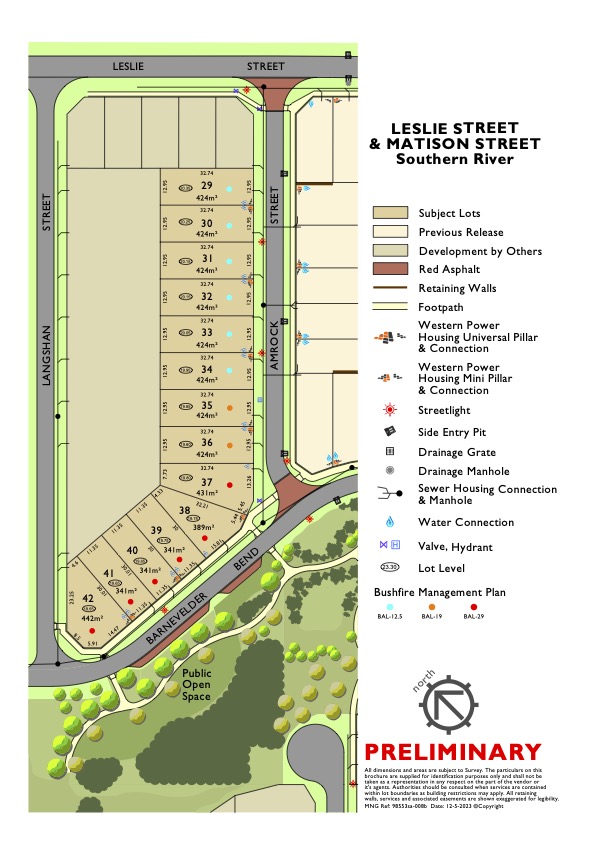

Sapphire Estate - Southern River SOLD OUT
This information is estimated by the OpenLot research team. Let us know here to provide up-to-date information about this development.
| Total new homes | 28 |
| Area size | 1.93 hectares |
| Growth Region | Perth South East Growth Areas |
| City council | City of Gosnells |
| Developer | Progress Developments |
Land for Sale, House and Land Packages:
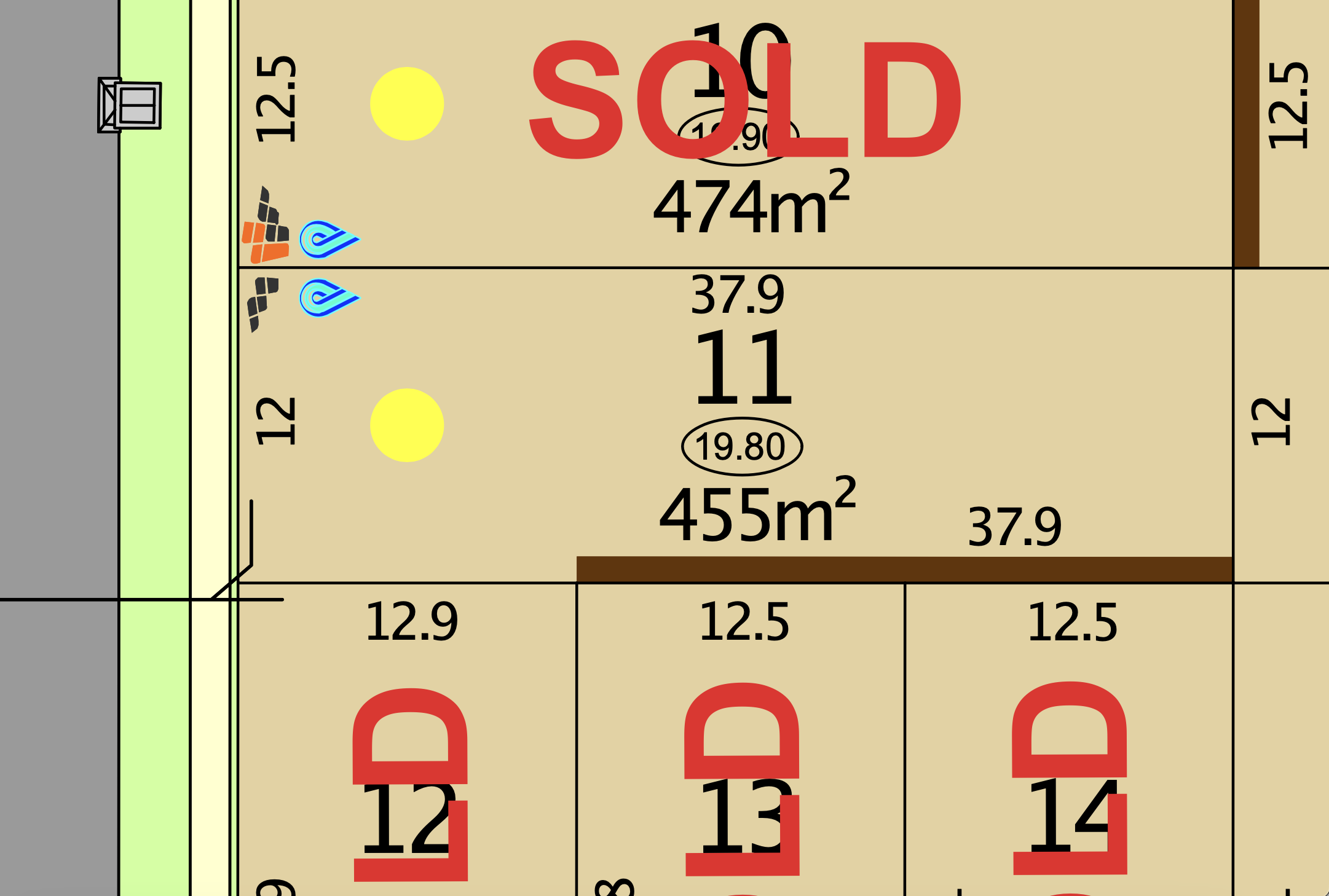
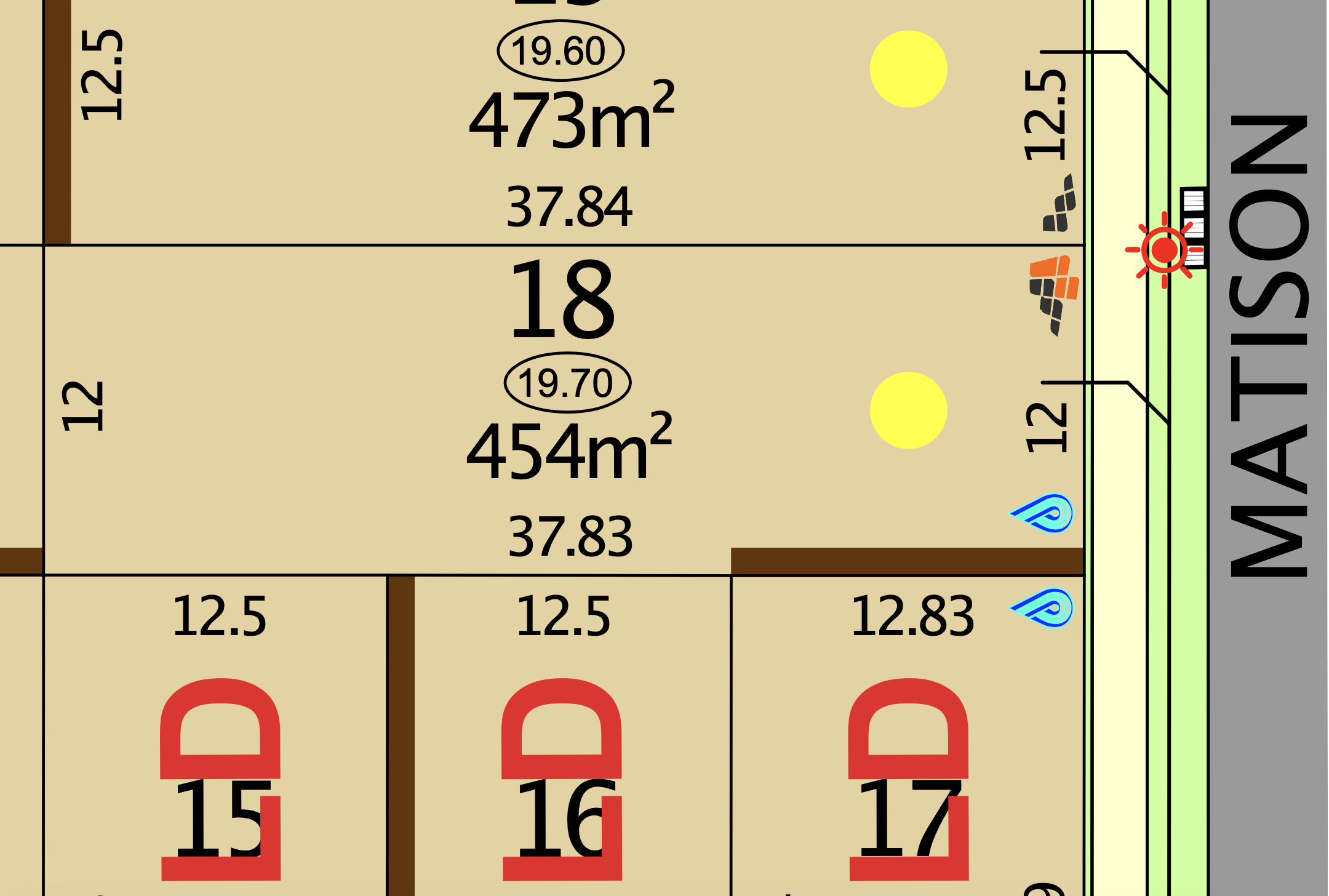
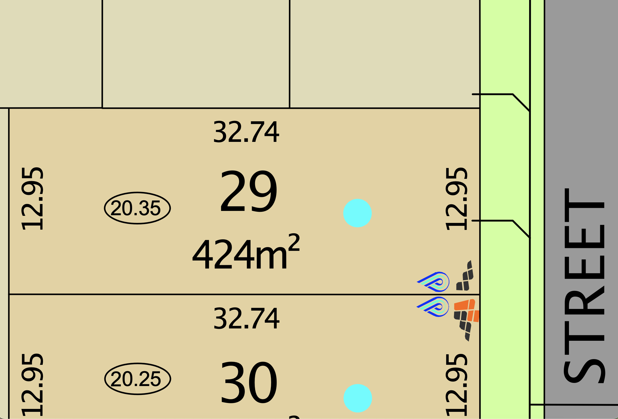
10 Land Lots in Sapphire Estate - Southern River


Popular Estates near Sapphire Estate - Southern River


Updates for Sapphire Estate - Southern River
Facebook updates:
Submit the Facebook page for Sapphire Estate - Southern River.
Related news:
Missing articles? Send us a link here.
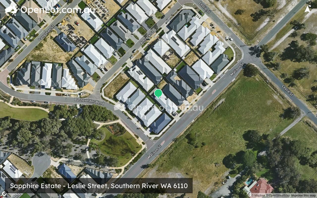
Location & Map for Sapphire Estate - Southern River
Visit Display Homes near Sapphire Estate - Southern River


Vacancy Rate in Southern River WA 6110
View full vacancy rate history in Southern River WA 6110 via SQM Research.
Schools near Sapphire Estate - Southern River
Here are 6 schools near Sapphire Estate - Southern River:
K-6 Government Primary School
K-6 Government Primary School
7-12 Government Secondary School
K-6 Government Primary School
PP-6 Catholic Primary School
K-6 Government Primary School
Suburb Planning Review in Southern River WA 6110
Southern River is located within the City of Gosnells, located 21 kilometres west of South-East of Perth CBD. Southern River is approximately 14.7 square kilometres, which is bounded by Tonkin Highway to the east, Warton Road to the west, Verna Street, Fremantle Road and Ranford Road to the north, with Warton Road and Nicholson Road to the south.
The Western Australian Planning Commission named the suburb in 2002 under the direction of the Minister for Planning in the Western Australian State Government. along with 33 new suburbs in Western Australia on 20 December 2002. These new suburbs were given official names and boundaries were chosen by the Western Australian Land Information Authority (Landgate).

Southern River, Forrestdale, Brookdale, Wungong District Structure Plan The Southern River, Forrestdale, Brookdale, Wungong area poses planning challenges due to various factors including a high water table, contaminated sites, offsite impacts from poultry farms and kennels, major infrastructure installations (power lines, gas and water mains), conservation and environmental sites, and land fragmentation. To address these concerns, the Western Australian Planning Commission, in collaboration with the Cities of Gosnells and Armadale and key stakeholders, has prepared the Southern River/Forrestdale/Brookdale/Wungong District Structure Plan. This structure plan was published on 11 August 2021 by the WA Department of Planning, Lands and Heritage.
Southern River, WA falls within the jurisdiction of the City of Gosnells. The area is governed by the City's Local Planning Scheme No. 26 (Amendment 110), which was approved by the Minister of Planning and published in the Government Gazette on 3 May 2022. A report regarding this scheme was presented to the council during their Ordinary Council Meeting on 26 July 2022.
Southern River contains zones that maintain the development intentions of the City of Gosnells Local Planning Scheme No. 24. Residential Zones are spread throughout Southern River, encompassing various housing developments and estates. The primary business (commercial) zone is located around the Southern River Shopping Centre near the centre of the suburb providing a range of retail stores, restaurants, and services.
A mix of rural, park and recreation zoning are located to the southern boundaries, with further rural zoning location along the eastern boundary. A large recreation-zoned area is located to the northwest and surrounded by residential development
Industrial Zones: Industrial areas in Southern River can be found towards the southeast part of the suburb, closer to Tonkin Highway and Rowley Road. These areas may include warehouses, factories, and other industrial facilities.

The plan aligns with the City's Local Planning Policy 3.3 - Southern River Precinct 3 Planning Framework, which guides the preparation of amendments, structure plans, and development contribution plans to provide shared infrastructure and public land.
The Southern River suburb is subject to the Southern River District Structure Plan, which was prepared by the Western Australian Planning Commission (WAPC) in 2004. The structure plan serves as a guiding document for the development and land use within the Southern River district, outlining the vision, objectives, and strategies for future growth and development in the area.
The Southern River District Structure Plan was subsequently amended in 2014, following a review by the WAPC. The amended plan was approved by the Minister for Planning in 2015 and is the current version in effect for the area.
Structure plans have been prepared and approved over recent years for Precincts 3A North, 3A South, 3B (part), 3C (part), 3D (part), 3E, and 3F.
- Southern River has undergone significant development over the past few decades, with the Gosnells Council providing a range of physical and social infrastructure to support the growing community. Some of the key infrastructure that has been provided in Southern River includes:
- Schools: Southern River is home to several schools, including Southern River College, Bletchley Park Primary School, and Carey Baptist College.
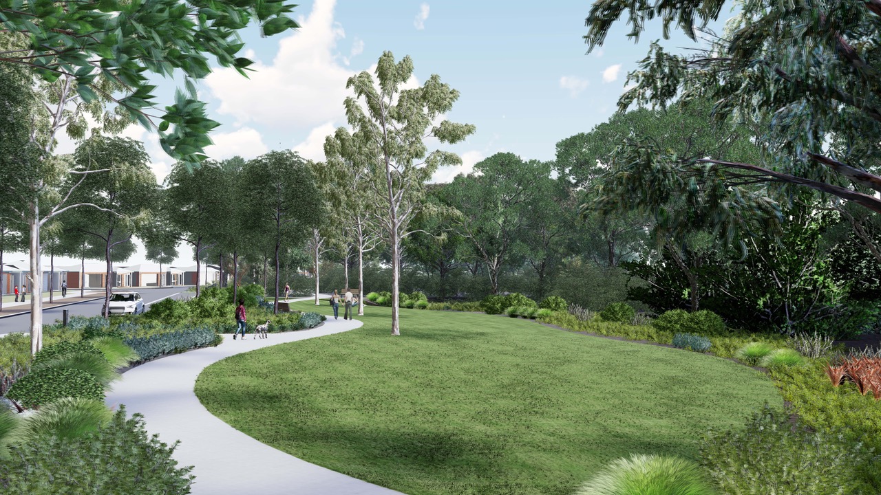
- Parks and open space: Southern River has a range of parks and reserves, including the Bletchley Park Estate, Sutherlands Park, and the Southern River Foreshore Reserve. These areas provide opportunities for recreational activities such as walking, cycling, picnicking, and sports.
- Community facilities: The suburb has a range of community facilities, including a community center, a library, and a range of local shops and restaurants.
- Transport infrastructure: Southern River is well connected to major roads such as Ranford Road, Southern River Road, and Tonkin Highway, which provide access to the wider Perth metropolitan area. The suburb is also serviced by bus routes that connect to nearby train stations.
In addition to the existing infrastructure, there are ongoing plans for further development and redevelopment in Southern River. Some notable examples include:
- Redevelopment of the former Boral brickworks site: This redevelopment project is expected to bring additional housing, commercial, and recreational facilities to Southern River, contributing to the growth and enhancement of the area.
- Local traffic management and public transport improvements: The City of Gosnells is working on plans to improve local traffic management and public transport services in Southern River, aiming to enhance transportation options and alleviate congestion.
- Sustainability initiatives: The City of Gosnells is also focused on enhancing the sustainability of the suburb. This includes initiatives such as the installation of solar panels to promote renewable energy usage and the promotion of cycling and walking to encourage active transportation and reduce reliance on cars.
These ongoing plans for development, traffic management, public transport, and sustainability demonstrate the commitment of the City of Gosnells to further enhance Southern River and meet the evolving needs of the community.
Local Planning Strategy of Southern River
The Local Planning Strategy is a strategic urban land use document that assists the City of Gosnells in planning for future growth. It establishes the City's objectives for future development through a comprehensive framework that promotes coordinated and sustainable growth.
In line with other urban planning documents, the strategy takes into account environmental, economic, and social factors, as well as census data and community input. It provides a clear vision for various aspects, including housing, transportation, and employment.
The Local Planning Strategy is a compilation of several sub-planning strategies, such as the Activity Centres Planning Strategy, Foothills Rural Strategy, Local Housing Strategy, Public Open Space Strategy, and Heritage Strategy. These sub-strategies contribute to the overall planning framework.
The strategy was endorsed by the council on 23 February 2021 and has been submitted to the Western Australian Planning Commission for final approval by the Minister for Planning. This process
ensures that the strategy aligns with the broader planning guidelines and regulations. The City has developed the Local Planning Strategy from several sub-planning strategies including:
- Activity Centres Planning Strategy
- Foothills Rural Strategy
- Local Housing Strategy
- Public Open Space Strategy
- Heritage Strategy
Southern River Growth Suburb Summary
References
- City of Gosnells – Town Planning Scheme No.6
Development Contribution Plan - Southern River Precinct 1 Development Contribution Plan - Southern River Precinct 2
Development Contribution Plan - Southern River Precinct 3 Southern River Precinct 1 Outline Development Plan
Southern River Precinct 2 ODP
Southern River Precinct 2 Phase 3 Structure Plan Southern River Precinct 3 D Structure Plan
Southern River Precinct 3A (North) ODP
Southern River Precinct 3A (South) ODP
Southern River Precinct 3C (South) Structure Plan Southern River Precinct 3Cii (Central) Structure Plan Southern River Precinct 3E Structure Plan
- Southern River Precinct 3F Structure Plan
- Southern River Precinct 5 ODP
Reviews & Comments on Sapphire Estate - Southern River
Estate Brochure, Masterplan, Engineering Plan, Plan of Subdivision (POS), Design Guidelines
FAQs about Sapphire Estate - Southern River
View all estates from Progress Developments
- Yarralinka Primary School - 687m south-west
- Ashburton Drive Primary School - 1.6km north-east
- Southern River College - 1.6km north
- Southern Grove Primary School - 1.8km west
- St Munchin's Catholic School - 2.1km north-east
- Seaforth Primary School - 2.3km north-east
Popular Estates near Sapphire Estate - Southern River
Latest New Home Articles for You

09/Mar/2026 | OpenLot.com.au
Victoria: Top 30 Most Searched Housing Developments (February 2026)
If you’ve been exploring housing opportunities in Victoria, February 2026...

20/Feb/2026 | OpenLot.com.au
Display Homes at Drouin Fields Estate: A Thriving Community in Drouin
Welcome to Drouin Fields, a place where beauty, space, and modern luxury ...

19/Feb/2026 | OpenLot.com.au
Display Homes at Manor Lakes Esate: A Thriving Waterside Community in Manor Lakes
A place where you can settle in, rather than just settle down. Named for ...

13/Feb/2026 | OpenLot.com.au
🏠 Victoria: Top 30 Most Searched Townhouse Developments – January 2026

11/Feb/2026 | OpenLot.com.au
🏡 Top 30 Most Searched Estates by State - January 2026

10/Feb/2026 | OpenLot.com.au
Victoria: Top 30 Most Searched Housing Developments (January 2026)
If you’ve been considering making a move in Victoria, January 2026 offere...

10/Feb/2026 | OpenLot.com.au
Queensland: Top 30 Most Searched Housing Developments (January 2026)
If you’ve been considering making a move in Queensland, January 2026 offe...

09/Feb/2026 | OpenLot.com.au
Western Australia: Top 30 Most Searched Housing Developments (January 2026)
If you’ve been considering making a move in Western Australia, January 20...

06/Feb/2026 | OpenLot.com.au
South Australia: Top 30 Most Searched Housing Developments (January 2026)
If you’ve been considering making a move in South Australia, January 2026...