
Seabreeze Estate - Port Wakefield
 1 Balaklava Road, Port Wakefield SA 5550
This information is estimated by the OpenLot research team. Let us know here to provide up-to-date information about this development.
| Total new homes | N/A |
| Area size | 36.75 hectares |
| City council | Wakefield Regional Council |
| Developer | N/A |
| Project marketer | Ray White North Adelaide |
| Distance to | Adelaide CBD - 92 km north-west |
Land for Sale, House and Land Packages:
Popular Estates near Seabreeze Estate - Port Wakefield


Updates for Seabreeze Estate - Port Wakefield
Facebook updates:
Submit the Facebook page for Seabreeze Estate - Port Wakefield.
Related news:
'You Can Feel the Seabreeze!' - Listed by Ray White North Adelaide

Missing articles? Send us a link here.
Location & Map for Seabreeze Estate - Port Wakefield
Vacancy Rate in Port Wakefield SA 5550
View full vacancy rate history in Port Wakefield SA 5550 via SQM Research.
Schools near Seabreeze Estate - Port Wakefield
Here are 6 schools near Seabreeze Estate - Port Wakefield:
R-7 Government Primary School
R-12 Independent Combined School
U, 7-12 Government Secondary School
U, R-6 Government Primary School
R-12 Government Combined School
R-6 Government Primary School
Reviews & Comments on Seabreeze Estate - Port Wakefield
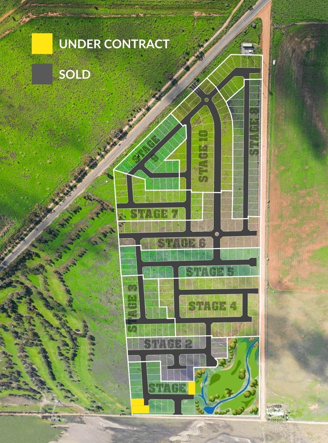
Estate Brochure, Masterplan, Engineering Plan, Plan of Subdivision (POS), Design Guidelines
FAQs about Seabreeze Estate - Port Wakefield
View all estates marketed by Ray White North Adelaide
- Port Wakefield Primary School - 1.6km south-west
- Horizon Christian School - 23.2km east
- Balaklava High School - 23.3km east
- Balaklava Primary School - 23.4km east
- Ardrossan Area School - 35.3km south-west
- Owen Primary School - 36.3km east
Popular Estates near Seabreeze Estate - Port Wakefield
Latest New Home Articles for You

26/Jul/2024
Your next Investment Property Can Now Return 10%+
Find out How A ‘Multi-Liv’ Property Returns on Average $7,350 per mont...

26/Jul/2024
Deciphering the Tactics Behind Builder Promotions for Informed Decision-Making
In the labyrinthine world of home building, the allure of promotions can ...

18/Jul/2024
Display Homes at Ferntree Ridge: Embrace Country Living in Drouin
Ferntree Ridge by LandGipps, offers a unique opportunity to experience th...

15/Jul/2024
How to Finance Your House and Land Package
Financing a house and land package involves understanding various options...

09/Jul/2024
Display Homes at Kinley Lilydale: A New Era of Living
Intrapac Property's latest development, Kinley, is set to transform Lilyd...

09/Jul/2024
Victoria: Top 30 Most Searched Housing Developments (June 2024)
We're excited to unveil the lineup of the top 30 most searched housing de...

09/Jul/2024
Western Australia: Top 30 Most Searched Housing Developments (June 2024)
If you've ever dreamt of making Western Australia your home, now is the p...

09/Jul/2024
South Australia: Top 30 Most Searched Housing Developments (June 2024)
South Australia, with its captivating allure and rich cultural heritage, ...

09/Jul/2024
Queensland: Top 30 Most Searched Housing Developments (June 2024)
On Australia's sun-kissed eastern coast lies Queensland, often referred t...