Wirraway Estate - Thornton SOLD OUT
This information is estimated by the OpenLot research team. Let us know here to provide up-to-date information about this development.
| Total new homes | 511 |
| Area size | 58.00 hectares |
| Growth Region | Greater Newcastle Growth Areas (The Hunter Region) |
| City council | Maitland City Council |
| Developer | Defence Housing Australia |
| Distance to | Newcastle CBD - 21 km north-west |
Land for Sale, House and Land Packages:
Popular Estates near Wirraway Estate - Thornton


 5
5
 3
3
 2
2


Updates for Wirraway Estate - Thornton
Facebook updates:
Related news:
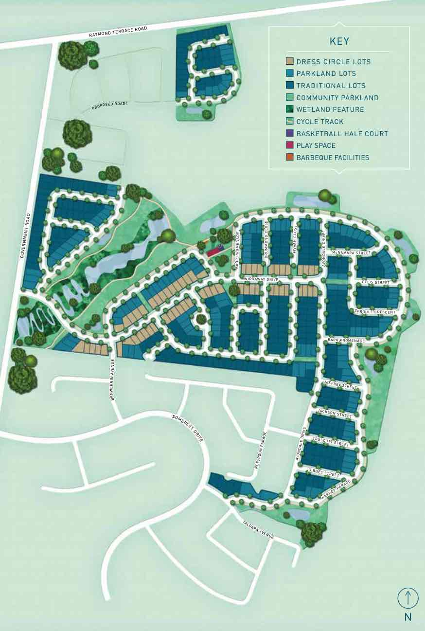
Wirraway will feature 506 residences, with DHA building 50 per cent of the properties for Defence members and their families. The remaining land lots will be sold to the public.
Since beginning the Wirraway Thornton development project in 2014 for Defence Housing Australia (DHA), Daracon has constructed all stages of the subdivision’s master plan that spans over 58 hectares and 511 lots.

Missing articles? Send us a link here.
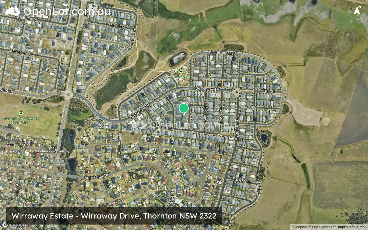
Location & Map for Wirraway Estate - Thornton
Visit Display Homes near Wirraway Estate - Thornton


Vacancy Rate in Thornton NSW 2322
View full vacancy rate history in Thornton NSW 2322 via SQM Research.
Schools near Wirraway Estate - Thornton
Here are 6 schools near Wirraway Estate - Thornton:
K-6 Government Primary School
U Independent Special School - School Head Campus
K-6 Catholic Primary School
7-12 Catholic Secondary School
U Government Special School
K-6 Government Primary School
Reviews & Comments on Wirraway Estate - Thornton
Estate Brochure, Masterplan, Engineering Plan, Plan of Subdivision (POS), Design Guidelines
FAQs about Wirraway Estate - Thornton
View all estates from Defence Housing Australia
- Thornton Public School - 1.8km south-west
- Aspect Hunter School - 2.2km south-west
- St Aloysius Catholic Primary School - 2.6km north-west
- St Bede's Catholic College - 2.7km north-west
- Woodberry Learning Centre - 2.8km south-east
- Woodberry Public School - 2.8km south-east
Popular Estates near Wirraway Estate - Thornton
Latest New Home Articles for You

09/Mar/2026 | OpenLot.com.au
Victoria: Top 30 Most Searched Housing Developments (February 2026)
If you’ve been exploring housing opportunities in Victoria, February 2026...

20/Feb/2026 | OpenLot.com.au
Display Homes at Drouin Fields Estate: A Thriving Community in Drouin
Welcome to Drouin Fields, a place where beauty, space, and modern luxury ...

19/Feb/2026 | OpenLot.com.au
Display Homes at Manor Lakes Esate: A Thriving Waterside Community in Manor Lakes
A place where you can settle in, rather than just settle down. Named for ...

13/Feb/2026 | OpenLot.com.au
🏠 Victoria: Top 30 Most Searched Townhouse Developments – January 2026

11/Feb/2026 | OpenLot.com.au
🏡 Top 30 Most Searched Estates by State - January 2026

10/Feb/2026 | OpenLot.com.au
Victoria: Top 30 Most Searched Housing Developments (January 2026)
If you’ve been considering making a move in Victoria, January 2026 offere...

10/Feb/2026 | OpenLot.com.au
Queensland: Top 30 Most Searched Housing Developments (January 2026)
If you’ve been considering making a move in Queensland, January 2026 offe...

09/Feb/2026 | OpenLot.com.au
Western Australia: Top 30 Most Searched Housing Developments (January 2026)
If you’ve been considering making a move in Western Australia, January 20...

06/Feb/2026 | OpenLot.com.au
South Australia: Top 30 Most Searched Housing Developments (January 2026)
If you’ve been considering making a move in South Australia, January 2026...