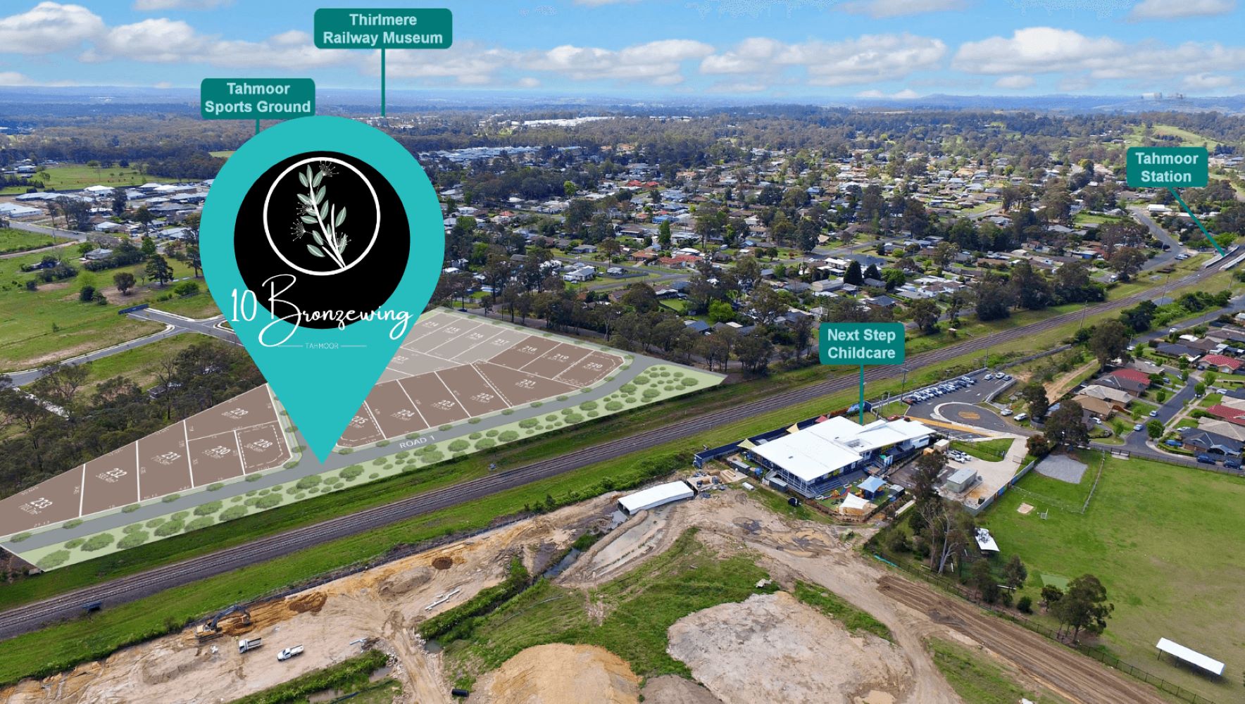


10-22 Bronzewing Street, Tahmoor NSW 2573
This information is estimated by the OpenLot research team. Let us know here to provide up-to-date information about this development.
| Total new homes | 20 |
| Area size | N/A |
| Growth Region | Sydney South West Growth Areas |
| City council | Wollondilly Shire Council |
| Developer | N/A |
| Project marketer | Avera Property Group |
| Distance to | Sydney CBD - 68 km south-west |
Land for Sale, House and Land Packages:
Popular Estates near 10-22 Bronzewing Street, Tahmoor

Bingara Gorge Estate - Wilton

The River Estate - Tahmoor

The Acres Wollondilly Estate - Tahmoor

Belford Park Estate - Tahmoor

The Gardens Estate - Tahmoor

Myrtle Estate - Tahmoor

Cross Street Estate - Tahmoor

50 Tahmoor Road, Tahmoor NSW 2573

45 Major Roberts Avenue, Tahmoor NSW 2573
Updates for 10-22 Bronzewing Street, Tahmoor
Facebook updates:
Submit the Facebook page for 10-22 Bronzewing Street, Tahmoor.
Related news:
Missing articles? Send us a link here.
Location & Map for 10-22 Bronzewing Street, Tahmoor
Vacancy Rate in Tahmoor NSW 2573
View full vacancy rate history in Tahmoor NSW 2573 via SQM Research.
Schools near 10-22 Bronzewing Street, Tahmoor
Here are 6 schools near 10-22 Bronzewing Street, Tahmoor:
K-6 Government Primary School
K-12 Independent Combined School
K-6 Government Primary School
7-12 Government Secondary School
K-6 Government Primary School
K-6 Government Primary School
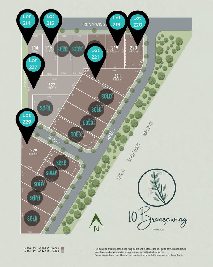
Land Release Applications for 10-22 Bronzewing Street, Tahmoor
| Land release | Land report | Number of lots | Plan number | Land surveyor | Lodged date | Intended use | Settlement tracking | |||||||||||||||||||||||||||||||||||||||||||||||||||||||||||||||||||||||||||||||||||||||||||
|---|---|---|---|---|---|---|---|---|---|---|---|---|---|---|---|---|---|---|---|---|---|---|---|---|---|---|---|---|---|---|---|---|---|---|---|---|---|---|---|---|---|---|---|---|---|---|---|---|---|---|---|---|---|---|---|---|---|---|---|---|---|---|---|---|---|---|---|---|---|---|---|---|---|---|---|---|---|---|---|---|---|---|---|---|---|---|---|---|---|---|---|---|---|---|---|---|---|---|
| No updates found |
Reviews & Comments on 10-22 Bronzewing Street, Tahmoor
Estate Brochure, Masterplan, Engineering Plan, Plan of Subdivision (POS), Design Guidelines
FAQs about 10-22 Bronzewing Street, Tahmoor
View all estates marketed by Avera Property Group
- Tahmoor Public School - 305m east
- Wollondilly Anglican College - 463m east
- Thirlmere Public School - 2.9km north-west
- Picton High School - 4.2km north-east
- Buxton Public School - 4.3km south-west
- Picton Public School - 6.1km north
Popular Estates near 10-22 Bronzewing Street, Tahmoor
Bingara Gorge Estate - Wilton
The River Estate - Tahmoor
The Acres Wollondilly Estate - Tahmoor
Belford Park Estate - Tahmoor
The Gardens Estate - Tahmoor
Myrtle Estate - Tahmoor
Cross Street Estate - Tahmoor
50 Tahmoor Road, Tahmoor NSW 2573
45 Major Roberts Avenue, Tahmoor NSW 2573
Latest New Home Articles for You

30/Apr/2024
The Power of Co Living Investing
In the latest episode of The Property Now Podcast, hosts Matt Ellul and B...

29/Apr/2024
Titled Land vs Non-titled Land - Which is better?
In the latest episode of the Home Building Hub podcast, hosts Colin Bisch...

26/Apr/2024
Navigating the Path to Homeownership: Insights from Home Loan Expert
The lates episode of Home Builder Hub sets the stage for an insightful co...

24/Apr/2024
Delving into Design and Structural Changes: Balancing Risk and Reward
In a recent episode of their podcast, hosts Colin Bischof and Darren Bren...

23/Apr/2024
The Property Now Podcast: Using Your Super to Buy Property Like Never Before
In an innovative episode of the esteemed series, hosts Matt Ellul and Bob...

22/Apr/2024
Should Home Buyers Act Before Seven-Star Pricing Kicks In?
In the latest episode of *The Home Building Hub*, hosts Colin Bischof and...

22/Apr/2024
How to Determine Which House Design Will Fit on Your Lot
In the latest episode of the Home Building Hub podcast, hosts Colin Bisch...

15/Apr/2024
Navigating the Intricacies of Nomination Blocks
In a recent episode of the Home Building Hub podcast, hosted by industry ...

10/Apr/2024
How Do Mortgages Work?
What is a mortgage broker? How does a mortgage broker get paid? Licensing...