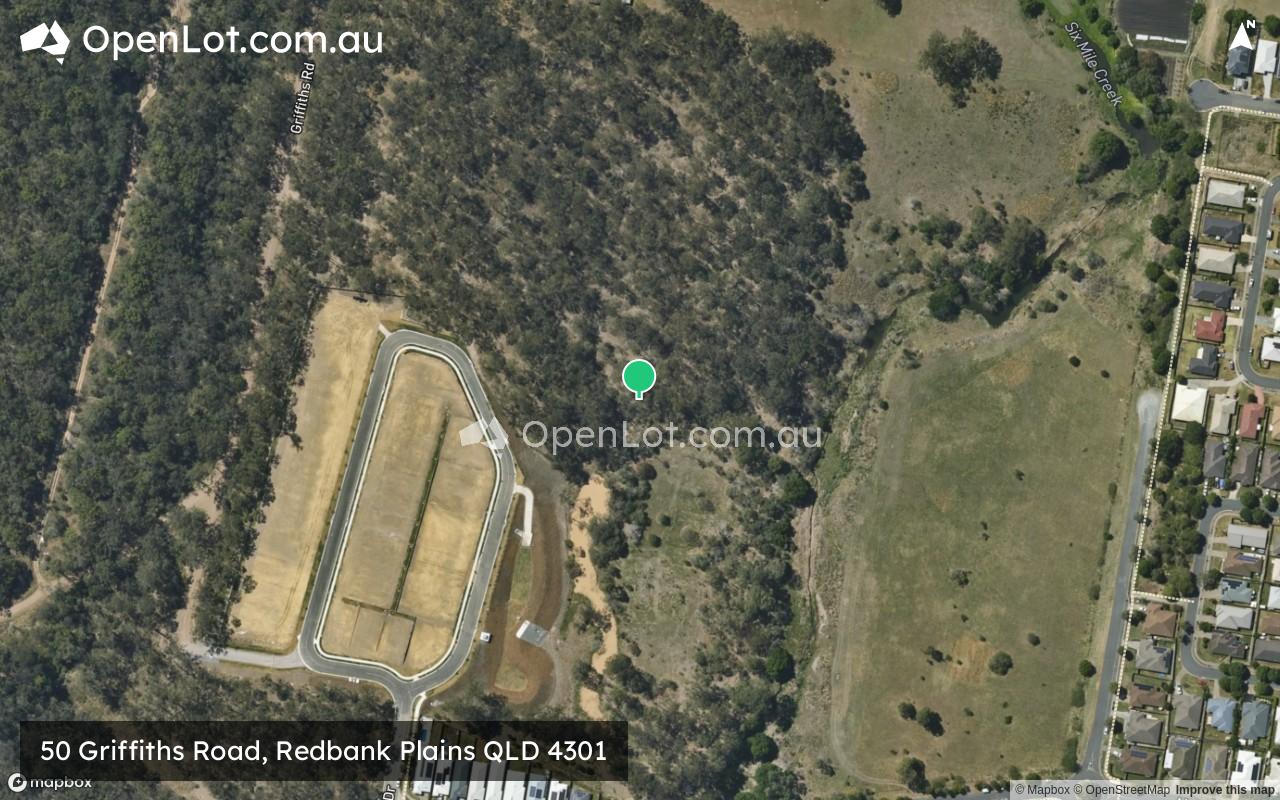
50 Griffiths Road, Redbank Plains QLD 4301 IN PLANNING
This information is estimated by the OpenLot research team. Let us know here to provide up-to-date information about this development.
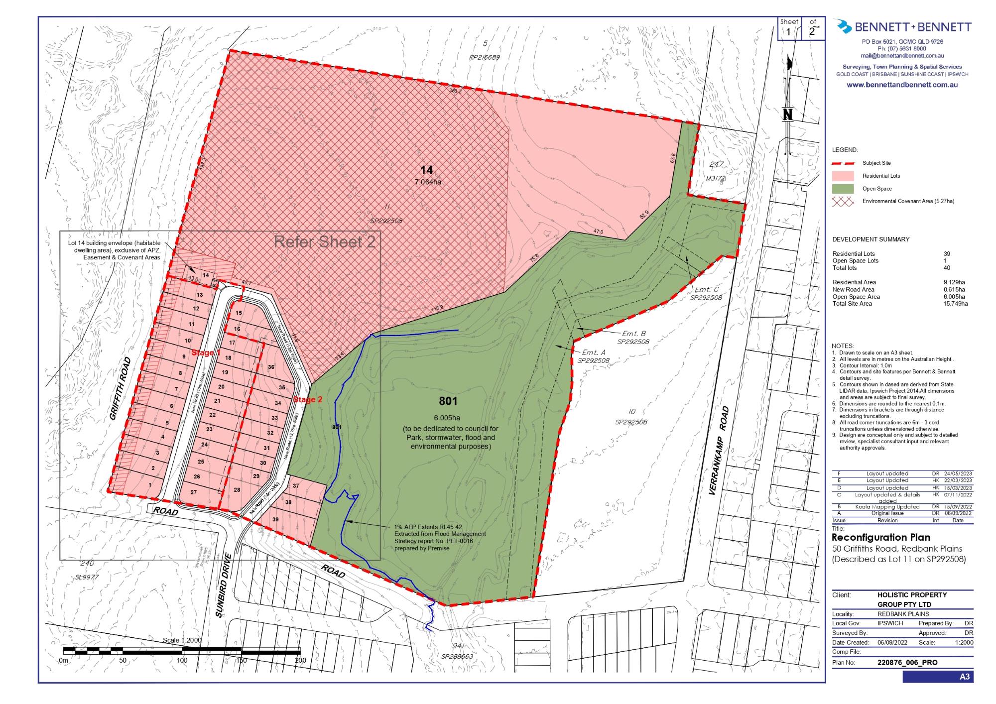
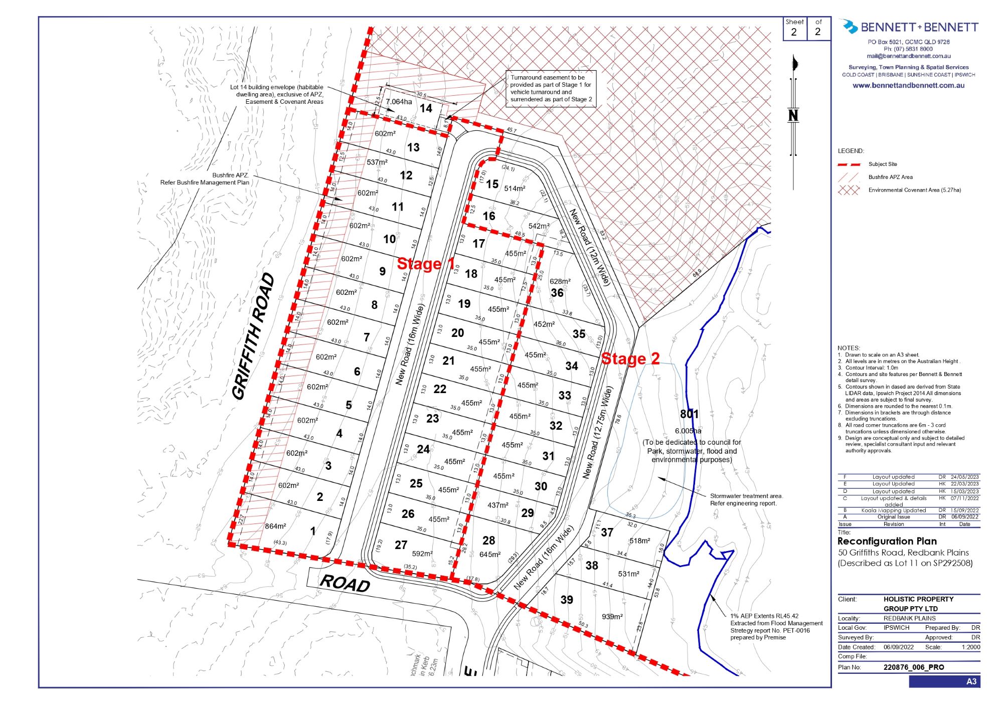
| Total new homes | 39 |
| Area size | 15.62 hectares |
| Growth Region | Greater Brisbane Growth Areas |
| City council | Ipswich City Council |
| Developer | N/A |
| Distance to | Brisbane CBD - 27 km south-west Brisbane Airport - 40 km south-west |
Land for Sale, House and Land Packages:
Popular Estates near 50 Griffiths Road, Redbank Plains


Updates for 50 Griffiths Road, Redbank Plains
Facebook updates:
Submit the Facebook page for 50 Griffiths Road, Redbank Plains.
Location & Map for 50 Griffiths Road, Redbank Plains
Visit Display Homes near 50 Griffiths Road, Redbank Plains


Vacancy Rate in Redbank Plains QLD 4301
View full vacancy rate history in Redbank Plains QLD 4301 via SQM Research.
Schools near 50 Griffiths Road, Redbank Plains
Here are 6 schools near 50 Griffiths Road, Redbank Plains:
Prep-6 Catholic Primary School
Prep-6 Government Primary School
Prep-6 Government Primary School
Prep-12 Independent Combined School
Prep-6 Government Primary School
7-12 Government Secondary School
Reviews & Comments on 50 Griffiths Road, Redbank Plains
Estate Brochure, Masterplan, Engineering Plan, Plan of Subdivision (POS), Design Guidelines
FAQs about 50 Griffiths Road, Redbank Plains
- St Ann's School - 621m north-east
- Fernbrooke State School - 922m south-east
- Redbank Plains State School - 1.3km north-east
- Staines Memorial College - 2.0km south-east
- WoodLinks State School - 2.9km north-east
- Redbank Plains State High School - 2.9km east
Popular Estates near 50 Griffiths Road, Redbank Plains
Latest New Home Articles for You

09/Mar/2026 | OpenLot.com.au
Victoria: Top 30 Most Searched Housing Developments (February 2026)
If you’ve been exploring housing opportunities in Victoria, February 2026...

20/Feb/2026 | OpenLot.com.au
Display Homes at Drouin Fields Estate: A Thriving Community in Drouin
Welcome to Drouin Fields, a place where beauty, space, and modern luxury ...

19/Feb/2026 | OpenLot.com.au
Display Homes at Manor Lakes Esate: A Thriving Waterside Community in Manor Lakes
A place where you can settle in, rather than just settle down. Named for ...

13/Feb/2026 | OpenLot.com.au
🏠 Victoria: Top 30 Most Searched Townhouse Developments – January 2026

11/Feb/2026 | OpenLot.com.au
🏡 Top 30 Most Searched Estates by State - January 2026

10/Feb/2026 | OpenLot.com.au
Victoria: Top 30 Most Searched Housing Developments (January 2026)
If you’ve been considering making a move in Victoria, January 2026 offere...

10/Feb/2026 | OpenLot.com.au
Queensland: Top 30 Most Searched Housing Developments (January 2026)
If you’ve been considering making a move in Queensland, January 2026 offe...

09/Feb/2026 | OpenLot.com.au
Western Australia: Top 30 Most Searched Housing Developments (January 2026)
If you’ve been considering making a move in Western Australia, January 20...

06/Feb/2026 | OpenLot.com.au
South Australia: Top 30 Most Searched Housing Developments (January 2026)
If you’ve been considering making a move in South Australia, January 2026...