

Adore Estate - Mount Barker SOLD OUT
This information is estimated by the OpenLot research team. Let us know here to provide up-to-date information about this development.
| Total new homes | 64 |
| Area size | 4.40 hectares |
| Growth Region | Adelaide Hills Growth Areas |
| City council | Mount Barker District Council |
| Developer | Monopoly Property Group |
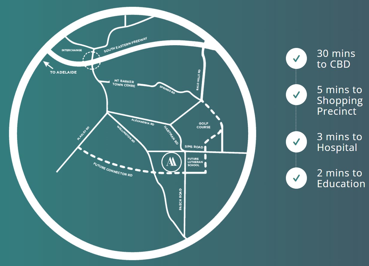
| Distance to | Adelaide CBD - 32 km south-east Adelaide Airport - 36 km south-east |
Land for Sale, House and Land Packages:
Popular Estates near Adore Estate - Mount Barker


 4
4
 2
2
 2
2


Updates for Adore Estate - Mount Barker
Facebook updates:
Related news:
This is "Adore Mt Barker 60sec" by writecall on Vimeo, the home for high quality videos and the people who love them.
Missing articles? Send us a link here.
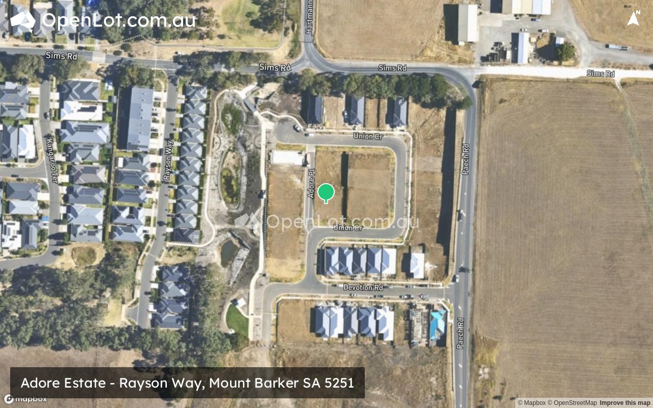
Location & Map for Adore Estate - Mount Barker
Visit Display Homes near Adore Estate - Mount Barker


Vacancy Rate in Mount Barker SA 5251
View full vacancy rate history in Mount Barker SA 5251 via SQM Research.
Schools near Adore Estate - Mount Barker
Here are 6 schools near Adore Estate - Mount Barker:
R-12 Independent Combined School
U, R-6 Government Primary School
R-6 Independent Primary School
R-12 Catholic Combined School
U, 7-12 Government Secondary School
U, R-6 Government Primary School
Suburb Planning Review in Mount Barker SA 5251
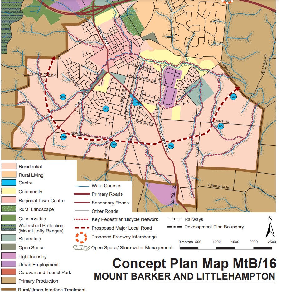
Mount Barker is a local town approximately 37.9 square kilometres in area, forming part of the Mount Lofty Ranges in the Greater Adelaide region of South Australia. Located 33 kilometres south east of Adelaide CBD, the semi-rural township contains a northern urbanised area, large local centre (commercial and retail), large industrial area, residential areas, wetlands, parks and schools. The urbanised area is surrounded by rural land holdings and the agriculture industry.

The suburb boundary is located along the Native Avenue, Pinchbeck Firetrack, Fidler Lane, Potts Road, Yunkunga Road and Merritt Road to the south. The South Eastern Freeway is the entire northern boundary, Springs Road, Harper Road and property boundaries to the to the east. Flaxley Road, Haines Firtrack, Liebelt Summer Track and properties boundaries provide the suburb boundary to the west.
A local road network is found throughout Mount Barker, providing access to the surrounding suburbs and the local network of roads. Springs Road and Old Mount Barkers Road provides west and east connections through the centre of the suburb, whilst Wellington Road, Flaxley Road and Bald Hills Road provides north and south connections linking to the major arterial road in proximity.

The northern urban area contains a mix of zoning that facilitates the community needs and services. The neighbourhood zone exists to the south of the business, retail and commercial zoning and provides exiting residential areas of the suburb.
The Master Planned Neighbourhood zoning was rezone under the Mount Barker Urban Growth Areas Development Plan (amendment) declared by the Minister for Planning in December 2010. The growth areas were reflected in the Development Plan prepared by Mount Barker District Council and the 30-Year Plan for Greater Adelaide prepared by the Department of Planning, Transport and Infrastructure for the South Australian State Government.
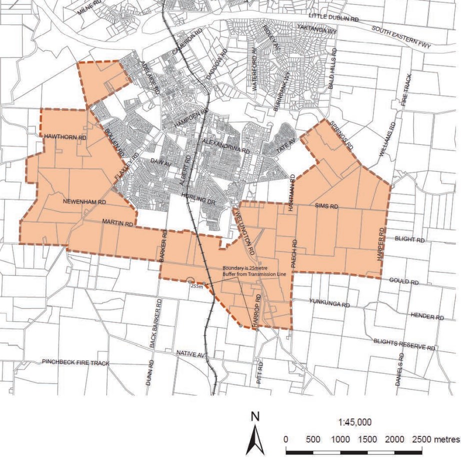
The rezone of Rural land to Residential under the Master Planned Neighbourhood zone affects approximately 1,200 hectares to accommodate a range of housing forms as well as a range of complementary services and activities to meet the needs of future residents. The rezone also included 42 hectares of land within the existing Light Industry Zone.
Mount Barker Submission for Managed Urban Growth
The plan for the next 30 years is the revitalisation of existing neighbourhoods, concentrated new development around transit corridors, and proposed new mixed-use precincts to bring jobs, services and public transport closer to where people live. The Mount Barker Council considered the growth area and provided the following position:
“Over the last ten years the District Council of Mount Barker has been the fastest growing non- coastal Council within Australia, averaging 3 per cent growth per annum. Through this experience Council has learnt invaluable lessons regarding managing and staging rapid growth and wishes to utilise this knowledge in the negotiation and provision of further growth. In the absence of strategies for community building, nor detail or commitment on how the infrastructure, health, education or social needs will be delivered or resourced; the rapid growth proposed in the draft 30 Year Plan threatens each pillar of sustainability and the values shared by the community. Council does not oppose population growth but will only support managed growth which is financially, socially and ecologically sustainable, and clearly resolves the critical issues outlined in Chapter 5 of this Submission”.
Mount Barker Strategic Vision
“The Mount Barker district will be recognised as being highly liveable, prosperous and safe, built from a foundation of community spirit and energy, quality of lifestyle and unique heritage, environment and landscape.” – Mount Barker 2035 District Strategic Plan.
Greater Adelaide Region Growth Area
The population growth in the Greater Adelaide Region area will be 1.97 million people by 2045, which is expected to require a housing growth of 248,000 dwellings. The planning priorities and actions for improving the liveability of residents, a competitive and sustainable region are set down in the 30-Year Plan for Greater Adelaide, 2017 update.
The growth areas will create the opportunity to reduce urban sprawl to the north and south of the elongated metropolitan footprint and the use of urban renewal projects is encouraged to find new spaces and places to live. The City Shape 2043 provides a basis for ongoing discussion with the community about the changing shape of Mount Barker as it grows.

Mount Barker Suburb Summary
Reviews & Comments on Adore Estate - Mount Barker
Estate Brochure, Masterplan, Engineering Plan, Plan of Subdivision (POS), Design Guidelines
FAQs about Adore Estate - Mount Barker
View all estates from Monopoly Property Group
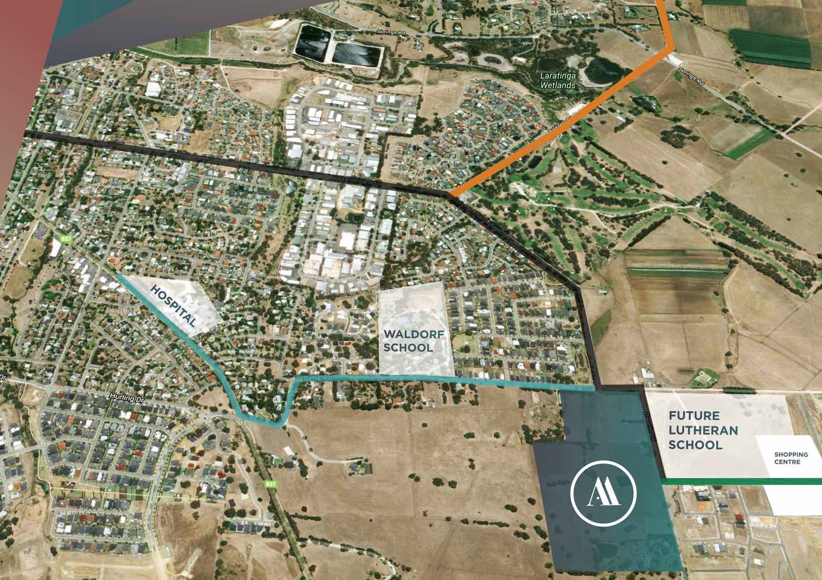
- Mount Barker Waldorf School - 710m west
- Mount Barker South Primary School - 2.3km west
- St Mark's Lutheran School - 2.5km north-west
- St Francis de Sales College - 2.6km north-west
- Mount Barker High School - 2.7km north-west
- Mount Barker Primary School - 3.4km north-west
Popular Estates near Adore Estate - Mount Barker
Latest New Home Articles for You

18/Mar/2026 | OpenLot.com.au
Queensland: Top 30 Most Searched Housing Developments (February 2026)
If you’ve been exploring housing opportunities across Queensland, Februar...

16/Mar/2026 | OpenLot.com.au
New South Wales: Top 30 Most Searched Housing Developments (February 2026)
If you’ve been considering a move in New South Wales, February 2026 provi...

09/Mar/2026 | OpenLot.com.au
Victoria: Top 30 Most Searched Housing Developments (February 2026)
If you’ve been exploring housing opportunities in Victoria, February 2026...

20/Feb/2026 | OpenLot.com.au
Display Homes at Drouin Fields Estate: A Thriving Community in Drouin
Welcome to Drouin Fields, a place where beauty, space, and modern luxury ...

19/Feb/2026 | OpenLot.com.au
Display Homes at Manor Lakes Esate: A Thriving Waterside Community in Manor Lakes
A place where you can settle in, rather than just settle down. Named for ...

13/Feb/2026 | OpenLot.com.au
🏠 Victoria: Top 30 Most Searched Townhouse Developments – January 2026

11/Feb/2026 | OpenLot.com.au
🏡 Top 30 Most Searched Estates by State - January 2026

10/Feb/2026 | OpenLot.com.au
Victoria: Top 30 Most Searched Housing Developments (January 2026)
If you’ve been considering making a move in Victoria, January 2026 offere...

10/Feb/2026 | OpenLot.com.au
Queensland: Top 30 Most Searched Housing Developments (January 2026)
If you’ve been considering making a move in Queensland, January 2026 offe...