

Ashworth Drive, Traralgon VIC 3844
This information is estimated by the OpenLot research team. Let us know here to provide up-to-date information about this development.
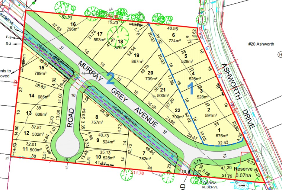
| Total new homes | 22 |
| Area size | 2.12 hectares |
| Growth Region | Gippsland Regional Growth Areas |
| City council | Latrobe City Council |
| Developer | 1313 Property |
Land for Sale, House and Land Packages:
Popular Estates near Ashworth Drive, Traralgon


 4
4
 2
2
 2
2


Updates for Ashworth Drive, Traralgon
Location & Map for Ashworth Drive, Traralgon
Visit Display Homes near Ashworth Drive, Traralgon

Land Price Trend in Traralgon VIC 3844
- In Oct - Dec 24, the median price for vacant land in Traralgon VIC 3844 was $294,000. *
- From Oct - Dec 17 to Oct - Dec 24, the median price for vacant land in Traralgon VIC 3844 has increased 100%. *
- From 2008 to 2024, the median price for vacant land in Traralgon VIC 3844 has increased 178.1%. *
Vacancy Rate in Traralgon VIC 3844
View full vacancy rate history in Traralgon VIC 3844 via SQM Research.
Schools near Ashworth Drive, Traralgon
Here are 6 schools near Ashworth Drive, Traralgon:
Prep-6 Catholic Primary School
7-12 Government Secondary School - School Head Campus
Prep-6 Government Primary School
Prep-6 Government Primary School
7-12 Catholic Secondary School - School Head Campus
Prep-6 Catholic Primary School
Reviews & Comments on Ashworth Drive, Traralgon
Estate Brochure, Masterplan, Engineering Plan, Plan of Subdivision (POS), Design Guidelines
FAQs about Ashworth Drive, Traralgon
View all estates from 1313 Property
- St Gabriel's School - 806m south
- Traralgon College - 1.5km south-east
- Traralgon (Stockdale Road) Primary School - 1.7km south-east
- Traralgon (Kosciuszko Street) Primary School - 2.2km south
- Lavalla Catholic College - 2.3km south
- St Michael's School - 2.8km south-east
Popular Estates near Ashworth Drive, Traralgon
Latest New Home Articles for You

09/Mar/2026 | OpenLot.com.au
Victoria: Top 30 Most Searched Housing Developments (February 2026)
If you’ve been exploring housing opportunities in Victoria, February 2026...

20/Feb/2026 | OpenLot.com.au
Display Homes at Drouin Fields Estate: A Thriving Community in Drouin
Welcome to Drouin Fields, a place where beauty, space, and modern luxury ...

19/Feb/2026 | OpenLot.com.au
Display Homes at Manor Lakes Esate: A Thriving Waterside Community in Manor Lakes
A place where you can settle in, rather than just settle down. Named for ...

13/Feb/2026 | OpenLot.com.au
🏠 Victoria: Top 30 Most Searched Townhouse Developments – January 2026

11/Feb/2026 | OpenLot.com.au
🏡 Top 30 Most Searched Estates by State - January 2026

10/Feb/2026 | OpenLot.com.au
Victoria: Top 30 Most Searched Housing Developments (January 2026)
If you’ve been considering making a move in Victoria, January 2026 offere...

10/Feb/2026 | OpenLot.com.au
Queensland: Top 30 Most Searched Housing Developments (January 2026)
If you’ve been considering making a move in Queensland, January 2026 offe...

09/Feb/2026 | OpenLot.com.au
Western Australia: Top 30 Most Searched Housing Developments (January 2026)
If you’ve been considering making a move in Western Australia, January 20...

06/Feb/2026 | OpenLot.com.au
South Australia: Top 30 Most Searched Housing Developments (January 2026)
If you’ve been considering making a move in South Australia, January 2026...