
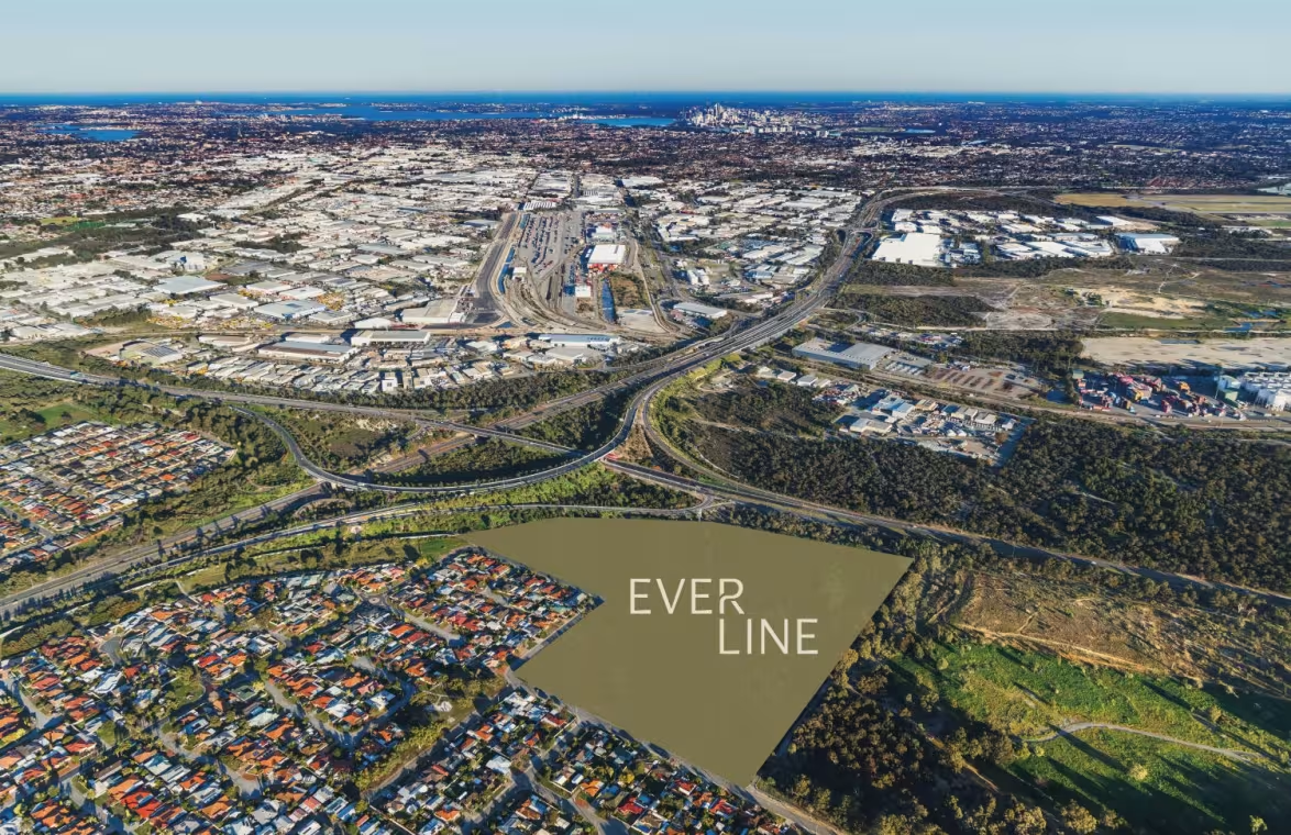
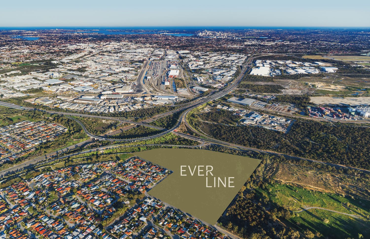
Everline Estate - Forrestfield
[NEW RELEASE] A New Way Home in Forrestfield


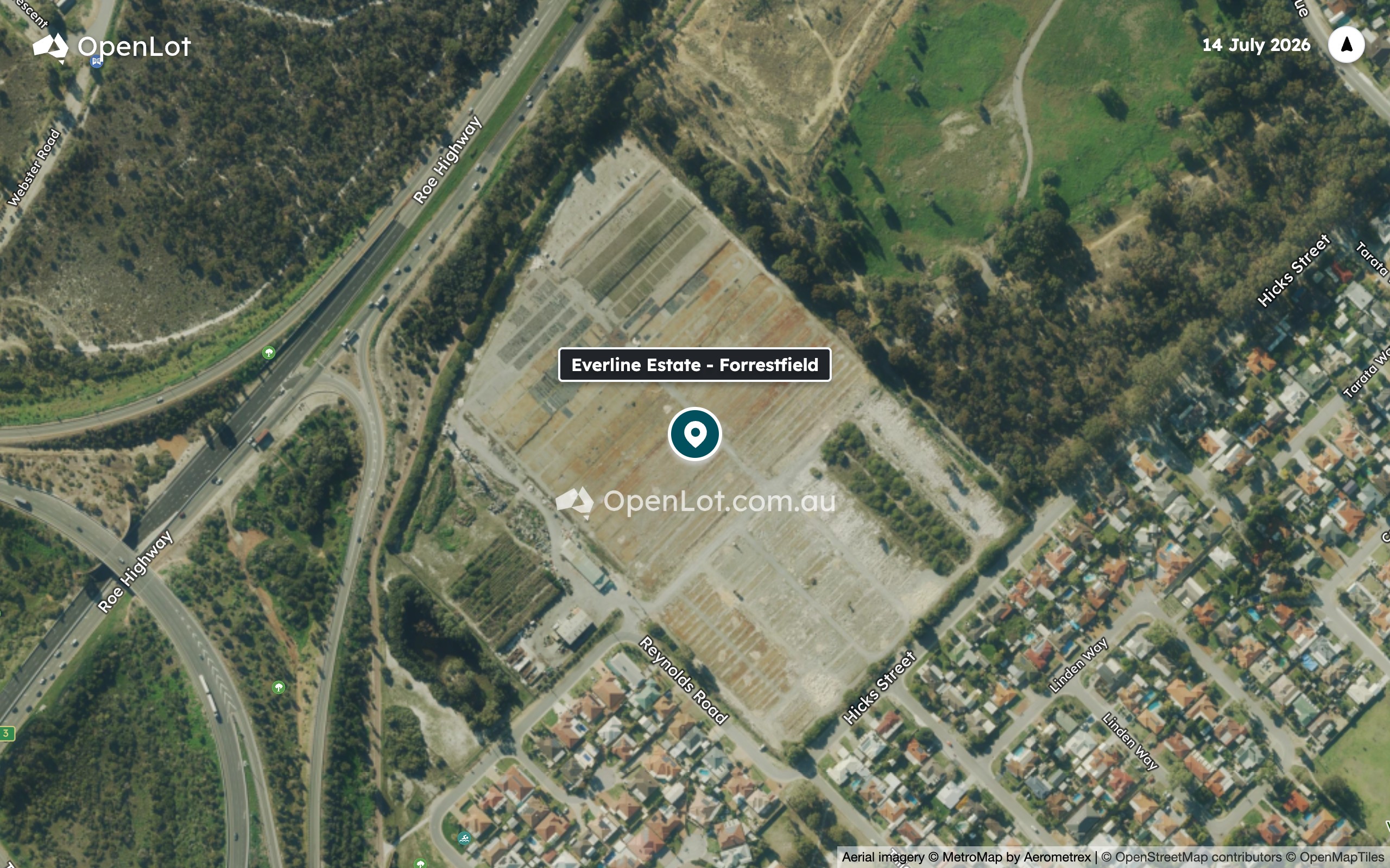
- Employment & City Access
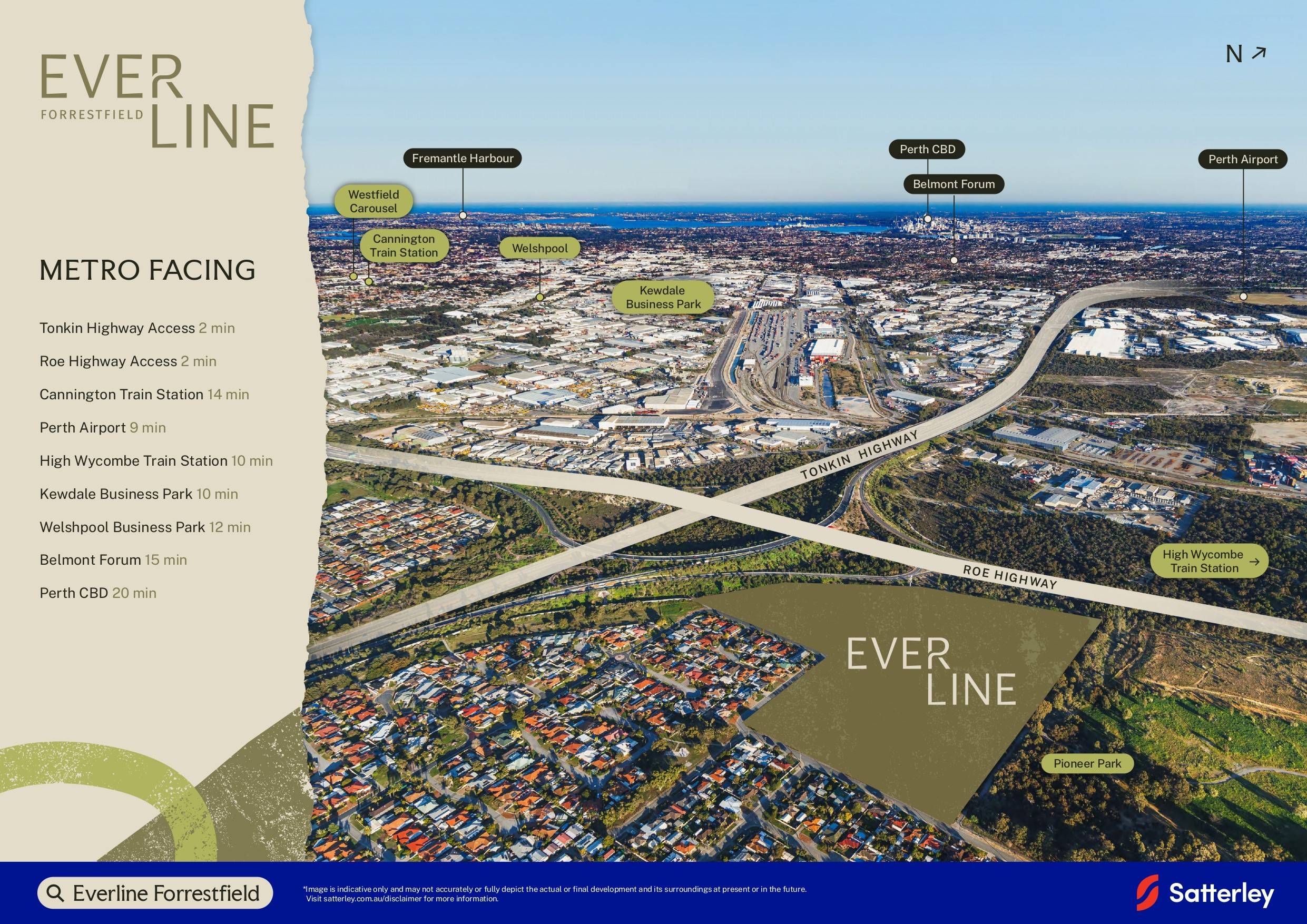
• Everline sits in close proximity to major employment areas including Kewdale, Welshpool, Belmont, High Wycombe and Forrestfield
• Perth Airport is about 9 minutes from home - perfect for airport-based workers and regular travellers - • Perth CBD is around 20 minutes by car (depending on traffic) Transport
• Roe and Tonkin Highways are just 2 minutes from home, providing direct connections across Perth’s eastern and south-eastern corridors
• High Wycombe Station is around 10 minutes by car or 17 minutes by bike, connecting to Perth’s Airport Line
• Kenwick and Beckenham trains stations are also within 15 minutes by car and around 25 minutes by bike
• Local bus services connect Forrestfield with High Wycombe Station, Belmont, Perth and Westfield Carousel - Shopping & Everyday Amenity
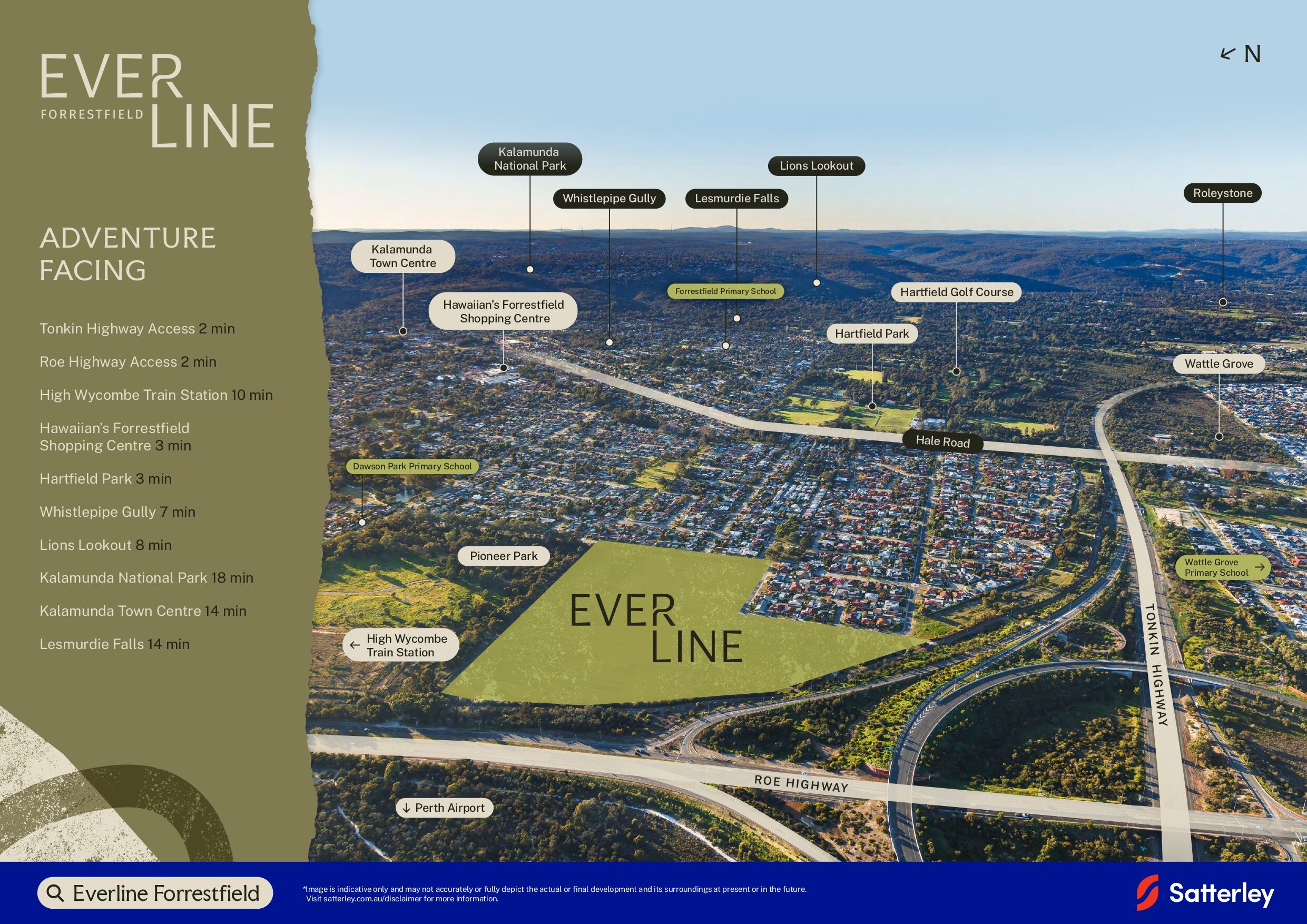
• Hawaiian’s Forrestfield provides convenient everyday shopping, with supermarkets, food and services all in one local centre
• Wattle Grove Shopping Centre adds further everyday retail, health and service options nearby
• For a broader retail, dining and entertainment mix, Westfield Carousel and Belmont Forum are - • Whistlepipe Gully offers one of the closest ways to get out on the trail, with the walk beginning in Forrestfield
• Head into the Perth Hills for Kalamunda National Park, Lesmurdie Falls and Mundy Regional Park
• Jorgensen Park Walk and Lions Lookout Walk offer more ways to explore on foot, while the Zig Zag Scenic Drive can be enjoyed on two wheels
• Closer to home, Hartfield Country Club offers an 18-hole golf course in Forrestfield - Eat & Explore
• Start the weekend with coffee or brunch at Mason & Bird in Kalamunda, or keep it local at Gracie’s Cafe in Forrestfield
• Settle in for a long lunch or lazy afternoon at Masonmill, with gardens, drinks, dining and mini golf all in one place, or meet friends for a pub meal or catch the game at Kalamunda Hotel
• For dinner, stay close to home with pizza and pasta at Taste of Italy in Hawaiian’s Forrestfield, or head into Kalamunda for an evening at The Vault Restaurant
• Kalamunda’s regular farmers, artisan and seasonal night markets add another reason to head up the hill
What's special about Everline Estate - Forrestfield This snippet was generated with OpenLotAI based on the information available in this listing. It was not provided by the developer and we encourage you to contact the agent directly to request more details.
- Several primary and secondary schools are nearby, including Forrestfield Primary School, Wattle Grove Primary School and Darling Range Sports College.
- Tillia Court Reserve is close by at 350m, with Pioneer Park 500m away and Virgillia Way Reserve 600m away.
- Bus stops on Cypress Road are nearby at 250m, with another stop on Hicks Street 400m away.
- Woolworths is 1.6 km away, while Aldi and Coles are both 1.8 km away for grocery shopping.
- Priceline Pharmacy, Forrestfield Pharmacy, Chatime and Dôme are all 1.7 km away for everyday services and refreshments.
What's within 5 km of Everline Estate - Forrestfield
-
-
 Distance
- 1.1km
-
 Approximate drive time
- 2min
-
 Approximate walk time
- 18min
-
-
-
Distance
- 1.2km
-
Approximate drive time
- 3min
-
Approximate walk time
- 20min
-
-
-
Distance
- 1.5km
-
Approximate drive time
- 3min
-
Approximate walk time
- 24min
-
-
-
Distance
- 1.8km
-
Approximate drive time
- 4min
-
Approximate walk time
- 29min
-
-
-
Distance
- 2.0km
-
Approximate drive time
- 5min
-
Approximate walk time
- 33min
-
-
-
Distance
- 250m
-
Approximate drive time
- 1min
-
Approximate walk time
- 4min
-
-
-
Distance
- 250m
-
Approximate drive time
- 1min
-
Approximate walk time
- 4min
-
-
-
Distance
- 400m
-
Approximate drive time
- 1min
-
Approximate walk time
- 6min
-
-
-
Distance
- 550m
-
Approximate drive time
- 1min
-
Approximate walk time
- 9min
-
-
-
Distance
- 3.4km
-
Approximate drive time
- 8min
-
Approximate walk time
- 55min
-
-
-
Distance
- 1.1km
-
Approximate drive time
- 2min
-
Approximate walk time
- 17min
-
-
-
Distance
- 1.6km
-
Approximate drive time
- 4min
-
Approximate walk time
- 26min
-
-
-
Distance
- 1.7km
-
Approximate drive time
- 4min
-
Approximate walk time
- 28min
-
-
-
Distance
- 1.8km
-
Approximate drive time
- 4min
-
Approximate walk time
- 29min
-
-
-
Distance
- 1.8km
-
Approximate drive time
- 4min
-
Approximate walk time
- 29min
-
-
-
Distance
- 350m
-
Approximate drive time
- 1min
-
Approximate walk time
- 6min
-
-
-
Distance
- 500m
-
Approximate drive time
- 1min
-
Approximate walk time
- 8min
-
-
-
Distance
- 600m
-
Approximate drive time
- 1min
-
Approximate walk time
- 10min
-
-
-
Distance
- 750m
-
Approximate drive time
- 2min
-
Approximate walk time
- 12min
-
-
-
Distance
- 850m
-
Approximate drive time
- 2min
-
Approximate walk time
- 14min
-
-
-
Distance
- 1.7km
-
Approximate drive time
- 4min
-
Approximate walk time
- 27min
-
-
-
Distance
- 1.7km
-
Approximate drive time
- 4min
-
Approximate walk time
- 28min
-
-
-
Distance
- 2.2km
-
Approximate drive time
- 5min
-
Approximate walk time
- 36min
-
-
-
Distance
- 4.0km
-
Approximate drive time
- 9min
-
Approximate walk time
- 1h 5min
-
-
-
Distance
- 4.9km
-
Approximate drive time
- 11min
-
Approximate walk time
- 1h 20min
-
-
-
Distance
- 1.6km
-
Approximate drive time
- 4min
-
Approximate walk time
- 27min
-
-
-
Distance
- 1.7km
-
Approximate drive time
- 4min
-
Approximate walk time
- 27min
-
-
-
Distance
- 1.7km
-
Approximate drive time
- 4min
-
Approximate walk time
- 27min
-
-
-
Distance
- 1.7km
-
Approximate drive time
- 4min
-
Approximate walk time
- 28min
-
-
-
Distance
- 1.7km
-
Approximate drive time
- 4min
-
Approximate walk time
- 28min
-
-
-
Distance
- 1.7km
-
Approximate drive time
- 4min
-
Approximate walk time
- 28min
-
-
-
Distance
- 1.7km
-
Approximate drive time
- 4min
-
Approximate walk time
- 28min
-
-
-
Distance
- 4.9km
-
Approximate drive time
- 11min
-
Approximate walk time
- 1h 19min
-
-
-
Distance
- 5.0km
-
Approximate drive time
- 11min
-
Approximate walk time
- 1h 21min
-
Straight-line distance. Drive and walk times are estimates.
Property types for sale
Location & Masterplan for Everline Estate - Forrestfield
Popular Estates near Everline Estate - Forrestfield


 298m²
- 881m²
 3
 2
 2


Construction updates for Everline Estate
Development overview of Everline Estate - Forrestfield
This information is estimated by the OpenLot research team. Let us know here to provide up-to-date information about this development.
Project team of Everline Estate - Forrestfield

Updates for Everline Estate - Forrestfield

Visit Display Homes near Everline Estate - Forrestfield


Schools near Everline Estate - Forrestfield
Land Price Trend in Forrestfield WA 6058
Below shows the price trend from vacant land sales recorded in Forrestfield WA 6058.
The data and information provided by Terralytics (Aust) Pty Ltd (Terralytics Data) is general in nature and is not intended to constitute professional advice. Read more
It should not be relied upon as a substitute for legal, financial, valuation, or other specialist advice relevant to your specific circumstances.
Terralytics uses commercially reasonable endeavours to ensure the Terralytics Data is current and accurate. However, as the Terralytics Data incorporates information sourced from third parties, Terralytics makes no representation or warranty — express or implied — as to its accuracy, completeness, or currency. To the maximum extent permitted by applicable law, Terralytics excludes all liability for any loss or damage (including consequential loss) arising out of or in connection with reliance on the Terralytics Data, whether arising in contract, tort (including negligence), statute, or otherwise.
Popular Estates near Everline Estate - Forrestfield
Not exactly what you're looking for? Try surrounding suburbs

East Cannington WA 6107
1 estate | City of Canning
5.5km south-west
Bushmead WA 6055
1 estate | City of Swan
6.6km north
Maida Vale WA 6057
2 estates | City of Kalamunda
3.3km north
Wattle Grove WA 6107
5 estates | City of Kalamunda
2.8km south
Kenwick WA 6107
2 estates | City of Gosnells
5.7km south-west
High Wycombe WA 6057
2 estates | City of Kalamunda
4.4km north
Latest published articles



FAQs about Everline Estate - Forrestfield
Satterley Property Group is the developer behind Everline Estate - Forrestfield.
Everline Estate - Forrestfield consists of 250 homes.
Everline Estate - Forrestfield falls under City of Kalamunda.
Everline Estate - Forrestfield is 14 km east of Perth CBD.
Nearby schools for Everline Estate - Forrestfield:
- Dawson Park Primary School - 1.1km north-east
- Woodlupine Primary School - 1.2km east
- Wattle Grove Primary School - 1.5km south-west
- Forrestfield Primary School - 1.8km east
- Darling Range Sports College - 2.0km north-east
- HillSide Christian College - 2.7km east