

Whitlam Estate - Whitlam
This information is estimated by the OpenLot research team. Let us know here to provide up-to-date information about this development.
| Total new homes | 2,100 |
| Area size | N/A |
| Growth Region | Canberra Growth Regions |
| City council | Australian Capital Territory |
| Developer | ACT Government Suburban Land Agency |
| Distance to | Canberra CBD - 9 km north-west Canberra Airport - 14 km west |
Land for Sale, House and Land Packages:
13 Display Homes in Whitlam Estate Display Village - Whitlam

 4
4
 2
2
 2
4
2
2
4
2.5
2
4
2.5
2
4
2
2
4
2
2
2
4
2
2
4
2.5
2
4
2.5
2
4
2
2
4
2
2
Popular Estates near Whitlam Estate - Whitlam


Updates for Whitlam Estate - Whitlam
Facebook updates:
Related news:
Future residents of Canberra's newest suburb named after a former prime minister have kickstarted their connections with each other.

The views from Whitlam are stunning, with vistas of the Brindabella Ranges and Black Mountain on offer. An emphasis on green spaces and waterways will also make Whitlam an enviable address. T

Missing articles? Send us a link here.
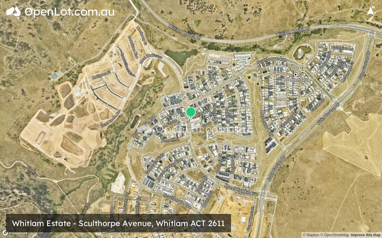
Location & Map for Whitlam Estate - Whitlam
Vacancy Rate in Whitlam ACT 2611
View full vacancy rate history in Whitlam ACT 2611 via SQM Research.
Schools near Whitlam Estate - Whitlam
Here are 6 schools near Whitlam Estate - Whitlam:
K-6 Government Primary School
K-6 Government Primary School
7-10 Government Secondary School
11-12 Government Secondary School
K-6 Government Primary School
K-10 Government Combined School
Suburb Planning Review in Whitlam ACT 2611
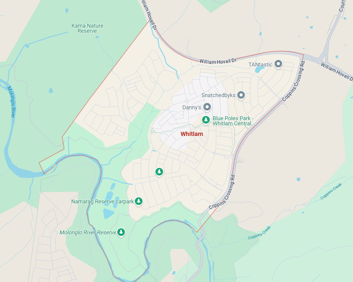
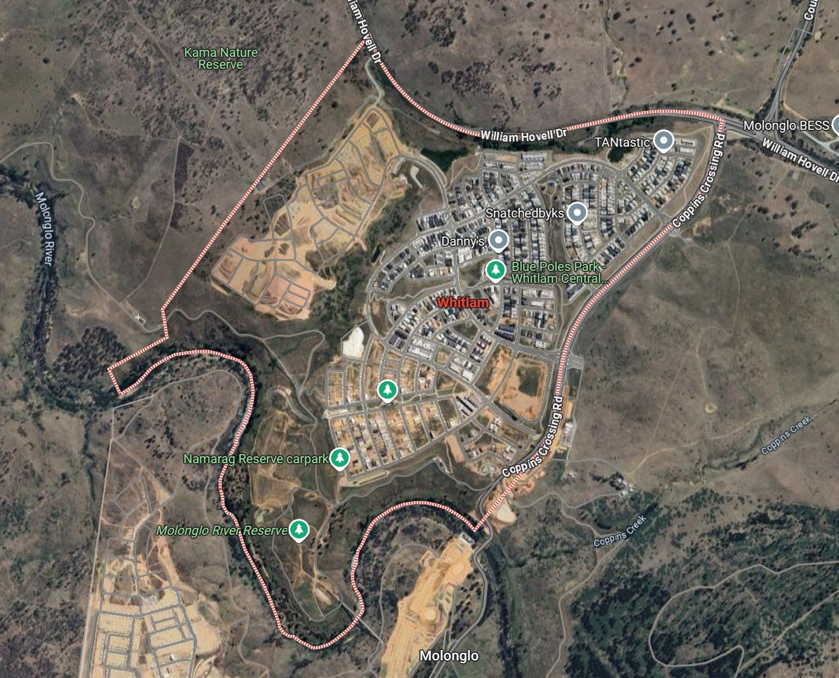
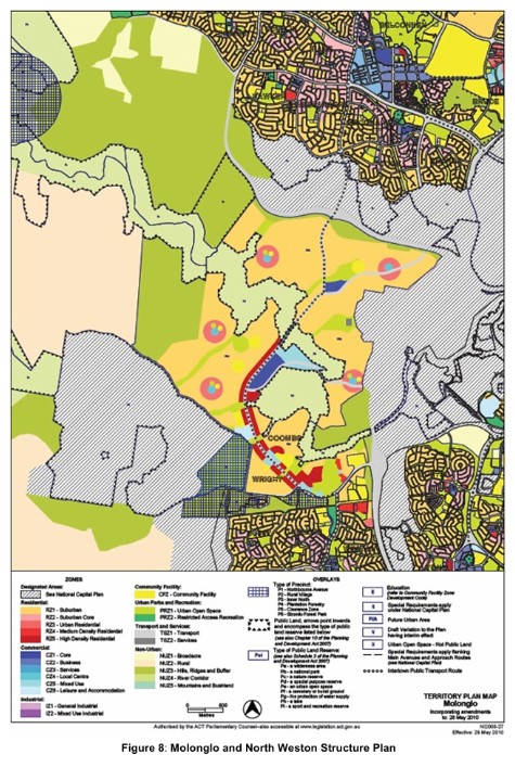
Whitlam is a suburb of approximately 450 hectares within the Australian Capital Territory (ACT), forming part of the Molonglo Valley district of Canberra, located 10 km South of Queanbeyan, 10 km West of Canberra.
Named after former Prime Minister Gough Whitlam, the suburb was officially gazetted in 2016. It forms part of the ACT's broader plan for sustainable urban growth within the Molonglo Valley corridor. The area previously consisted of open rural land and has been transformed into a modern residential community.
The suburb boundary is located along William Hovell Drive to the north and Coppins Crossing Road to the east. Property boundaries and Kama Natural Reserve form the western boundary. Molonglo River forms the entire boundary to the south.
The Coppins Crossing Road provides access to the entire suburb, providing the north-south connection along the eastern boundary. Sculthorpe Avenue, Maymuru Way and Hazel Hawke Avenue provide east and west connections from Coppings Crossing Road to provide local road networks throughout Whitlam.
The northern portion of the suburb is urban mixed density residential area with parks and a café. The southern and western portions of the suburb are under new residential development, using the remaining vacant land to providing housing, recreation space and river access. Land along the Molonglo Rover has been dedicated to green space, bushland, and environmental reserves.
Whitlam's National Environmental Significance (NES Plan)
In accordance with the Environment Protection and Biodiversity Conservation Act 1999 (EPBC Act), the ACT Government's Molonglo Valley Plan for the Protection of Matters of National Environmental Significance (NES Plan) was approved by the Commonwealth Government as a strategic assessment under Part 10 of the Act.
The NES Plan (Matters of National Environmental Significance Plan) was developed to assess the environmental impacts of urban development proposed under Territory Plan Variation No. 281 and National Capital Plan Amendment No. 63 in the Molonglo Valley.
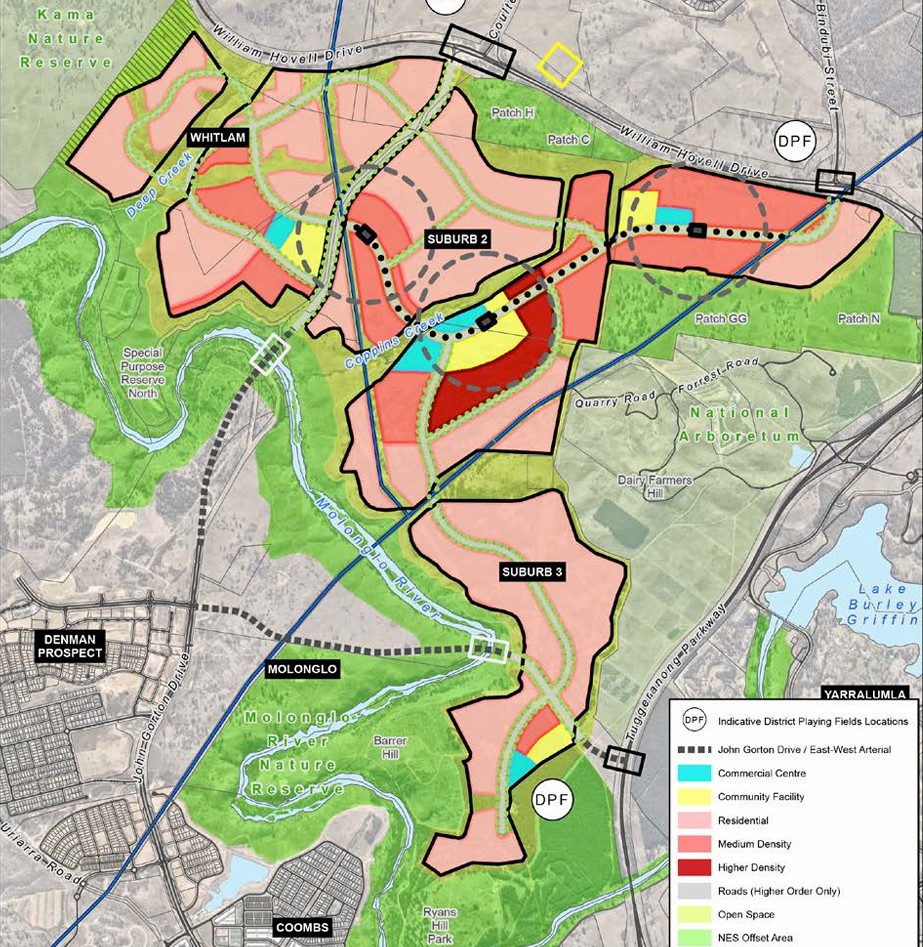
A NES Plan commitment required that a planning and design framework be prepared to guide detailed planning and future development within Molonglo Stage 3, which is located between the Molonglo River and William Hovell Drive and comprises the suburb of Whitlam and two unnamed suburbs to the east of John Gorton Drive.
Mononglo Valley Plan
The Molonglo Valley Plan for the Protection of Matters of National Environmental Significance (NES Plan) was developed in response to the complexity and environmental sensitivity of proposed urban development in the Molonglo Valley. Recognising the potential scale and impact, the ACT and Commonwealth Governments agreed in 2008 to undertake a strategic assessment under Part 10 of the EPBC Act, rather than assess individual projects in isolation.
This agreement was later amended in 2010 to specifically incorporate the NES Plan, which addresses urban development, infrastructure, and broadacre land use in East and West Molonglo and North Weston. The plan is closely tied to the Molonglo and North Weston Structure Plan, a statutory planning instrument within the ACT Territory Plan, which defines the development framework for the region.
The NES Plan reflects both the proposed development activities and the ACT Government’s commitments to protect Matters of National Environmental Significance (MNES). These include ecological features such as natural corridors, significant trees, habitats, and recreational links, with an emphasis on maintaining Canberra’s unique balance between urban form and natural landscape. Key urban planning principles outlined in the Structure Plan promote walkable neighbourhoods, integrated centres, and sensitivity to the valley's topography and character. The Structure Plan will guide development over the next 30 years and will be adapted as needed to uphold conservation priorities and respond to evolving planning requirements.
Whitlam's Molonglo Valley Planning Framework
Whitlam is part of the Molonglo Valley Stage 3 Urban Development Strategy, which guides land use, infrastructure provision, and environmental management in this growth corridor, approved on 20 December 2011, by the Commonwealth Minister for the Environment.
Residential Development
Molonglo Stage 3 is projected to accommodate 10,000 to 12,000 dwellings, comprising a mix of low, medium, and high-density housing, including mixed-use residential areas. Residential locations will align with the framework plan.
A key planning principle is that higher-density development must be located near commercial centres. New schhool and within 800 metres of rapid transport services. Final dwelling numbers and densities will be confirmed during subdivision planning.
Commercial Centres
The development will include the following commercial centres, as indicated in the framework plan:
A local-scale centre in Whitlam, anchored by a small supermarket.
A group-scale centre in Suburb 2, on the inter-town public transport (IPT) route, anchored by a full-line supermarket (with potential for a second, subject to retail needs assessment).
A second local-scale centre in northeast Suburb 2, near the IPT route.
A local-scale centre in Suburb 3, also anchored by a small supermarket.
Whitlam's Molonglo 3 East (M3E) Strategic Design Project
Molonglo 3 East (M3E) is a major urban development initiative within Canberra’s Molonglo Valley, marking the third stage of the district’s expansion and encompassing three future suburbs. It has been recognised by the Planning Institute of Australia (PIA) with a commendation in the Strategic Planning category, highlighting it as a benchmark in strategic infrastructure design and integrated water quality management.
The project is designed to accommodate approximately 30,000 future residents as part of a broader goal to grow the Molonglo Valley to over 70,000 people by 2050. It was led by SMEC’s Urban Communities Team in collaboration with the ACT Environment, Planning and Sustainable Development Directorate (EPSDD) and Icon Water. The design places a strong emphasis on:
Blue-green infrastructure for managing heat and enhancing livability,
Water Sensitive Urban Design (WSUD) integrated throughout the landscape,
Strategic alignment of roads, public transport, schools, and local centres,
A Cost Effectiveness Analysis comparing distributed WSUD treatments with traditional large pond systems.
The project stands out for its collaborative approach, involving intensive stakeholder engagement to optimise infrastructure, reduce long-term costs, and ensure future community needs are met. The PIA judges commended it as an example of climate-adaptive, integrated urban design that provides a foundation for resilient, connected neighbourhoods and demonstrates how strategic planning can define the structure and relationship of future urban areas to natural assets like the Molonglo River.
Molonglo Valley Stage 3 Urban Development
The Molonglo Valley Stage 3 Urban Development was lodged on 29 June 2017, in order to secure Environmental Impact Statement exemption. On 8 May 2018, Mick Gentleman, Minister for Planning and Land Management signed off on the EIS exemption, allowing development applications to be lodged regarding the Stage 3 component, providing statutory public notification, ensuring transparency and public input.
Whitlam's Molonglo Valley District Strategy
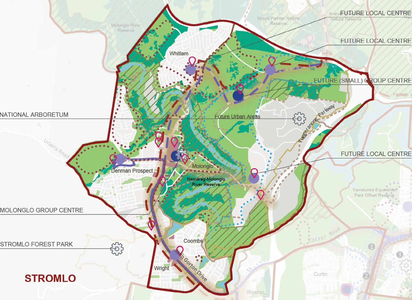
The Molonglo Valley District Strategy Plan outlines key structural elements and strategic directions for the district, aligned with five major planning drivers (detailed in Volume 1). It serves as a high-level guide to shaping future growth, infrastructure, and community development in the area.
Key Elements Highlighted in the Plan:
Blue-green infrastructure: Existing and potential future ecological and water networks.
Transport connections: Current and proposed new corridors, with some areas flagged for further investigation.
Economic focus areas: Locations identified for enhanced economic development and employment opportunities.
Community centres: Existing and future group/local centres identified for further planning and investment to ensure their viability as community hubs.
Recreational and community facilities: Proposed new sites to serve the growing population.
Future development precincts: Areas earmarked for housing and urban expansion, based on estate plans, land release schedules, or current development proposals—each with estimated dwelling yields.
This plan provides the spatial and strategic framework for coordinated, sustainable urban growth across the Molonglo Valley district.
Whitlam Suburb Development
Whitlam is a master-planned suburb located in the Molonglo Valley district of Canberra, ACT. Developed by the Suburban Land Agency (SLA), it forms part of Canberra’s westward urban expansion and is designed to support diverse, sustainable, and connected communities. When complete, Whitlam is expected to house thousands of residents across a mix of housing types and community facilities, integrated with open space, active transport networks, and essential infrastructure.
Overall Vision for Whitlam
Approximately 3,000+ dwellings across multiple stages
Focus on housing diversity, affordability, and sustainability
Integrated urban design with green corridors, stormwater management, and active travel paths
Proximity to the future Molonglo Town Centre
Infrastructure built to Bushfire Attack Level (BAL) 12.5
Streetscapes defined by deciduous trees, promoting seasonal comfort and reduced urban heat
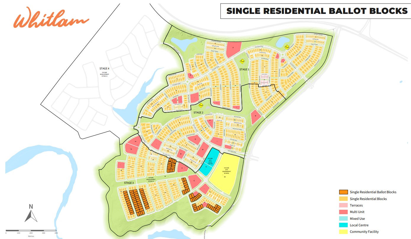
Whitlam Development Stages
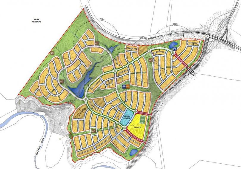
Stage 1:
542 single residential blocks
9 multi-unit sites with up to 77 dwellings
Block sizes range from 150 m² to 1,027 m²
2 stormwater ponds, parklands, shared paths, BBQ areas, and children’s playgrounds
Local Neighbourhood Park with shade structures and fixed play equipment
Four entry points from John Gorton Drive
Artistic landmark installation and formal boulevard entry
10% of site required clearance of unexploded ordnance from former military training use
Stage 2:
Focused on expanding the residential footprint
Additional blocks offered with a continued emphasis on lot diversity
Introduction of local infrastructure to support growing population
Early planning and works for future school sites and retail centres
Stage 3 and Beyond:
Integration of future community and commercial centres
Planned provision of a government primary school
Development of multi-use open spaces, including sports facilities
Road and transport links expanded toward the Molonglo River
Future links to Denman Prospect and the Molonglo Town Centre
Additional higher-density sites expected closer to public transport corridors
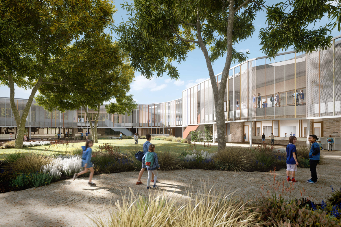
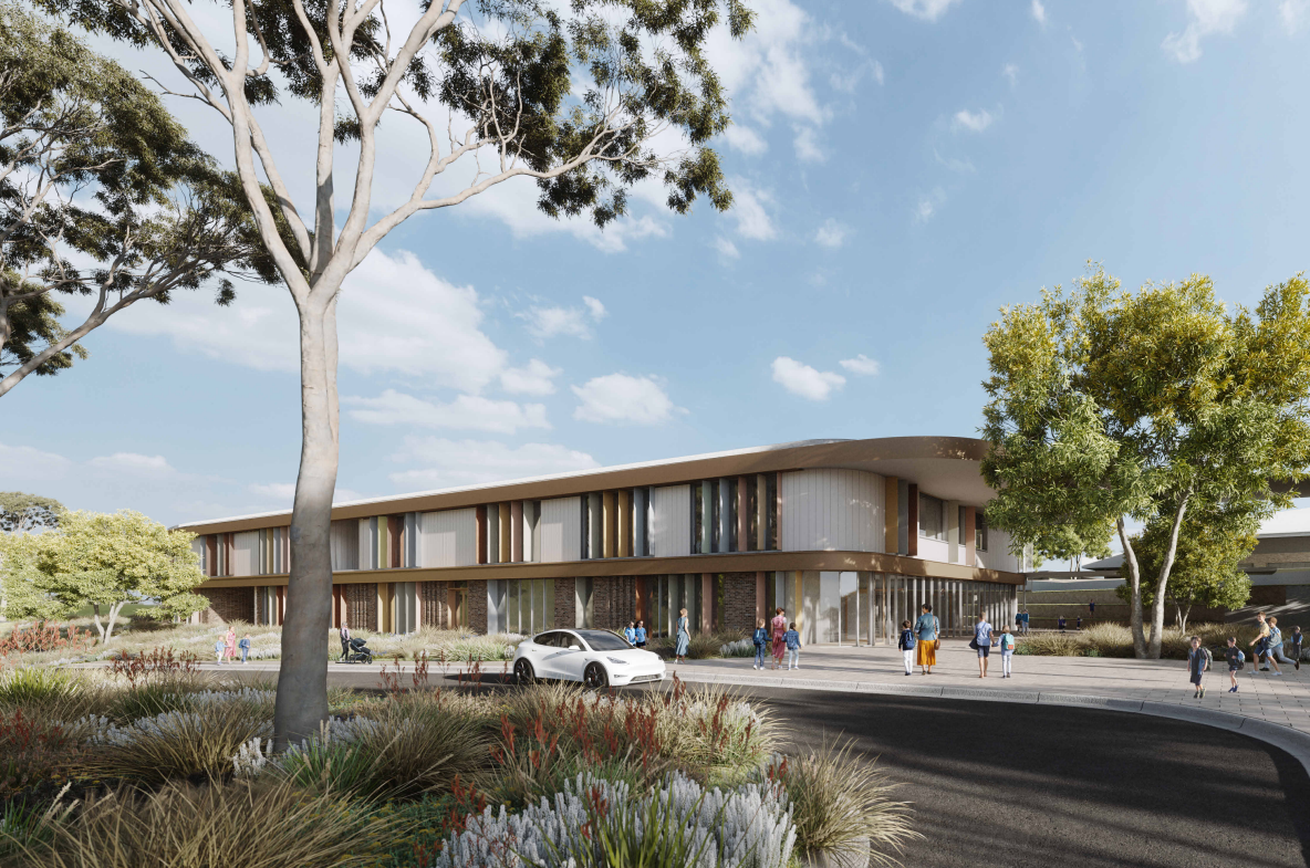
Whitlam's New Primary School
The ACT Government has submitted a development application for a new Preschool to Year 6 public school and Early Childhood Education and Care Centre (ECEC) in Whitlam, with a total investment of $76.8 million. The facility, expected to open in 2026, will cater for up to 780 students and 130 ECEC places, and will be built on a 5-hectare site at the corner of John Gorton Drive, Hazel Hawke Avenue, and Alice Moyle Way.
The design features a J-shaped main building with classrooms, administration offices, library, and ECEC, along with a separate gymnasium, hardcourts, sports field, and 135+ car parking spaces, including EV charging stations. The school will be sustainably built, with on-site solar power, shaded outdoor areas, and significant green landscaping. It will be integrated into the local transport network with bike paths, footpaths, and public transport stops. Traffic studies show the project will have minimal impact on the local road network.
Whitlam Suburb Summary
References
City Renewal Authority – Planning and Urban Renewal (Whitlam & Molonglo)
ACT Environment, Planning and Sustainable Development Directorate (EPSDD)
- Main page: https://www.planning.act.gov.au
- Whitlam-specific development info (Molonglo Valley): https://www.planning.act.gov.au/planning-our-city/planning-projects/molonglo-valley/whitlam
ACT Government – Suburban Land Agency (Whitlam Land Sales & Planning)
ACT Territory Plan (similar to LEP)
ACT Planning System Review and Reform
ACT ePlan – Interactive Territory Plan Viewer (like NSW ePlanning Spatial Viewer)
Molonglo Valley Development Guidelines (includes Whitlam)
hitlam Neighbourhood Design Brief – Suburban Land Agency
Reviews & Comments on Whitlam Estate - Whitlam
Estate Brochure, Masterplan, Engineering Plan, Plan of Subdivision (POS), Design Guidelines
FAQs about Whitlam Estate - Whitlam
View all estates from ACT Government Suburban Land Agency
- Weetangera Primary School - 2.6km north
- Hawker Primary School - 2.7km north
- Belconnen High School - 3.1km north
- Hawker College - 3.2km north
- Macquarie Primary School - 3.3km north-east
- Evelyn Scott School - 3.7km south
Popular Estates near Whitlam Estate - Whitlam
Latest New Home Articles for You

09/Mar/2026 | OpenLot.com.au
Victoria: Top 30 Most Searched Housing Developments (February 2026)
If you’ve been exploring housing opportunities in Victoria, February 2026...

20/Feb/2026 | OpenLot.com.au
Display Homes at Drouin Fields Estate: A Thriving Community in Drouin
Welcome to Drouin Fields, a place where beauty, space, and modern luxury ...

19/Feb/2026 | OpenLot.com.au
Display Homes at Manor Lakes Esate: A Thriving Waterside Community in Manor Lakes
A place where you can settle in, rather than just settle down. Named for ...

13/Feb/2026 | OpenLot.com.au
🏠 Victoria: Top 30 Most Searched Townhouse Developments – January 2026

11/Feb/2026 | OpenLot.com.au
🏡 Top 30 Most Searched Estates by State - January 2026

10/Feb/2026 | OpenLot.com.au
Victoria: Top 30 Most Searched Housing Developments (January 2026)
If you’ve been considering making a move in Victoria, January 2026 offere...

10/Feb/2026 | OpenLot.com.au
Queensland: Top 30 Most Searched Housing Developments (January 2026)
If you’ve been considering making a move in Queensland, January 2026 offe...

09/Feb/2026 | OpenLot.com.au
Western Australia: Top 30 Most Searched Housing Developments (January 2026)
If you’ve been considering making a move in Western Australia, January 20...

06/Feb/2026 | OpenLot.com.au
South Australia: Top 30 Most Searched Housing Developments (January 2026)
If you’ve been considering making a move in South Australia, January 2026...