


Greenbank is approximately 10,605ha within the city of Logan, located 27 kilometres south of Brisbane. The suburb is located in proximity to the Centenary Highway to the west, Mt Lindesay Highway to the east and Logan Motorway to the north. The Spring Mountain Reserve, Oxley Creek and the suburbs of New Beith and North Maclean are found to the south
A rural residential zoned area dominates the southern portion of the suburb, separated from the Greenbank army barracks by the Springfield Greenbank arterial road and Middle Road. The existing Greenbank Army Barracks which occupies 40% of the suburb is located to the north is bounded by Johnson Road and Centenary Highway west and the suburb of Forestdale to the east.

Six pockets of recreational and open space zoned land are found throughout the rural residential land to accommodate parkland, reserves and sporting fields. A large area of Conservation and Environmental Management zoned land (1,485.46 ha) is located in the southwest corner of the suburb and forms part of the Spring Mountain Forest Park, which offers walking trails and vegetated creek networks that flow down through the rural residential properties in proximity.
The large rural residential lots are being developed for smaller lots as the population in South East Queensland expands and the demand for new housing stock rises. Four new developments in Greenbank are, Willowbrook Estate, Covella Estate, Spring Mountain Acreage Estate and the largest being Greenbank Central (Everleigh Estate).
Greenbank Central (Everleigh Estate)
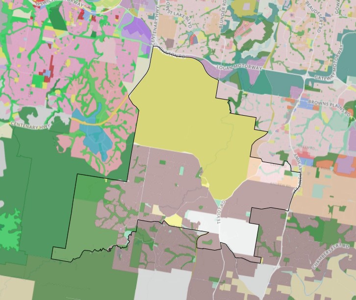
The Queensland State Government introduced the Economic Development Act 2012 which gave the Minister for Economic Development Queensland (MEDQ) the ability to declare Priority Development Areas (PDAs) are parcels of land for development to deliver significant benefits to the community. The southeast portion of Greenbank was identified as Greenbank Central and a Local Development Area in South East Queensland Regional Plan (SEQRP) 2031. The site formed part of the Greater Flagstone Priority Development Area (Greater Flagstone PDA) and was declared on 8 October 2010.
The Greater Flagstone PDA is made up of three (3) areas of Logan that covers 7,188 hectares of land located west of the Jimboomba and Mount Lindsay Highway, along the Brisbane-Sydney rail line. The area is expected to provide up to 50,000 new dwellings and take approximately 30-40 years to redevelop.
Logan City Council’s strategic investigation considered the southeast portion of Greater Flagstone PDA as the land is relatively unconstrained and physically suitable for urban development, with the existing retail and community facilities hub able to support a new urban community.
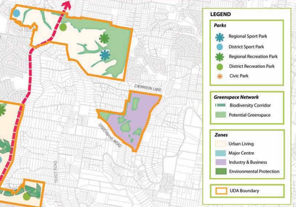
A Development Scheme was prepared to guide the redevelopment under four new zones, Urban Living, Major Centre, Environmental Protection, Industry and Business. The area of the PDA has been called ‘Greenbank Central’ and is envisaged to provide an urban community (2,100 new dwellings and 6,000 people) with a focus on a district centre, neighbourhood centre and primary school. A future train station on the Brisbane - Sydney rail line is envisaged in the long term planning of the area to cater for the new population.

Vision of Greenbank
“The vision for the Greater Flagstone UDA acknowledges the different characters of its three component areas:
Flagstone will be a large integrated urban community of about 100,000 people living in attractive, compact neighbourhoods, and provided with a wide range of facilities and services located in a network of accessible activity centres and low impact business and industry areas. Flagstone will be characterised by an extensive network of environmental and open space corridors that frame neighbourhoods and provide active transport links.
Greenbank Central will be a smaller urban community of around 6,000 people focussed around a district centre (and rail station in the longer term), neighbourhood centre and primary school. Services and facilities in Greenbank Central will serve the local community and a broader catchment of predominantly rural residential development”.
Benefits of Greenbank
The western portion of the Greenbank Central PDA will be partly redeveloped by Mirvac, who control a substantial parcel of land they have named the new community ‘Everleigh’. The new community located opposite the new local shopping centre will provide a series of local parks in proximity to new residential areas and a retail/health centre. The eastern boundary provides for conservation parkland (148 ha) with shared pathways connected to the local area.
A $75 million primary school (prep to year 6) was open at the start of 2022 and the announcement of a $10 million full-sized ALF field and warm-up oval (5.5 ha) will form part of a 25 ha sports, events and recreation precinct located towards the centre of the community.
The surrounding precincts will provide further social, educational, retail and community infrastructure for the new community, such as North Maclean, Bromelton and Park Ridge. Local shopping, services and further employment will be found within the Greenbank Shopping Centre and new local centre.
The Precinct Structure Plan supports the new residential community and facilitates future setbacks for the protection of the environmental area.
Transportation in Greenbank
Everleigh will be connected to public passenger transport, with bus stops provided to facilitate a bus service through the new community. A potential future train station is to be constructed to the north of Greenbank Shopping Centre with a passenger train service that connects Brisbane to Sydney.
The suburb will include a network of shared paths, linking the local parks and conservations parkland to the surrounding and community pathway network.

Greenbank Suburb Summary
References
QLD State Government – Everleigh State School
Mirvac - Everleigh Estate Masterplan
Mirvac - FAQ
DSDILGP – EDQ – Greater Flagstone