


Springfield Lakes is approximately 8.8 square kilometres within the City of Ipswich, forming part of the western urban area of the greater Brisbane metropolitan region within South East Queensland. The suburb is located 34.8 kilometres south west of Brisbane and 20.5 kilometres east of Ipswich. Springfield Lakes enjoys a strategic location with easy access to major urban centres and coastal areas.
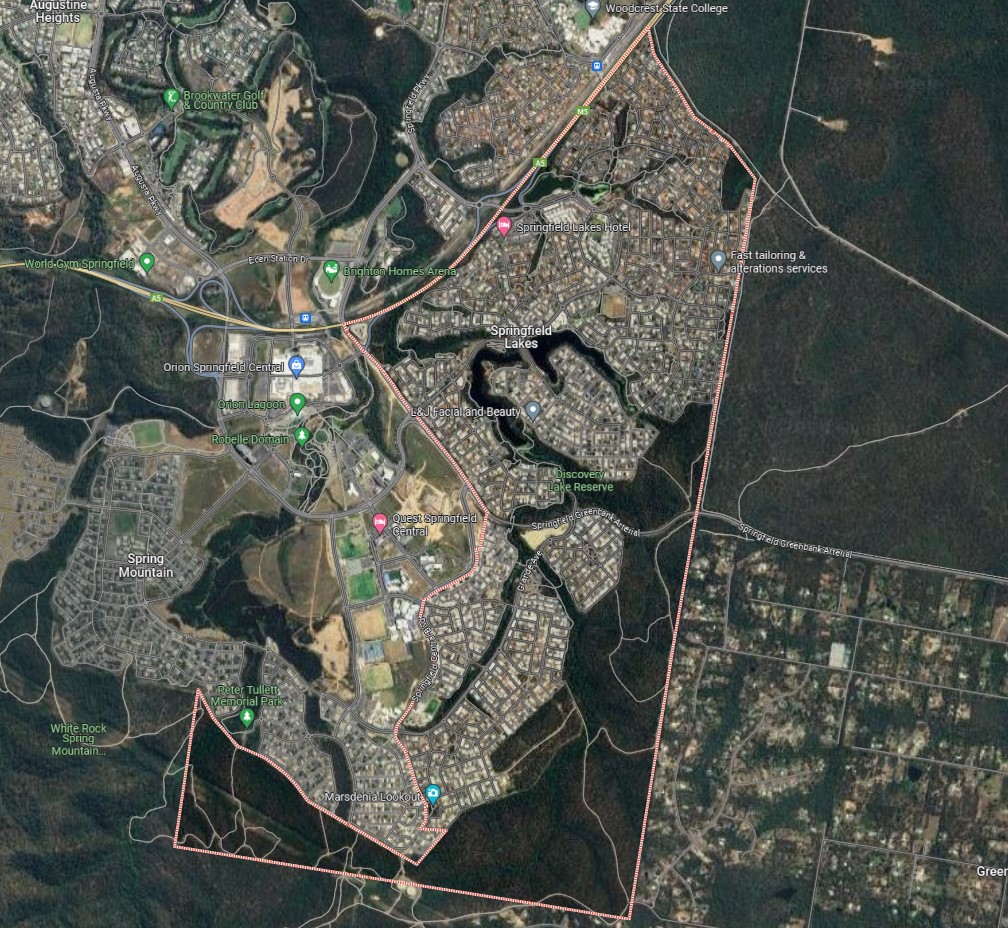
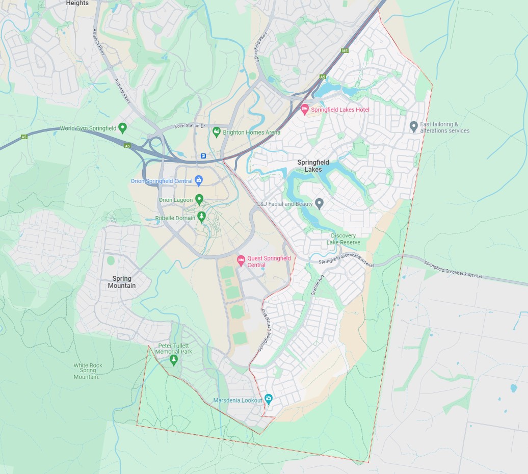
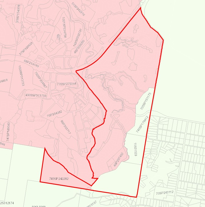
The suburb boundary is located along property boundaries and adjoining White Rock – Spring Mountain forest to the east. The Spring Mountain Forest and property boundaries make up the short southern boundary. The Centenary Highway and adjoining White Rock – Spring Mountain forest provide the northern boundary. Springfield Central Boulevard, Angelica Avenue, Balm Avenue and the Springfield Greenback Arterial make up the western boundary.
Springfield Greenbank Arterial provides local road access (east to west), Springfield Central Boulevard provides local road access (north to south) along with Grand Avenue and Springfield Lakes Boulevard which connect the local road network found throughout Springfield Lakes. A Centenary Highway interchange is found on the northern boundary, with another located near the west boundary and an additional westbound off-ramp is found in the north-west suburb corner. The interchanges allow direct access for anyone travelling through the region.
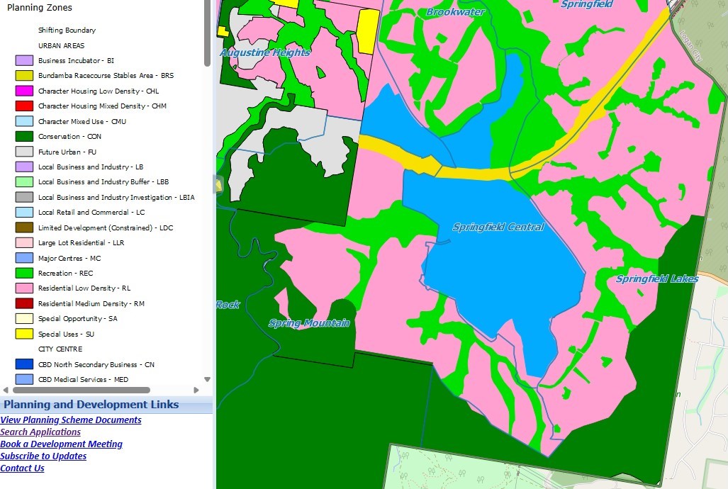
The suburb of Springfield Lakes provides a mix of land uses which emerged through the master-planned development efforts of Lend Lease. Made up of a series of distinct neighbourhoods and villages, these neighbourhoods include Bridgewater Chase (Springfield), Clancy's Crossing (Springfield), The Escarpment (Springfield), Lakeside, Eden's Homestead, Olive Springs, Butterfly Green, The Promenade, Waterside at The Promenade, The Peninsula, The Summit, Aspect, Creekside, Lakes Entrance, Wildflower Ridge, Park Edge, Tea Trees, Central Walk, and The Sanctuary.
Thick mountain forests surround the suburb to the south and northeast, with a variety of waterway corridors running through the suburb to form several lakes, known as Spring Lake, Regatta Lake and Discovery Lake. Marsdenia Lookout provides views from a large hill found in the suburb. Springfield Lakes also provides local retail centres with supermarkets, services, and business establishments. Recreational areas, parks and natural watercourses dot the landscape.
SEQ Regional Plan 2009–2031
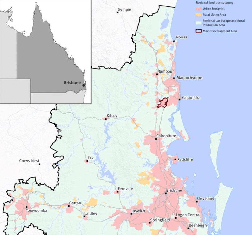
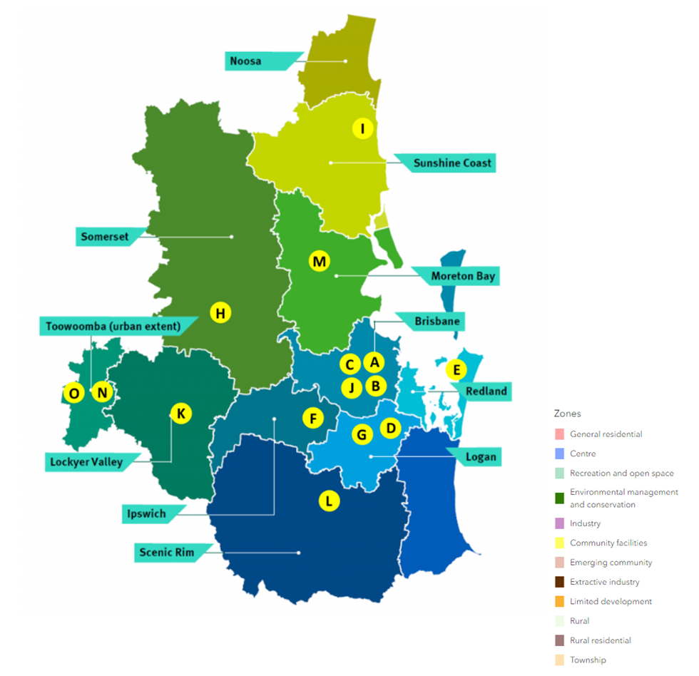
The South East Queensland Regional Plan 2017, also known as ShapingSEQ is a regional plan for South East Queensland (SEQ), Australia and includes Ipswich City Council (urban extent only).
It is a long-term strategic plan that guides land use and development in the region. Developed by the Queensland Government, ShapingSEQ is intended to support sustainable growth and development while protecting the region's natural and cultural heritage. The plan includes policies and guidelines on land use, infrastructure, transport, environment, and economic development.
The plan identifies priority growth areas and development corridors, and sets targets for population growth and housing supply in the region. It also includes strategies for managing urban sprawl, protecting natural resources and biodiversity, and addressing climate change impacts.
The plan also lays out the vision for the region in 2041 which includes a liveable, sustainable, and prosperous region, with a focus on protecting the environment and encouraging sustainable development, as well as improving connectivity and accessibility throughout the region. ShapingSEQ provides a regional framework for growth management and sets the planning direction for sustainable growth, global economic competitiveness, and high-quality living by:
- Identifying a long-term sustainable pattern of development which focuses more on growth in existing urban areas
- Harnessing regional economic strengths and clusters to compete globally
- Ensuring land use and infrastructure planning are integrated
- Valuing and protecting the natural environment, productive land, resources, landscapes, and cultural heritage
- Promoting more choice of housing and lifestyle options
- Locating people and jobs closer together, and moving people and goods more efficiently and reliably
- Promoting vibrant, fair, healthy, and affordable living and housing to meet all the community's needs
- Valuing design and embracing the climate to create high-quality living environments
- Maximising the use of existing infrastructure and planning for smarter solutions for new infrastructure
- Supporting strong rural communities and economic diversification
Regional Growth Management Strategy 2042
The Growth Management Strategy 2042 provides a roadmap for sustainable growth in the region over the next 20 years, aligned with the 'Our Well-Planned Places' goal of the Corporate Plan 2022-2027. It outlines strategic priorities, policies, and actions for short, medium, and long-term outcomes, with a focus on monitoring progress. As one of six central council strategies, it ensures an integrated approach to planning, responding to the South East Queensland Regional Plan 2017. It builds on past achievements, addresses gaps, and responds to housing challenges while preserving local character. Neighbourhood planning and employment opportunities are emphasized, with collaboration being key to its success.
South East Queensland City Deal – Implementation Plan
The Australian Government, Queensland Government, and Council of Mayors (SEQ) are already delivering for local communities throughout South East Queensland. They are focused on commitments that meet four strategic outcomes: accelerating future jobs across SEQ; a faster, more connected SEQ region; a more liveable SEQ; and creating thriving communities for SEQ.
The SEQ City Deal agreement was signed on 21 March 2022 by the Australian Government, Queensland Government and Council of Mayors (SEQ). The accompanying Deal document sets out the vision, objectives, and commitments.
The SEQ City Deal Implementation Plan was released in July 2023 and provides details about how the Deal will be delivered, commitment milestones and funding arrangements. The document identifies the Ipswich City Council area as F (Public Transport Corridor Upgrade).
Initial assessment for a public transport corridor linking Ipswich Central to Springfield Central is underway. This commitment entails conducting an options analysis to explore connectivity between Ipswich City Centre and Springfield Town Centre.
Lendlease – Springfield Lakes Development
Springfield Lakes is a distinguished master-planned community established in 12999 situated within Greater Springfield, the rapidly expanding region of South East Queensland. Encompassing 1200 hectares, it was conceived as a haven for individuals to craft their own lifestyles. Completed in 2020, it swiftly sold out and garnered acclaim for its thoughtful design. With three lakes, 28 parks, and a population of around 30,000 residents, it stands as a testament to its vision.
Ipswich Council Planning Scheme (2024)
The council is responsible for ensuring adequate housing, facilities, infrastructure, and services for new residents and businesses. The city of Ipswich is experiencing rapid growth, with a current population of around 247,000 expected to reach 535,000 by 2046. To address this growth, the Council has developed the Ipswich Plan 2024, a comprehensive planning scheme for the next two decades.
The draft Ipswich Plan 2024 was available for public review from May 15 to July 16, 2023. The council is now in the process of reviewing and considering all submissions received during this period and will compile a report on the consultation.
Revisions to the plan may occur based on feedback and changes in circumstances, such as drafting errors or new planning information. Upon completion of the review process, the plan will be submitted to the state government for final approval, aiming to replace the current 2006 Ipswich Planning Scheme.
We anticipate that the Ipswich Plan 2024 will come into effect in early 2024, contingent on approval from both the state government and the Council.
Youtube - New Ipswich Planning Scheme: Ipswich Plan 2024 (youtube.com)
Springfield Lakes Suburb Summary
References
Lendlease Springfield Lakes
South East Queensland City Deal – Implementation Plan
Regional Growth Management Strategy 2042
Reshaping our region’s planning