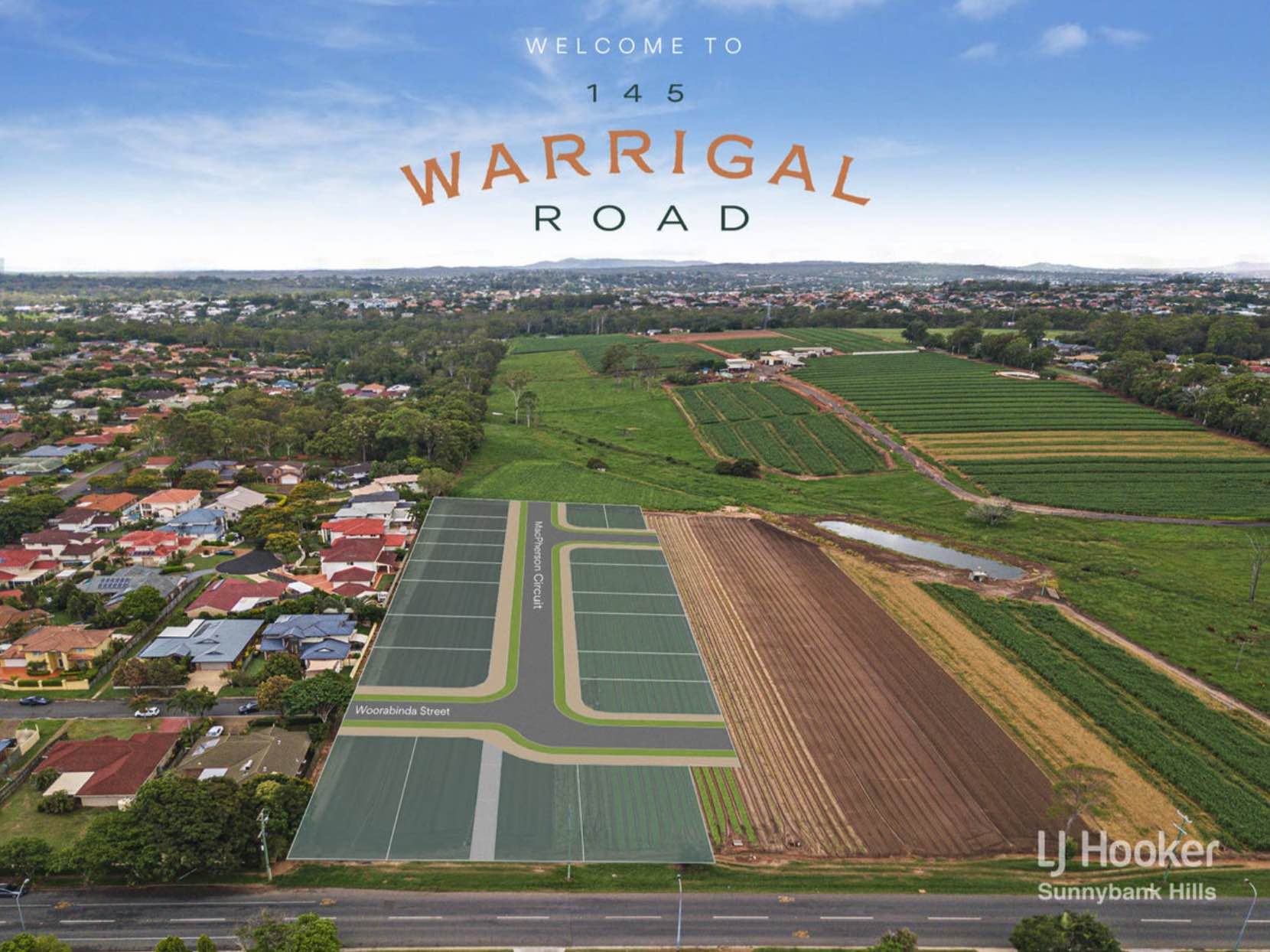
Warrigal Farms Estate - Runcorn SOLD OUT
This information is estimated by the OpenLot research team. Let us know here to provide up-to-date information about this development.
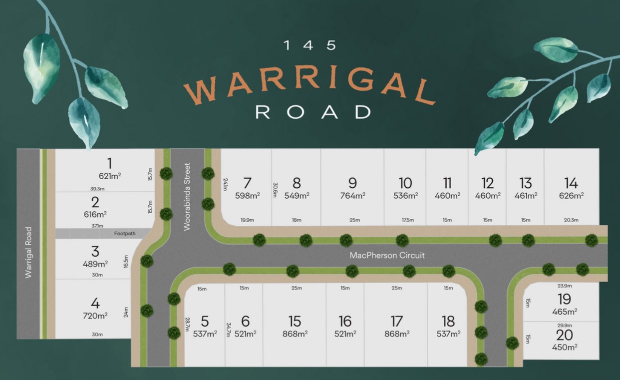
| Total new homes | 254 |
| Area size | 20.38 hectares |
| Growth Region | Greater Brisbane Growth Areas |
| City council | Brisbane City Council |
| Developer | N/A |
| Distance to | Brisbane CBD - 15 km south-east Brisbane Airport - 23 km south |
Popular Estates near Warrigal Farms Estate - Runcorn


Updates for Warrigal Farms Estate - Runcorn
Facebook updates:
Submit the Facebook page for Warrigal Farms Estate - Runcorn.
Related news:
Inspection Available Now! - Lot 1/145 Warrigal Road, Runcorn, QLD 4113 - Residential for sale #5S8PF4R - LJ Hooker Property Partners

CONSTRUCTION has begun on the first stage of a development which would see an iconic Brisbane farm tilled by the same family for more than a century be divided into more than 250 residential lots and ultimately swallowed up.

Warrigal Farms is a landmark in Sunnybank, Brisbane. It has been farmed by the Buyers family for over a century, but as the last remaining...
Missing articles? Send us a link here.
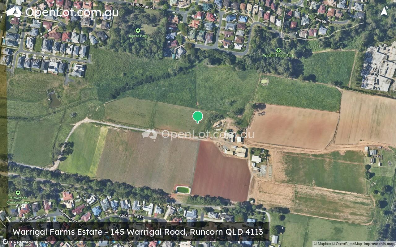
Location & Map for Warrigal Farms Estate - Runcorn
Visit Display Homes near Warrigal Farms Estate - Runcorn


Vacancy Rate in Runcorn QLD 4113
View full vacancy rate history in Runcorn QLD 4113 via SQM Research.
Schools near Warrigal Farms Estate - Runcorn
Here are 6 schools near Warrigal Farms Estate - Runcorn:
Prep-6 Government Primary School
7-12 Government Secondary School
Prep-12 Government Special School
Prep-6 Government Primary School
Prep-6 Government Primary School
Prep-6 Government Primary School
Reviews & Comments on Warrigal Farms Estate - Runcorn
Estate Brochure, Masterplan, Engineering Plan, Plan of Subdivision (POS), Design Guidelines
FAQs about Warrigal Farms Estate - Runcorn
- Warrigal Road State School - 966m north
- Runcorn State High School - 1.1km west
- Kuraby Special School - 1.3km south
- Kuraby State School - 1.5km south-east
- Eight Mile Plains State School - 2.0km east
- Runcorn Heights State School - 2.2km south-west
Popular Estates near Warrigal Farms Estate - Runcorn
Latest New Home Articles for You

18/Mar/2026 | OpenLot.com.au
Queensland: Top 30 Most Searched Housing Developments (February 2026)
If you’ve been exploring housing opportunities across Queensland, Februar...

16/Mar/2026 | OpenLot.com.au
New South Wales: Top 30 Most Searched Housing Developments (February 2026)
If you’ve been considering a move in New South Wales, February 2026 provi...

09/Mar/2026 | OpenLot.com.au
Victoria: Top 30 Most Searched Housing Developments (February 2026)
If you’ve been exploring housing opportunities in Victoria, February 2026...

20/Feb/2026 | OpenLot.com.au
Display Homes at Drouin Fields Estate: A Thriving Community in Drouin
Welcome to Drouin Fields, a place where beauty, space, and modern luxury ...

19/Feb/2026 | OpenLot.com.au
Display Homes at Manor Lakes Esate: A Thriving Waterside Community in Manor Lakes
A place where you can settle in, rather than just settle down. Named for ...

13/Feb/2026 | OpenLot.com.au
🏠 Victoria: Top 30 Most Searched Townhouse Developments – January 2026

11/Feb/2026 | OpenLot.com.au
🏡 Top 30 Most Searched Estates by State - January 2026

10/Feb/2026 | OpenLot.com.au
Victoria: Top 30 Most Searched Housing Developments (January 2026)
If you’ve been considering making a move in Victoria, January 2026 offere...

10/Feb/2026 | OpenLot.com.au
Queensland: Top 30 Most Searched Housing Developments (January 2026)
If you’ve been considering making a move in Queensland, January 2026 offe...