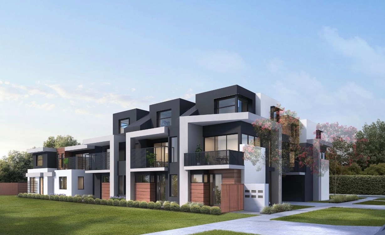

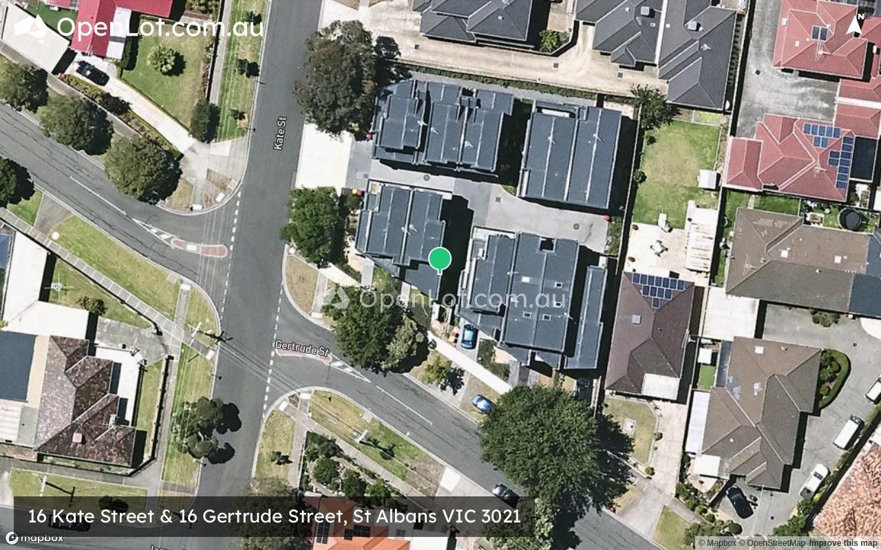
16 Kate Street & 16 Gertrude Street, St Albans VIC 3021 SOLD OUT
This information is estimated by the OpenLot research team. Let us know here to provide up-to-date information about this development.
| Total new homes | 11 |
| Area size | 0.14 hectares |
| Growth Region | Melbourne West Growth Corridor |
| City council | Brimbank City Council |
| Developer | N/A |
| Project marketer | Create VIC Real Estate |
| Distance to | Melbourne Airport - 9 km south-west Melbourne CBD - 17 km north-west |
Townhomes:
Popular Estates near 16 Kate Street & 16 Gertrude Street, St Albans


 4
4
 2
2
 1
1


Updates for 16 Kate Street & 16 Gertrude Street, St Albans
Related news:

Missing articles? Send us a link here.
Location & Map for 16 Kate Street & 16 Gertrude Street, St Albans
Visit Display Homes near 16 Kate Street & 16 Gertrude Street, St Albans


Land Price Trend in St Albans VIC 3021
- In Jan - Mar 23, the median price for vacant land in St Albans VIC 3021 was $653,500. *
- From Apr - Jun 19 to Jan - Mar 23, the median price for vacant land in St Albans VIC 3021 has increased 83.31%. *
- From 2008 to 2022, the median price for vacant land in St Albans VIC 3021 has increased 261.06%. *
Vacancy Rate in St Albans VIC 3021
View full vacancy rate history in St Albans VIC 3021 via SQM Research.
Schools near 16 Kate Street & 16 Gertrude Street, St Albans
Here are 6 schools near 16 Kate Street & 16 Gertrude Street, St Albans:
Prep-6 Government Primary School
7-10 Catholic Secondary School
Prep-6 Catholic Primary School
7-12 Government Secondary School - School Head Campus
Prep-6 Government Primary School
7-12 Government Secondary School - School Head Campus
Reviews & Comments on 16 Kate Street & 16 Gertrude Street, St Albans
Estate Brochure, Masterplan, Engineering Plan, Plan of Subdivision (POS), Design Guidelines
FAQs about 16 Kate Street & 16 Gertrude Street, St Albans
View all estates marketed by Create VIC Real Estate
- St Albans Primary School - 159m north-east
- Catholic Regional College St Albans - 364m east
- Sacred Heart School - 452m north-east
- Victoria University Secondary College - 776m west
- St Albans North Primary School - 1.1km north-east
- St Albans Secondary College - 1.2km south-east
Popular Estates near 16 Kate Street & 16 Gertrude Street, St Albans
Latest New Home Articles for You

09/Mar/2026 | OpenLot.com.au
Victoria: Top 30 Most Searched Housing Developments (February 2026)
If you’ve been exploring housing opportunities in Victoria, February 2026...

20/Feb/2026 | OpenLot.com.au
Display Homes at Drouin Fields Estate: A Thriving Community in Drouin
Welcome to Drouin Fields, a place where beauty, space, and modern luxury ...

19/Feb/2026 | OpenLot.com.au
Display Homes at Manor Lakes Esate: A Thriving Waterside Community in Manor Lakes
A place where you can settle in, rather than just settle down. Named for ...

13/Feb/2026 | OpenLot.com.au
🏠 Victoria: Top 30 Most Searched Townhouse Developments – January 2026

11/Feb/2026 | OpenLot.com.au
🏡 Top 30 Most Searched Estates by State - January 2026

10/Feb/2026 | OpenLot.com.au
Victoria: Top 30 Most Searched Housing Developments (January 2026)
If you’ve been considering making a move in Victoria, January 2026 offere...

10/Feb/2026 | OpenLot.com.au
Queensland: Top 30 Most Searched Housing Developments (January 2026)
If you’ve been considering making a move in Queensland, January 2026 offe...

09/Feb/2026 | OpenLot.com.au
Western Australia: Top 30 Most Searched Housing Developments (January 2026)
If you’ve been considering making a move in Western Australia, January 20...

06/Feb/2026 | OpenLot.com.au
South Australia: Top 30 Most Searched Housing Developments (January 2026)
If you’ve been considering making a move in South Australia, January 2026...