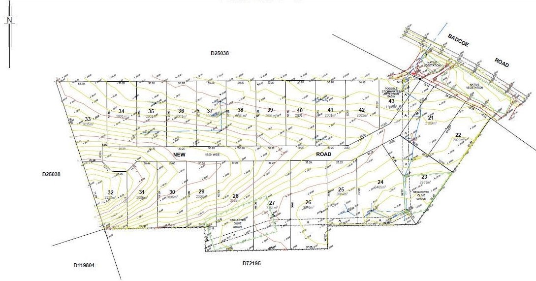

Badcoe Road, Loxton SA 5333
This information is estimated by the OpenLot research team. Let us know here to provide up-to-date information about this development.
| Total new homes | 23 |
| Area size | 5.90 hectares |
| City council | District Council of Loxton Waikerie |
| Developer | N/A |
Land for Sale, House and Land Packages:
Popular Estates near Badcoe Road, Loxton

Angas Views Estate - Angaston

Newbridge Estate - Murray Bridge

Mannum Waters Estate - Mannum

Paddlesteamer Estate - Mannum

The Crossing Estate - Mannum

Dean Semler Drive, Renmark SA 5341

Ridge View Estate - Mannum

Westbrook Fields Estate - Tailem Bend

105-107 Adelaide Road, Mannum SA 5238
Updates for Badcoe Road, Loxton
Location & Map for Badcoe Road, Loxton
Schools near Badcoe Road, Loxton
Here are 6 schools near Badcoe Road, Loxton:
R-6 Catholic Primary School
7-12 Government Secondary School
R-6 Independent Primary School
R-6 Government Primary School
R-6 Government Primary School
R-6 Catholic Primary School
Land Release Applications for Badcoe Road, Loxton
| Land release | Land report | Number of lots | Plan number | Land surveyor | Lodged date | Intended use | Settlement tracking | |||||||||||||||||||||||||||||||||||||||||||||||||||||||||||||||||||||||||||||||||||||||||||
|---|---|---|---|---|---|---|---|---|---|---|---|---|---|---|---|---|---|---|---|---|---|---|---|---|---|---|---|---|---|---|---|---|---|---|---|---|---|---|---|---|---|---|---|---|---|---|---|---|---|---|---|---|---|---|---|---|---|---|---|---|---|---|---|---|---|---|---|---|---|---|---|---|---|---|---|---|---|---|---|---|---|---|---|---|---|---|---|---|---|---|---|---|---|---|---|---|---|---|
| No updates found |
Reviews & Comments on Badcoe Road, Loxton
Estate Brochure, Masterplan, Engineering Plan, Plan of Subdivision (POS), Design Guidelines
FAQs about Badcoe Road, Loxton
- St Albert's Catholic School - 1.6km west
- Loxton High School - 1.9km north
- Loxton Lutheran School - 2.1km north-west
- Loxton Primary School - 2.4km north-west
- Loxton North School - 6.0km north-east
- Our Lady of the River School - 19.6km north
Popular Estates near Badcoe Road, Loxton
Angas Views Estate - Angaston
Newbridge Estate - Murray Bridge
Mannum Waters Estate - Mannum
Paddlesteamer Estate - Mannum
The Crossing Estate - Mannum
Dean Semler Drive, Renmark SA 5341
Ridge View Estate - Mannum
Westbrook Fields Estate - Tailem Bend
105-107 Adelaide Road, Mannum SA 5238
Latest New Home Articles for You

15/Apr/2024
The Power of Co Living Investing
In the latest episode of The Property Now Podcast, hosts Matt Ellul and B...

10/Apr/2024
How Do Mortgages Work?
What is a mortgage broker? How does a mortgage broker get paid? Licensing...

10/Apr/2024
Victoria: Top 30 Most Searched Housing Developments (March 2024)
We're delighted to present the lineup of the top 30 most searched housing...

10/Apr/2024
Queensland: Top 30 Most Searched Housing Developments (March 2024)
In the radiant expanse of Australia's eastern coast lies Queensland, reno...

09/Apr/2024
South Australia: Top 30 Most Searched Housing Developments (March 2024)
South Australia, with its enchanting appeal and rich cultural heritage, e...

09/Apr/2024
New South Wales: Top 30 Most Searched Housing Developments (March 2024)
We have compiled the definitive list of the most sought-after housing dev...

09/Apr/2024
Western Australia: Top 30 Most Searched Housing Developments (March 2024)
If you've ever dreamed of calling Western Australia your home, now's the ...
![[Mar/2024] Top Most Searched Housing Developments in Australia](https://files.openlot.com.au/p/styles/500h/s3/article/Thumbnail%20-%20Top%2030%20Most%20Searched%20Housing%20Developments-5.jpg.webp?itok=yt0VccIK)
08/Apr/2024
[Mar/2024] Top Most Searched Housing Developments in Australia
In March 2024, OpenLot unveils a comprehensive showcase of the top-perfor...

02/Apr/2024
What is a house and land package? ...and are they exclusive?
House and land packages in new home construction, emphasising flexibility...