Ecco Ripley Estate - Ripley SOLD OUT
This information is estimated by the OpenLot research team. Let us know here to provide up-to-date information about this development.
| Total new homes | 4,300 |
| Area size | 194.00 hectares |
| Growth Region | Greater Brisbane Growth Areas |
| City council | Ipswich City Council |
| Developer | Sekisui House |
| Distance to | Brisbane CBD - 33 km south-west Brisbane Airport - 45 km south-west |
Land for Sale, House and Land Packages, Townhomes:
Popular Estates near Ecco Ripley Estate - Ripley


Updates for Ecco Ripley Estate - Ripley
Facebook updates:
Related news:
Our master planned community in Ripley, Queensland, Ecco Ripley represents the modern way of life and puts nature at the centre of the community. Enquire today about Ecco Ripley.
No Cookies

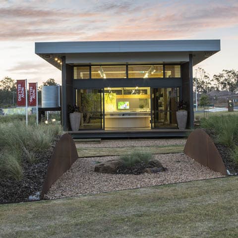
A Residential project completed in Ripley Valley, Queensland for Sekisui House Australia. Find out more...
Homecorp is proud to have been a part of the sustainable building at Ecco Ripley Queensland with a Five Green Star community rating

Missing articles? Send us a link here.
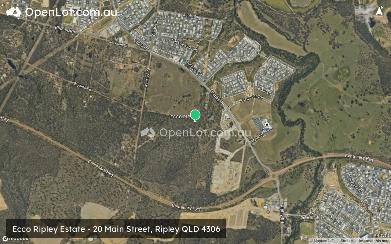
Location & Map for Ecco Ripley Estate - Ripley
Visit Display Homes near Ecco Ripley Estate - Ripley


Schools near Ecco Ripley Estate - Ripley
Here are 6 schools near Ecco Ripley Estate - Ripley:
Prep-6 Government Primary School
7-12 Government Secondary School
Prep-6 Government Primary School
Prep-6 Government Primary School
Prep-6 Government Primary School
Prep-6 Government Primary School
Suburb Planning Review in Ripley QLD 4306
Ripley is approximately 12,800 ha within the city of Ipswich, located 42 kilometres south-west of Brisbane and 7.5 kilometres from Ipswich CBD. The suburb is located in bounded by the Cunningham Highway and Boyland Way to the north, in proximity to the Centenary Highway in the south, Bundamba Creek to the east and Deebing Creek to the west. Ripley Road passes through the centre of the suburb from Flinders View to Ripley South.
The suburb contains large areas of vegetation with sections of cleared and partially cleared land throughout the suburb, separated from the Swan Bank Power Station area to the east by the Bundamba Creek corridor. The existing Ripley Town Centre is located in the south east corner of the suburb accessed by Ripley Road.

Three areas of recreational zoned land are found within the boundaries of Ripley that accommodate parkland, reserves and waterway corridors, which offer walking trails and vegetated creek networks that flow down through the future residential properties.
The large rural residential lots are being developed for smaller lots as the population in South East Queensland expands and the demand for new housing stock rises. Eight new developments in Ripley are, Bellevue Estate, Hayfield Estate, Monterea Estate, Miramor Estate, Cadence Estate, Ripley Valley Estate and the largest being Ecco Ripley Estate.

Ripley Valley
The Queensland State Government introduced the Urban Land Development Act 2007 (ULDA Act) in 2007, which created the Urban Land Development Authority (ULDA) as a state-based planning authority given functions and powers to plan, undertake, coordinate and control the development of identified areas, known as UDAs. The Ripley Valley UDA was declared in October 2010, however, now referred to as a Priority Development Area (PDA) with the commencement of the Economic Development Act 2012 which gave the Minister for Economic Development Queensland (MEDQ).
The Ripley Valley PDA is made up of two (2) areas of Ipswich that covers 4,680 hectares of land located south of Flinders View and Yamanto and west of Swan Bank. The Ripley Valley PDA is surrounded by White Rock Conservation Park to the southeast and Mount Perry Conservation Park to the southwest. The area is expected to provide up to 50,000 new dwellings and take approximately 30-40 years to redevelop.
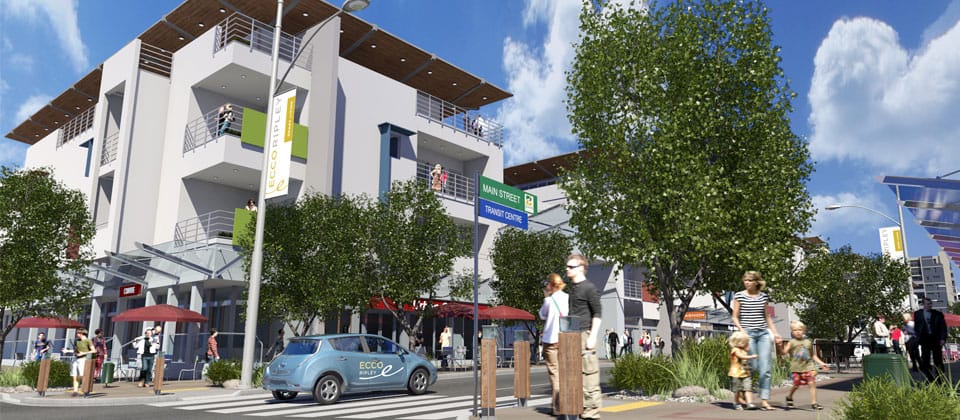
Ipswich City Council’s vision for the region was adopted by the Development Scheme prepared to guide the redevelopment by the ULDA, which contains four new zones, Urban Living, Major Centre, Environmental Protection, Industry and Business. The PDA includes an urban core area called ‘Ripley Central’ that will provide a mix of commercial, business, community, entertainment, retail and higher density development up to 12 storey in height.
It is envisaged that Ripley Valley PDA will provide an urban community (50,000 new dwellings and 120,000 people) with the district, neighbourhood and village centres providing access to employment, services and retail. 13 state primary schools and 5 state high schools are envisaged for the area. A future rail line with several train station stops is envisaged in the long term planning of the area to cater for the new population.

Vision of Ripley
“Ripley Valley 2030 – is a rich and festive community which has developed as a series of distinctive neighbourhoods and smaller villages within the many and varied valley precincts, surrounded both close and afar by hills and views of the iconic Flinders Peak.
Vegetated hills, valleys, lakes, open spaces linkages and trials are a constant reminder of the connection and relationship this community has with its valley home. This natural setting is celebrated by the community in every aspect of design, form and function.
Residents have easy access and connections to employment opportunities both locally and within the wider Ipswich district. Ripley Valley is the heart of one of the State’s employment and economic growth regions, with residents benefiting from employment prospects n neighbouring areas of Swanbank, Ebenezer and Amberley. An integrated public transport system operates within and beyond the Valley to provide convenient travel alternatives. A real ‘sense of place’ is instilled in the Valley, generating community pride in their active involvement in a safe, friendly and green living environment.
The Ripley town centre is stimulating and inspired by its marketplace style and is easily accessible to the community it services. The valley is complimented by a network of smaller neighbourhood mixed use villages offering meeting places, cultural experiences, shopping, recreation, and state of the art transport connections both near and afar. The Ripley Valley has embraced the principles of sustainability and is a model for others to follow – acknowledged both in Australia and overseas”.

Development Themes
The Ripley Valley development scheme follows themes that have been refined to shape the vision statement and prepared in consultation with government, business and the community. The themes guide the development for community living, accessibility, design and function to provide a prosperous and protect valley environment.
Transportation in Ripley
Ripley Valley PDA will provide public passenger transport to Ripley, with bus stops provided to facilitate a bus service through the new community. A potential future rail line and train stations are to be constructed in proximity to the Ripley Town Centre with a passenger train service that connects to Brisbane. The suburb will include a network of shared paths, linking the local parks and conservations parkland to the surrounding and community pathway network.

Ecco Ripley Estate
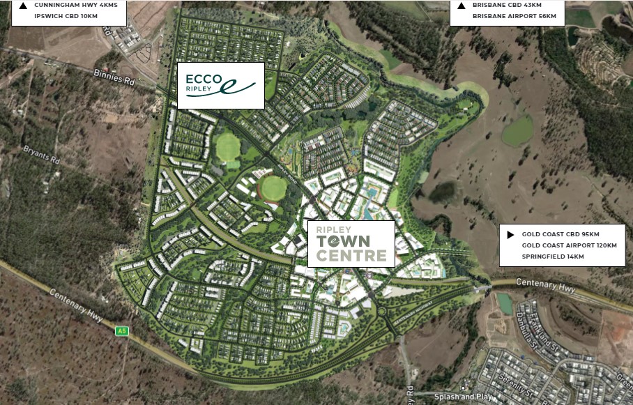
The central portion of the Ripley Valley PDA will be partly redeveloped by Sekisui House which has prepared a $1.5 billion master plan for a substantial parcel of land they have named ‘Ecco’. The master plan includes Ecco Ripley (residential) and Ripley Town Centre (mixed use development) that together provide access to health, commercial, community and retail facilities centred around a future rail station. Located on both sides of the Centenary Highway interchange and future rail station the masterplan provides 40 ha of parkland, local parks and open space in proximity to new residential areas.
The surrounding precincts of the Ripley Valley PDA will provide further social, educational, and community infrastructure, such as South Ripley and surrounding growth areas of Redbank Plains, and Springfield. Local shopping, services and further employment will be found within the Ripley Town Centre and new local centre, including the new Yamanto Town Centre or the Ipswich CBD. The Precinct Structure Plan supports the areas of urban development for higher density residential communities in the Ripley Valley PDA, areas of conservation and rural residential living.
Ripley Suburb Summary
References
ECCO Ripley & Town Centre - Masterplan
Ripley Town Centre
Google Aerial - Ripley
EDQ – Ripley Valley Planning Scheme
Reviews & Comments on Ecco Ripley Estate - Ripley
Estate Brochure, Masterplan, Engineering Plan, Plan of Subdivision (POS), Design Guidelines
FAQs about Ecco Ripley Estate - Ripley
View all estates from Sekisui House
- Ripley Central State School - 1.6km north-west
- Ripley Valley State Secondary College - 2.1km south-east
- Ripley Valley State School - 2.4km south-east
- Deebing Heights State School - 4.4km west
- Raceview State School - 4.7km north
- Amberley District State School - 5.1km north-west
Popular Estates near Ecco Ripley Estate - Ripley
Latest New Home Articles for You

09/Mar/2026 | OpenLot.com.au
Victoria: Top 30 Most Searched Housing Developments (February 2026)
If you’ve been exploring housing opportunities in Victoria, February 2026...

20/Feb/2026 | OpenLot.com.au
Display Homes at Drouin Fields Estate: A Thriving Community in Drouin
Welcome to Drouin Fields, a place where beauty, space, and modern luxury ...

19/Feb/2026 | OpenLot.com.au
Display Homes at Manor Lakes Esate: A Thriving Waterside Community in Manor Lakes
A place where you can settle in, rather than just settle down. Named for ...

13/Feb/2026 | OpenLot.com.au
🏠 Victoria: Top 30 Most Searched Townhouse Developments – January 2026

11/Feb/2026 | OpenLot.com.au
🏡 Top 30 Most Searched Estates by State - January 2026

10/Feb/2026 | OpenLot.com.au
Victoria: Top 30 Most Searched Housing Developments (January 2026)
If you’ve been considering making a move in Victoria, January 2026 offere...

10/Feb/2026 | OpenLot.com.au
Queensland: Top 30 Most Searched Housing Developments (January 2026)
If you’ve been considering making a move in Queensland, January 2026 offe...

09/Feb/2026 | OpenLot.com.au
Western Australia: Top 30 Most Searched Housing Developments (January 2026)
If you’ve been considering making a move in Western Australia, January 20...

06/Feb/2026 | OpenLot.com.au
South Australia: Top 30 Most Searched Housing Developments (January 2026)
If you’ve been considering making a move in South Australia, January 2026...