


Minton Place Estate - Beveridge 2 AVAILABLE
[LIMITED OFFER] Minton Place – 5C Terrace Lots - Now Open for Expressions of Interest from $475k*.
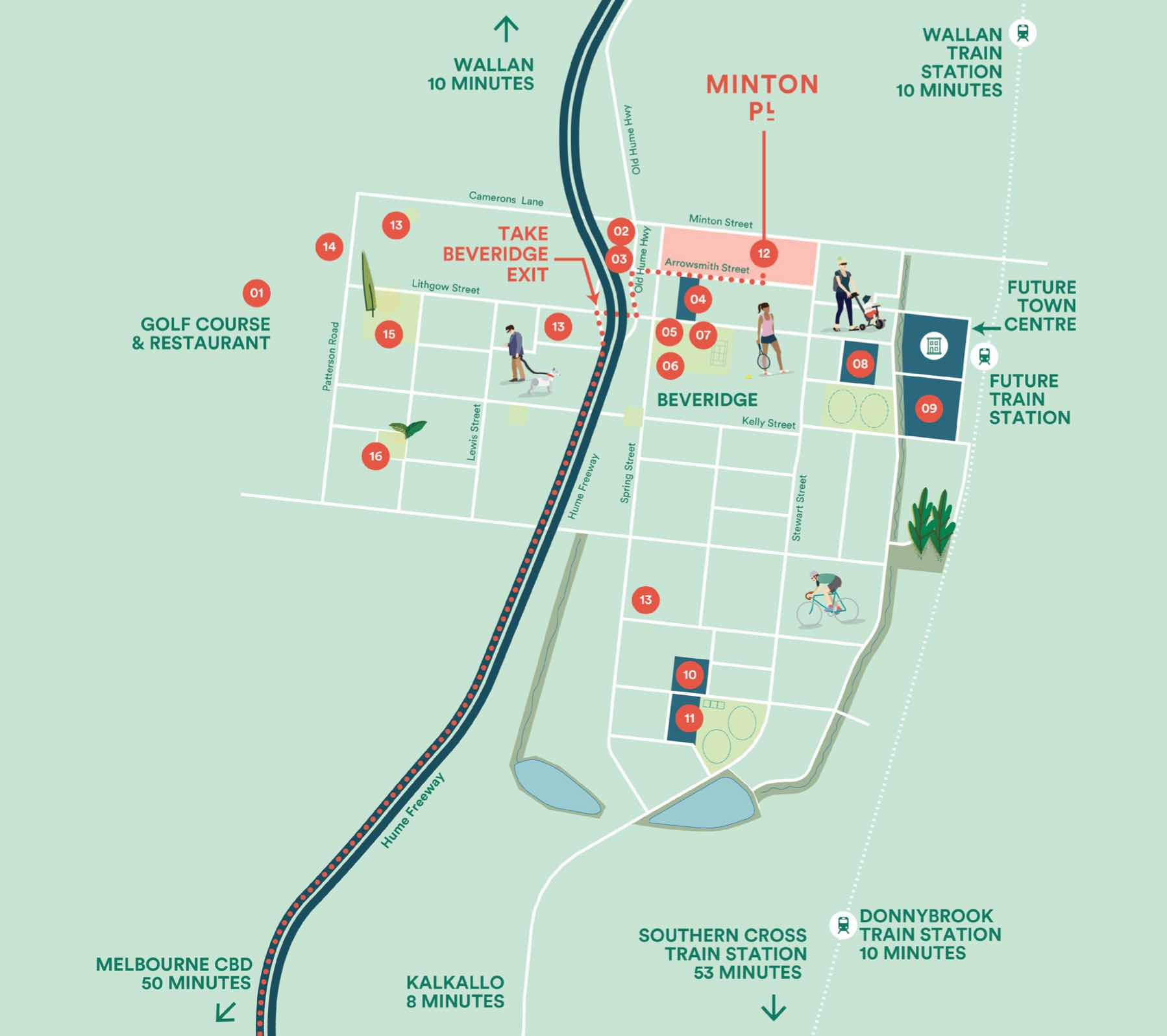
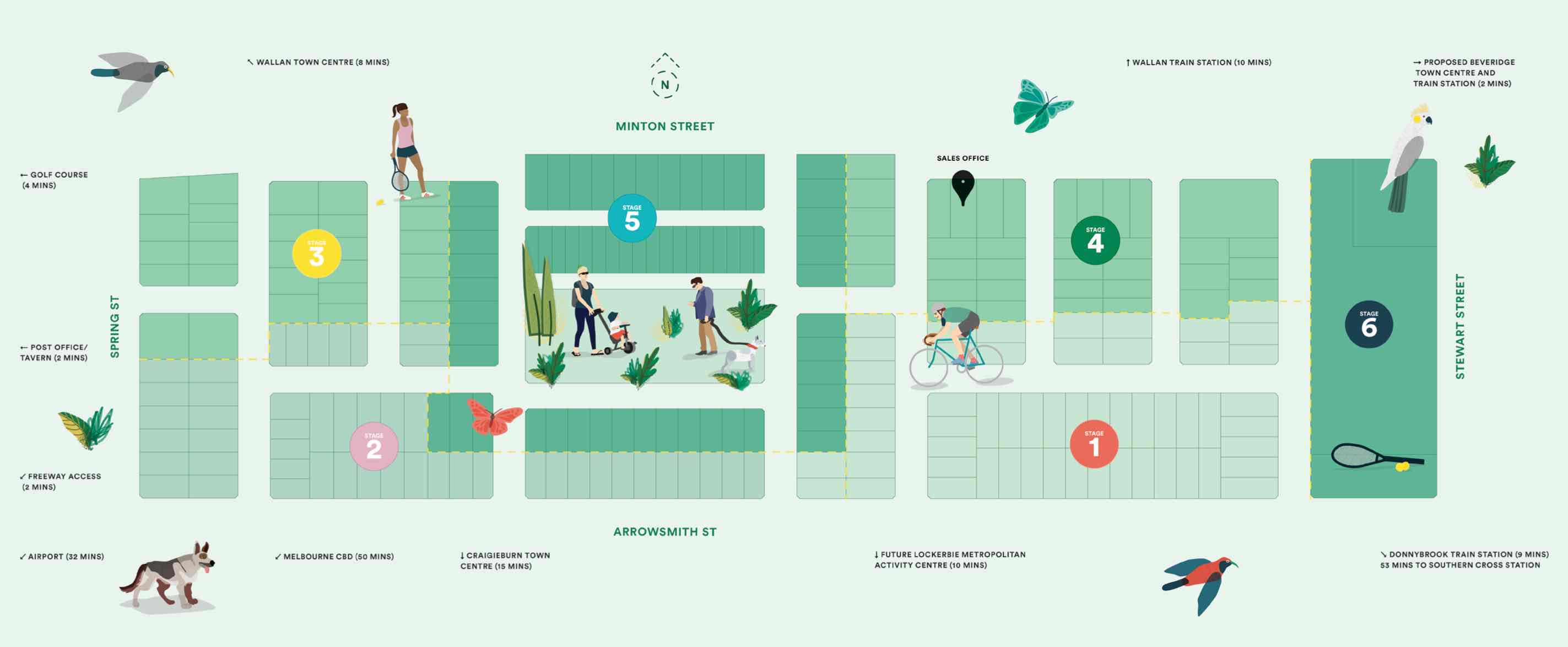
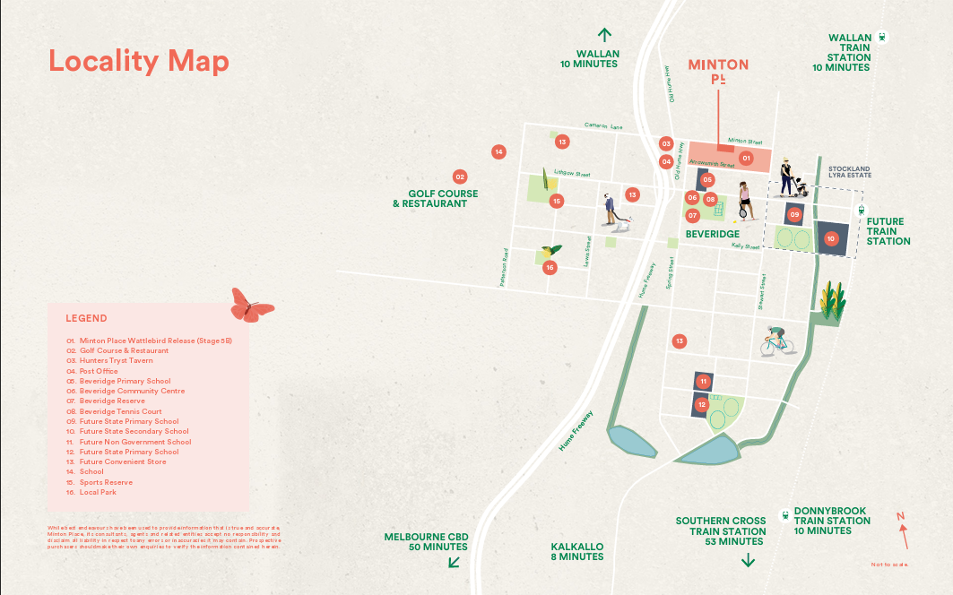
- Wide range of lots - 300m2 - 512m2
- Elevated location & Views of the CBD
- Walking distance to future Beveridge town centre and railway station
- Walking distance to Beveridge Primary School
- 4 minute drive to established golf course
- Easy access to Hume Freeway
- Part of future Beveridge Community, including schools, childcare, retail, cafes and tavern
- 10 min drive to proposed Lockerbie Metropolitan Activity Centre including hospital and university campus
- Close to established shops, restaurants and golf course
This information is estimated by the OpenLot research team. Let us know here to provide up-to-date information about this development.
| Total new homes | 275 |
| Area size | 15.85 hectares |
| Growth Region | Melbourne North Growth Corridor |
| City council | Mitchell Shire Council |
| Developer | Lauders Group, Optimus Developments |
| Project marketer | Lauders Group Project Marketing |
| Creative agency | Placemaker Studio |
| Distance to | Melbourne Airport - 25 km north-east Melbourne CBD - 38 km north |
Land for Sale, House and Land Packages, Townhomes:
House and Land Packages in Minton Place Estate - Beveridge

 4
4
 2.5
2.5
 2
2
Popular Estates near Minton Place Estate - Beveridge


Updates for Minton Place Estate - Beveridge
Facebook updates:
Related news:
Invest in the powerhouse that is Australian residential property.
Minton place SETTING A NEW BENCHMARK Minton Place is the ideal location to imagine and realise your ideal family lifestyle. Its prime position at the top of a hill at Beveridge affords sweeping views in all directions – from Mt Frazer to the Melbourne CBD. Only 50 minutes from the city, Minton Place is close ... Read moreMinton Place

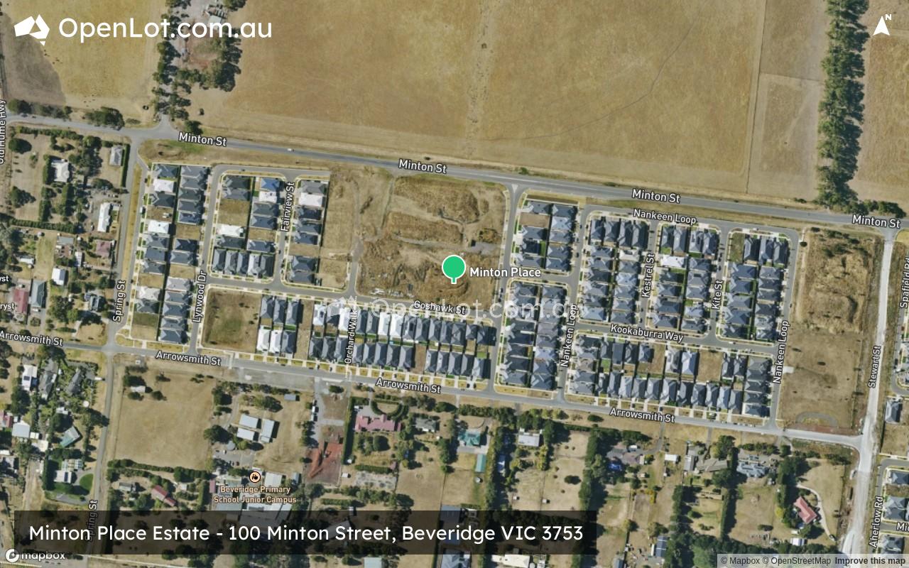
CLIENT: Lauders Group WEBSITE: https://www.lauders.com.au/development/minton-pl/ ADDRESS: 100 Minton Street, Beveridge MUNICIPALITY: Mitchell Shire Council LOTS: 263 YEAR: 2017 – On going Const. cost: $1.8 m (Stage 1) – $6.1 m (Stage 4) Project Description LD Eng worked with Lauders through a due diligence process for serviceability of...

Let’s collaborate Got a project you’d like our help with? Contact Us...

Missing articles? Send us a link here.
Location & Map for Minton Place Estate - Beveridge
Visit Display Homes near Minton Place Estate - Beveridge


Land Price Trend in Beveridge VIC 3753
- In Oct - Dec 24, the median price for vacant land in Beveridge VIC 3753 was $330,000. *
- From Oct - Dec 17 to Oct - Dec 24, the median price for vacant land in Beveridge VIC 3753 has increased 14.98%. *
- From 2008 to 2024, the median price for vacant land in Beveridge VIC 3753 has increased 215.5%. *
Vacancy Rate in Beveridge VIC 3753
View full vacancy rate history in Beveridge VIC 3753 via SQM Research.
Schools near Minton Place Estate - Beveridge
Here are 6 schools near Minton Place Estate - Beveridge:
Prep-6 Government Primary School - School Head Campus
Prep-6 Catholic Primary School
7-12 Government Secondary School
Prep-6 Government Primary School
Prep-6 Government Primary School
Prep-6 Government Primary School
Suburb Planning Review in Beveridge VIC 3753
Beveridge is within the Mitchell Shire, located 42 kilometres north of Melbourne and the rural-residential township forms part of the Urban Growth Boundary. The Beveridge growth area is approximately 291.97ha, which is located to the south and west of the existing Beveridge Township on either side of the Hume Highway.
The new suburb is bounded by the existing Mandalay Estate (Patterson Street) to the west, Camerons Lane to the north, Beveridge Township to the north east, Rankin Street to the south and Stewart Street to the east.
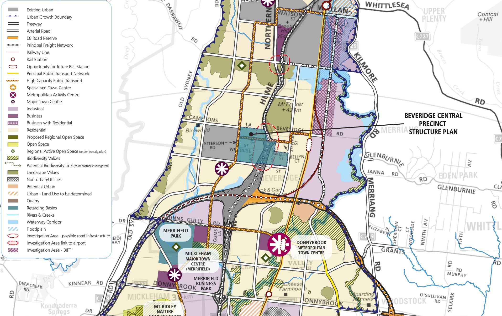
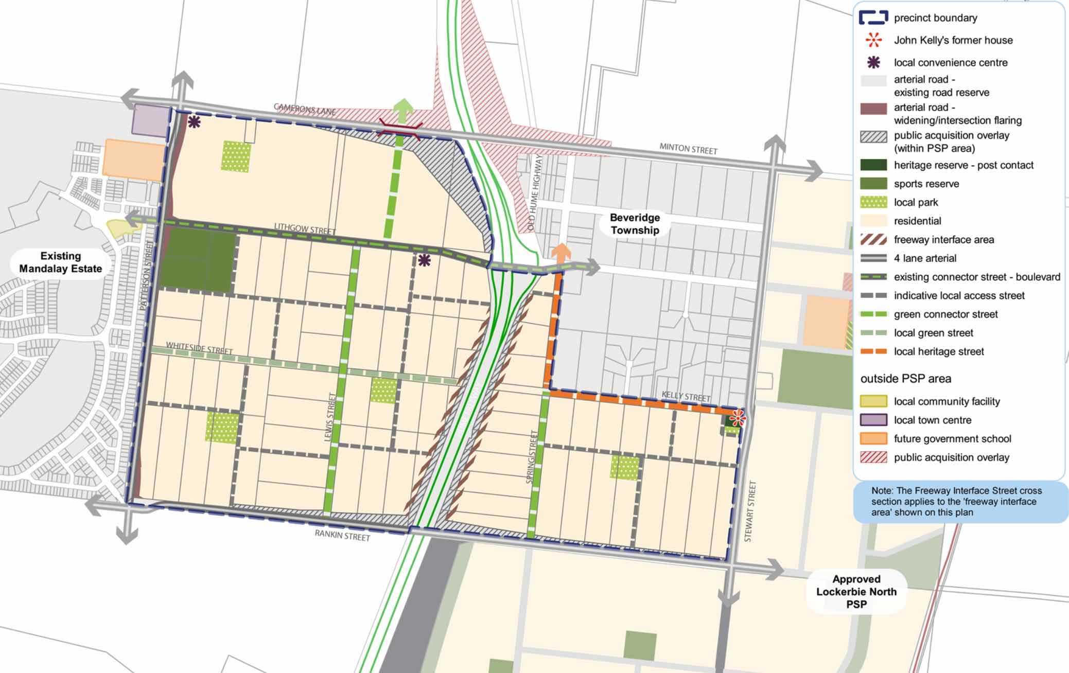
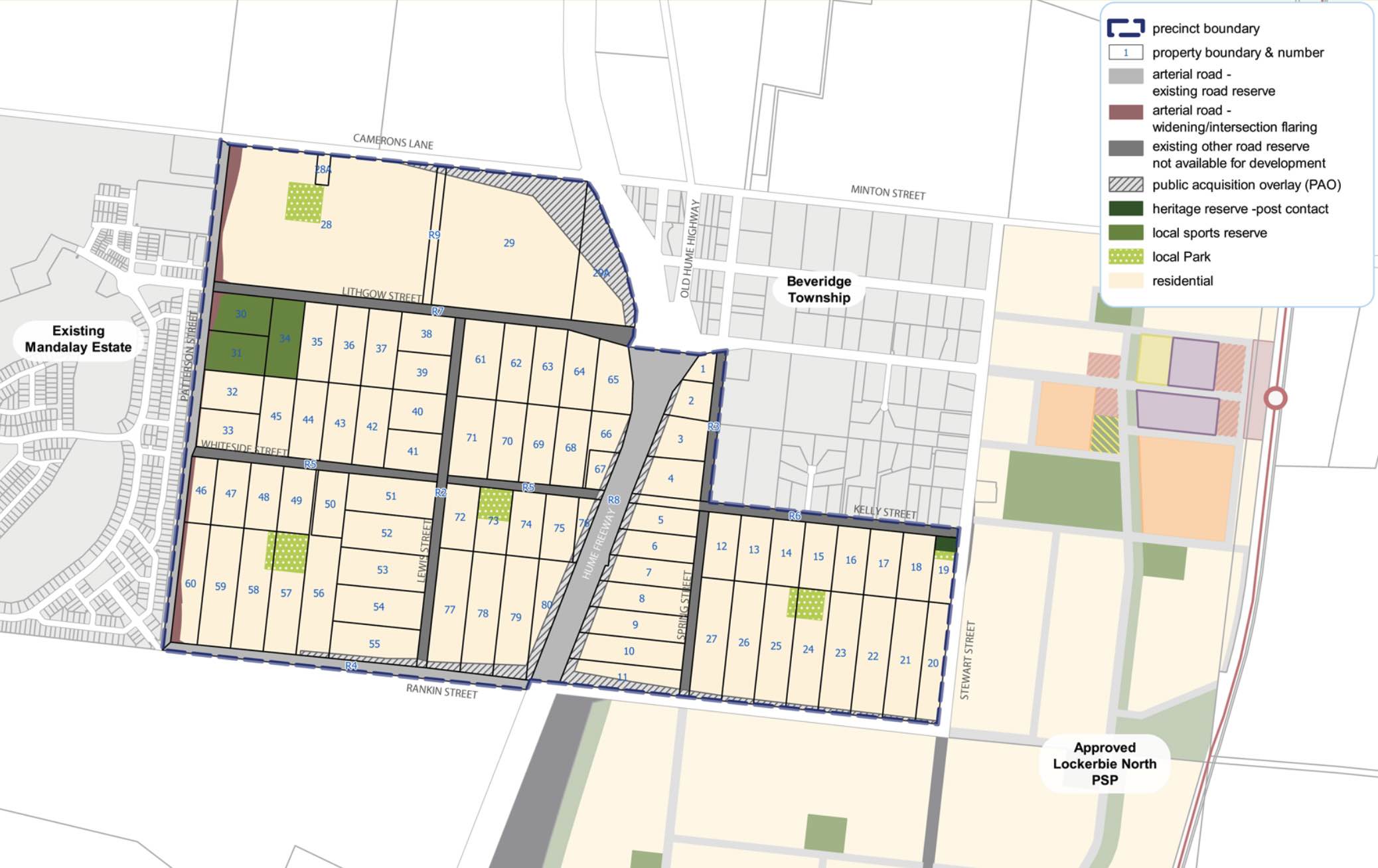
The Beveridge Central Precinct Structure Plan (PSP) was prepared to guide the redevelopment of two future neighbourhoods separated by the Hume Freeway to provide residential neighbourhoods linked by a network of pathways that connect local parks, reserves and convenience centres.
The eastern side of the Hume Highway will integrate with the existing Beveridge Township and the western side will be connected to the existing Mandalay estate and future precincts of Beveridge North-West and Beveridge South-West.
Beveridge also has a current investigation area to the North West of the existing township. The Victorian Planning Authority (VPA) is preparing a draft Beveridge North West Precinct Structure Plan to introduce the amendment into the Mitchell Planning Schemes. The aim is to have the final decision on the PSP shared publicly by August 2022.
The Beveridge Central PSP was prepared by Victorian Planning Authority (VPA) in consultation with the Whittlesea City Council and Mitchell Shire Council and was approved by the Minister for Planning in December 2018. The decision was officially gazetted in January 2019 under Amendment GC55 to the Mitchell and Whittlesea Planning Schemes.
The Vision of Beveridge
“Beveridge Central is a precinct that builds upon the existing sense of community and history of the Beveridge Township while reinforcing its social and physical connections to newer development occurring in this part of the North Growth Corridor”.
“Beveridge Central is expected to change from a rural-residential community into a well serviced, urban community defined by two future neighbourhoods bisected by the Hume Freeway. The eastern side will have a strong relationship with the existing Beveridge Township and development in the Lockerbie North precinct; the western side connecting to the future Beveridge North-West and Beveridge South-West precincts and existing Mandalay estate. There is a focus on creating a high amenity landscape character by featuring extensive landscaping opportunities and green streets within the existing wide road reserves”.
“A cycling and pedestrian path network along streets will connect key destinations such as local parks, the sporting reserve and convenience centres. Highlighting the precinct’s heritage features provides a sense of place for future residents through the preservation and enhancement of Aboriginal and post-contact heritage places and provides mechanisms to ensure the ongoing protection of these places”.
“To service the needs of future residents the precinct will be connected to social and community infrastructure in immediate neighbouring areas. The neighbourhood infrastructure needs of the community will be largely met within the precinct itself, with high quality open spaces and a sports field. Shopping and commercial services will be readily accessible immediately adjacent to the precinct in new town centres in Mandalay and Lockerbie North, with small scale retail needs provided by two local convenience centres within the precinct”.
“In the longer term, the precinct will be accessible to higher-order services, shopping and jobs at the Beveridge Major Town Centre to the southeast of the precinct. Beveridge Central Precinct will have strong transport connections to key destinations via the Hume Freeway, a potential new railway station at Beveridge, and the future Outer Metropolitan Ring (OMR) road, approximately 2km to the south”.
Benefits of Beveridge
The existing zoning will be amended to provide for Urban Growth Zones, providing a series of local parks in proximity to new residential areas and two local convenience centres. The surrounding precincts will provide social, retail and community infrastructure for the new community.
Local shopping, services and employment will be provided within the Beveridge Major Town Centre found in the Beveridge South-West precinct and key industrial employment opportunities within the Northern Corridor.
The Precinct Structure Plan supports the new residential community, protection of heritage places and facilitates the future setbacks for the Hume Highway upgrade.
.jpeg)
Transportation in Beveridge
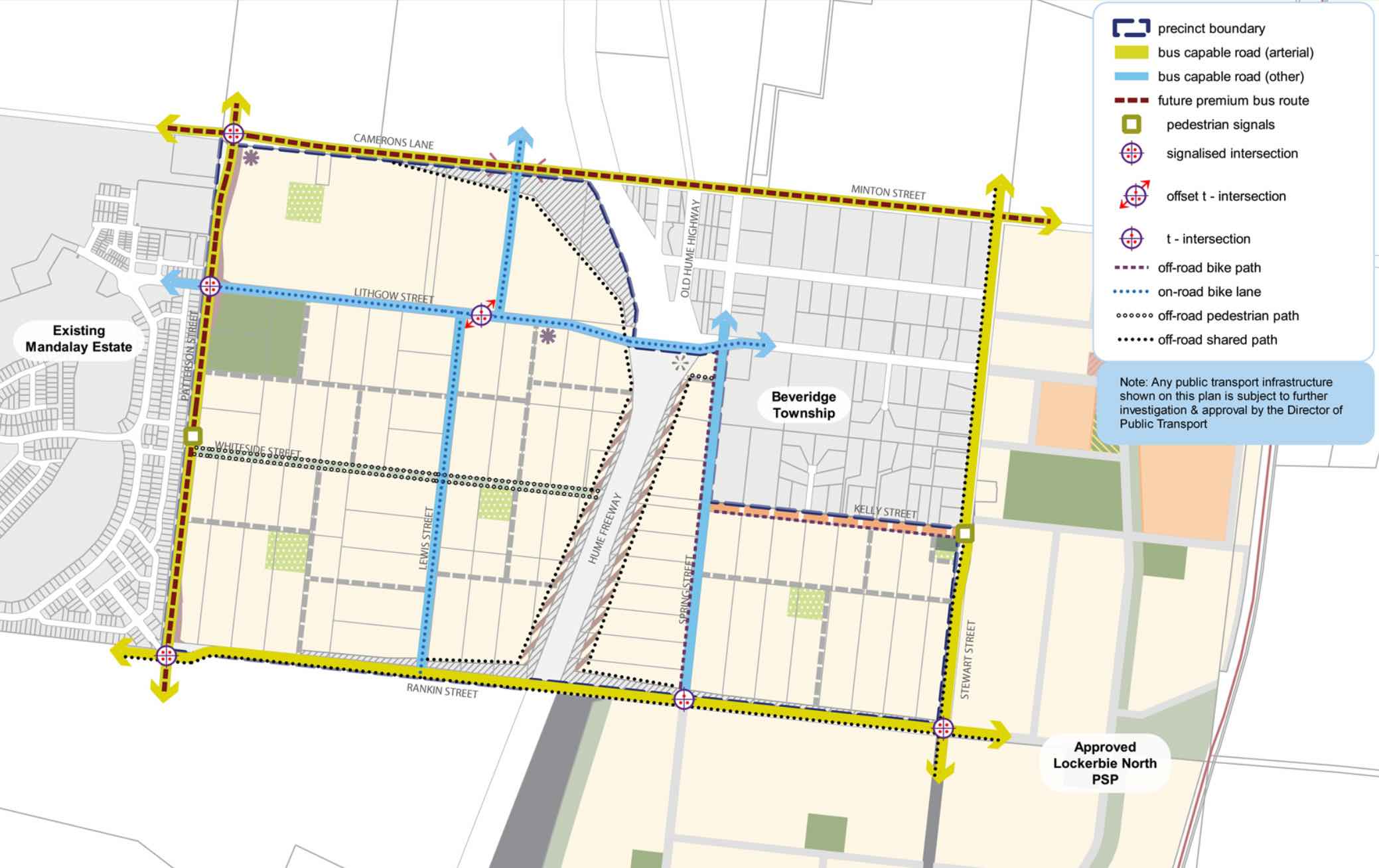
Beveridge will be connected to public passenger transport, with a future train station to be built in Lockerbie, located to the east outside the Beveridge Township boundary. The passenger train service connects Melbourne to Sydney and is being considered for a high speed rail project.
The suburb will include a network of shared paths, linking the local parks and a new road network. Land acquisition is provided to Camerons Lane and Rankin Street to facilitate intersection upgrades to the Hume Highway, providing a direct connection to Melbourne CBD or northern Victoria.
Beveridge Suburb Summary
| Suburb | Beveridge, Mitchell Shire |
| City / State | Melbourne, Victoria |
| Suburb Area | 291.97ha |
| Boundary |
|
| Suburb inclusions |
|
| Community Amenity | Heritage area and general residential area, with local parks |
| Location | North Melbourne, 42 km from Melbourne CBD |
| Education | None |
| Types of Residential |
|
| Employment Areas | Retail and Commercial, Schools, Community Centre |
| Infrastructure |
|
| Transportation |
|
| Recreation Areas |
|
| Heritage |
|
| Settlement Pattern | Green Field |
References
- Mitchell Shire Council
- Victoria Planning Authority – Planning Schemes
- Victoria Planning Authority
- Victoria Planning Authority – Beveridge Central PSP
Reviews & Comments on Minton Place Estate - Beveridge
Estate Brochure, Masterplan, Engineering Plan, Plan of Subdivision (POS), Design Guidelines
FAQs about Minton Place Estate - Beveridge
View all estates from Lauders Group
View all estates from Optimus Developments
View all estates marketed by Lauders Group Project Marketing
- Beveridge Primary School - 290m west
- Our Lady of the Way Catholic Primary School - 5.5km north
- Wallan Secondary College - 5.7km north
- Wallan Primary School - 6.6km north
- Gilgai Plains Primary School - 7.2km south
- Donnybrook Primary School - 7.5km south
Popular Estates near Minton Place Estate - Beveridge
Latest New Home Articles for You

18/Mar/2026 | OpenLot.com.au
Queensland: Top 30 Most Searched Housing Developments (February 2026)
If you’ve been exploring housing opportunities across Queensland, Februar...

16/Mar/2026 | OpenLot.com.au
New South Wales: Top 30 Most Searched Housing Developments (February 2026)
If you’ve been considering a move in New South Wales, February 2026 provi...

09/Mar/2026 | OpenLot.com.au
Victoria: Top 30 Most Searched Housing Developments (February 2026)
If you’ve been exploring housing opportunities in Victoria, February 2026...

20/Feb/2026 | OpenLot.com.au
Display Homes at Drouin Fields Estate: A Thriving Community in Drouin
Welcome to Drouin Fields, a place where beauty, space, and modern luxury ...

19/Feb/2026 | OpenLot.com.au
Display Homes at Manor Lakes Esate: A Thriving Waterside Community in Manor Lakes
A place where you can settle in, rather than just settle down. Named for ...

13/Feb/2026 | OpenLot.com.au
🏠 Victoria: Top 30 Most Searched Townhouse Developments – January 2026

11/Feb/2026 | OpenLot.com.au
🏡 Top 30 Most Searched Estates by State - January 2026

10/Feb/2026 | OpenLot.com.au
Victoria: Top 30 Most Searched Housing Developments (January 2026)
If you’ve been considering making a move in Victoria, January 2026 offere...

10/Feb/2026 | OpenLot.com.au
Queensland: Top 30 Most Searched Housing Developments (January 2026)
If you’ve been considering making a move in Queensland, January 2026 offe...