Donnybrook is located in the Shire of Mitchell, a semi-rural location to the north of Melbourne’s outer suburbs of the Urban Growth Boundary and logical expansion of the former Donnybrook township. Donnybrook growth area is 1,026ha and forms part of the new 1,786ha suburb area (Woodstock and Donnybrook) that is located on either side of Cameron Street.
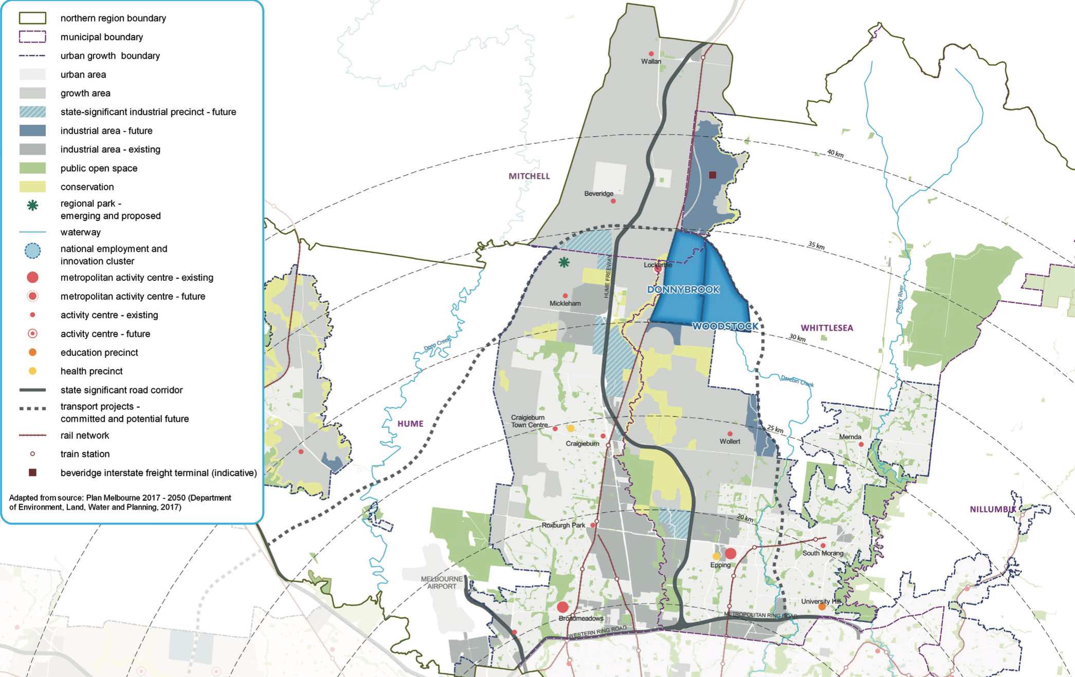
Donnybrook-Woodstock Precinct Structure Plan – Location map
The new suburb is bounded by a possible future high-speed rail investigation area and Outer Metropolitan Ring Reservation (OMR / E6) for future road and rail transport links.
The Donnybrook-Woodstock Precinct Structure Plan (PSP) was prepared to guide the redevelopment of the released land for a mix of residential neighbourhoods linked by a variety of local town centres, schools and other community facilities. Protection of natural assets along the creek corridor and conservation area are provided to protect the Growling Grass Frog habitat from the planned suburb.
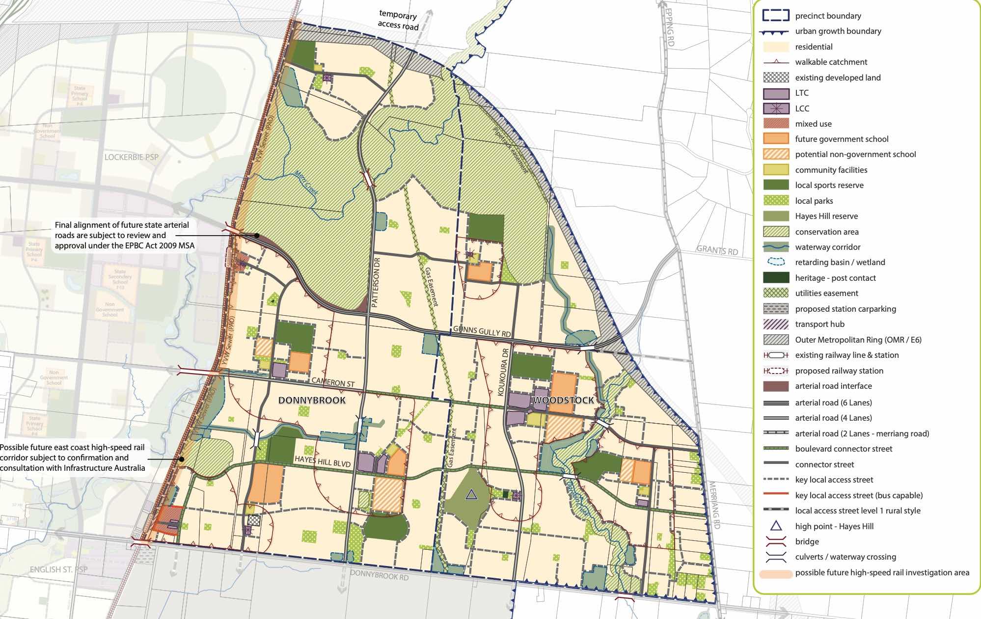
Donnybrook-Woodstock Precinct Structure Plan – Future Urban Structure
The Donnybrook-Woodstock PSP was prepared by Victorian Planning Authority (VPA) in consultation with the Whittlesea City Council and was approved by the Minister for Planning in November 2017. The decision was officially gazetted on 3 November 2017 under Amendment GC28 of the Whittlesea Planning Scheme.
The Vision of Donnybrook
“Development will have a strong emphasis on the retention of natural features and high quality landscaping in an urban environment supported by strong connections to transport and community facilities. Development of the precinct will create a diverse mix of residential neighbourhoods linked by a variety of local town centres, schools and other community facilities.
The distribution of local centres which serve a variety of roles and functions will promote self-sufficiency for residents of the precinct in meeting daily retail and convenience shopping needs. Residential and business development will capitalise on the precinct’s proximity to the existing Donnybrook train station, as well as the future Lockerbie Principal Town Centre and potential future Lockerbie Train Station. The development of the existing Donnybrook Cheese Farm into an agricultural, historical and cultural learning hub will provide new residents with connections to the history of the area”.
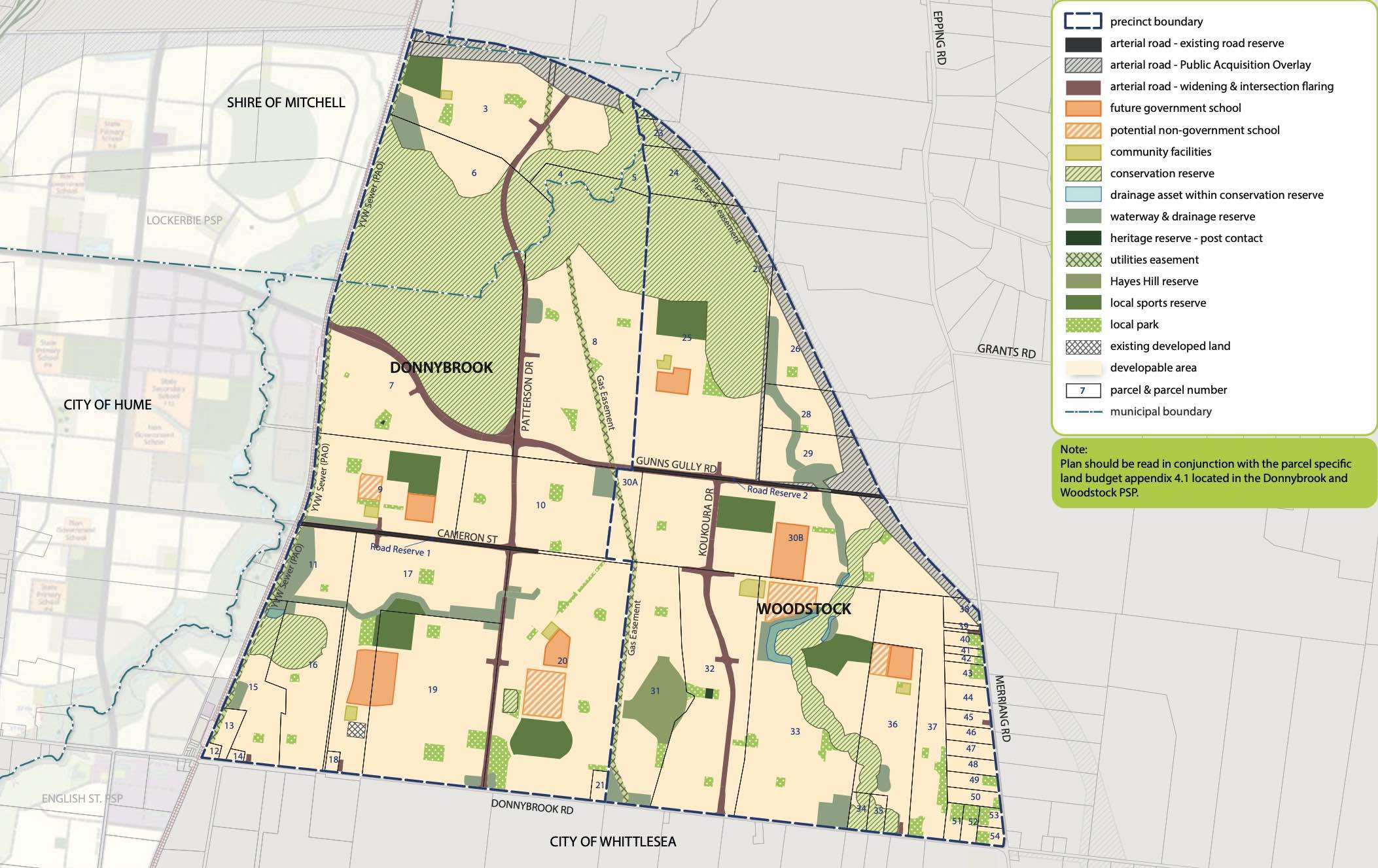
Donnybrook-Woodstock Precinct Structure Plan – Land Use
Benefits of Donnybrook
The Structure Plan also supports new schools, local community hubs, local centres to provide employment and services to the new suburb. The amendments provide a new residential community, protection of natural features, parks, and sports and recreation areas. The existing zoning will be amended to provide for Rural Conservation and Urban Growth Zones, providing a series of greenfield sites in proximity to natural water corridors and reserves.
Transportation in Donnybrook
Donnybrook is well connected to public passenger transport, with a future train station to be in Lockerbie and an existing train station located in Donnybrook train station outside the new suburb boundary. The passenger train service connects Melbourne to Sydney and is being considered for a high speed rail project.
The suburb will include a network of shared paths linking the local parks and a new road network. Donnybrook Road and a new future state arterial road will provide access to the Hume Freeway, providing a direct connection to Melbourne CBD or northern Victoria.
Featured Developments in Donnybrook
 OPENLOT CASHBACK18 AVAILABLELand for Sale Stage 5 Now Selling
Heartford Estate - Donnybrook


Donnybrook Suburb Summary
References
City of Whittlesea - Donnybrook
Victoria Planning Authority – Planning Schemes
Victoria Planning Authority – Donnybrook – Woodstock PSP


