
🏡 Suburb Profile: Wallan
Add as a preferred source on Google
Wallan is approximately 69.6 square kilometres within Mitchell Shire Council, a largely rural location to the north of Melbourne's Central Business District. Wallan contains the northern tip of Melbourne's northern growth corridor and logical expansion of the Wallan township. The suburb is located 45 kilometres north of Melbourne CBD and around 35 kilometres south-east of Seymour, providing a strategic location along the Hume Freeway and Melbourne–Sydney rail corridor.
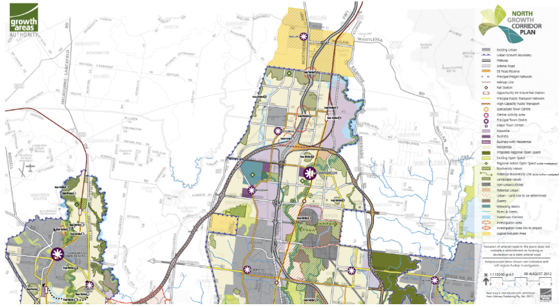
Wallan was recognised as part of the North Growth Corridor Plan, when the south-east portion of township was included as a ‘logical expansion’ in the mapping released in August 2012. This decision incorporated the region into the northernmost extension of the urban growth boundary of the metropolitan area of Geelong, Victoria.
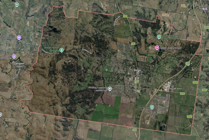
Wallan, VIC - Suburb Aerial
The existing township boundary is located along property boundaries to the North, with Simons Hill Road, property boundaries and Deep Creek corridor making up the western boundary. Property boundaries provide for the southern boundary, with property boundaries, Epping-Kilmore Road, Woodlands Place and Hume Highway providing the eastern boundary.
Darraweit Road, Watson Street, and Wallan-Whittlesea Road provide local road access (east to west), along with Northern Road and Old Sydney Road providing local road access (north to south) throughout Wallan, linking to the Hume Highway interchange that is found in the south-east of the township.
The suburb of Wallan is a large established township, providing residential density centrally and to the south, with rural residential to the north-east, the housing is made up of small- to large-sized properties. The suburb is still mainly rural land, with lakes, bushland dams and inter-connected waterway corridors throughout. Wallan is slowly redeveloping, with new housing estates in the east expanding from the original township.
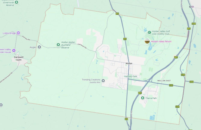
Wallan, VIC – Local Government Areas
Melbourne 2030 (2008 Update) - Victorian Government
In 2002, the Victorian Government's blueprint for managing long-term growth in the surrounding region. The 2008 release of updated population projections in "Victoria in Future 2008" prompts a revaluation of development strategies, ensuring Melbourne remains adaptable. Acknowledging an inevitable population surge, "Melbourne @ 5 million" emphasises readiness and focuses on job creation and service provision in key areas.
The update prioritises preserving liveability and enhancing quality of life. It targets growth towards Melbourne's north and west while exploring expansion possibilities. Moreover, it encourages collaboration with councils to identify suitable redevelopment sites, underscoring the importance of community support for Melbourne's evolution as a top-tier city.
Key Facts
- Melbourne 2030 (2002): Established the Urban Growth Boundary (UGB) to manage expansion
- UGB Purpose: Directs growth to areas with infrastructure while protecting land and environment.
- 2010 UGB Review: Accommodated 600,000 new dwellings, primarily in north and west
- Environmental Assessment: rigorous studies and Commonwealth approval to protect natural features.
- Funding Infrastructure: Introduction of Growth Areas Infrastructure Contribution (GAIC) and improved Development Contribution Plans (DCP).
- 2012 Expansion: Added 6,000 hectares to UGB based on recommendations
Outer Melbourne Northern Suburbs Upgrade
Infrastructure Australia in 2016 identified the need to improve urban transport networks between Melbourne's Outer Northern Suburbs and the CBD, marking it as crucial within a medium-term timeframe of 5-10 years. The proposal aims to address pressing transportation challenges due to rapid growth in the Northern Growth Corridor. With projections indicating significant population and employment increases by 2031, existing road and rail infrastructure faces strain, leading to anticipated congestion and delays along the Hume Freeway and the Seymour Line.
Recognising the urgency, the Victorian and Australian Governments are collaborating on a comprehensive strategy integrating road and rail network planning. Through various projects and proposed reforms outlined in Victoria’s infrastructure strategy 2021-2051, efforts are underway to alleviate congestion and enhance transportation services in the corridor. Emphasising the need to explore diverse options, including infrastructure upgrades and reforms, this proposal seeks to meet the transportation needs of Melbourne's outer northern suburbs' growing population and employment hub.
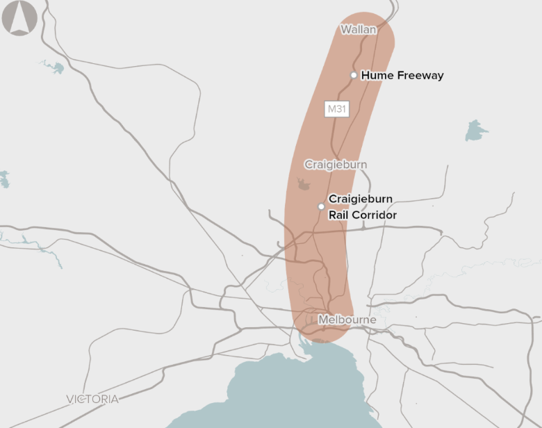
Growth Corridor Plans
The Precinct Structure Plans (PSPs) complement the broader land use framework outlined in the Growth Corridor Plans. PSPs are detailed planning documents that guide development within specific precincts, ensuring they align with the overarching goals of the Growth Corridor Plans. Developed through a consultative process involving stakeholders, PSPs provide a strategic blueprint for neighbourhood development.
In 2012, the Growth Areas Authority (GAA) in collaboration with local councils, PSPs define the pattern for neighbourhood growth, ensuring cohesion and sustainability over time. They play a crucial role in creating attractive, convenient, and sustainable local communities within the broader growth framework.
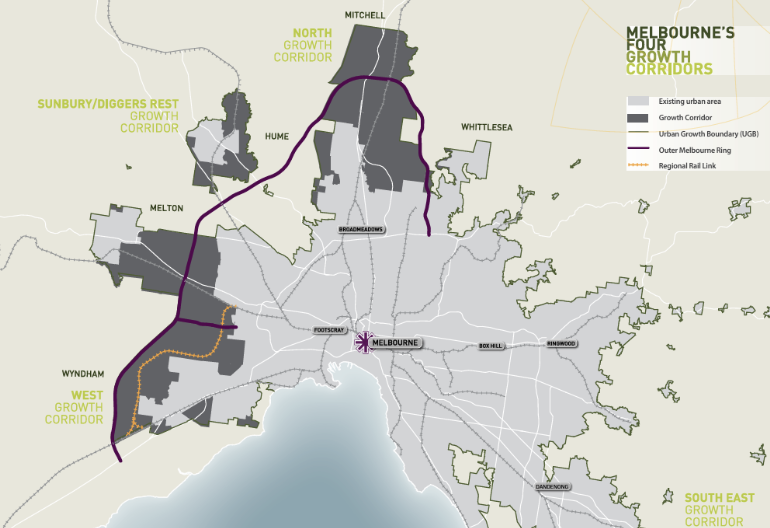
Northern Growth Corridor Plan (Extension)
On 13 June 2012, Planning Minister Matthew Guy announced six new suburbs would be developed on Melbourne’s fringe to accommodate further housing on land in the Green Wedge. Melbourne's growth boundary extended to the north, encompassing parts of the town of Wallan in new detailed growth corridor plans and precinct structure plans.
Precinct Structure Plans
The Growth Areas Authority, in collaboration with the Mitchell Shire Council, government agencies, service authorities, and key stakeholders, has developed the Precinct Structure Plans (PSP) for Wallan. These plans are crafted to steer the redevelopment of designated land, creating interconnected neighbourhoods supported by diverse local town centres, schools, and community facilities. Additionally, measures to safeguard natural assets and conservation areas are incorporated to preserve habitats within the planned suburb.
PSP Relevant to Wallan:
- Wallan South PSP (September 2018) - Paused
Wallan East PSP (Part 1) (July 2020) – Paused.
Wallan East Precinct Structure Plan (Part 1)
The Wallan East and South Precinct Structure Plans form part of the Victorian Government's 10-year plan for Melbourne's greenfield growth areas, which aims to deliver new housing and employment opportunities across Melbourne's expanding growth corridors.
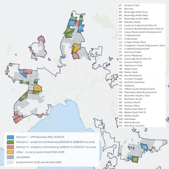
While both were identified as a future growth area, planning has been temporarily paused as it is not included in the Victorian Planning Authority (VPA) Business Plan 2024–25 or the current annual work program. The project has instead been allocated to Horizon 2 of the Government's 10-year greenfield planning pipeline, with planning expected to recommence between 2025–26 and 2028–29.
Importantly, planning for the precinct has already advanced through the co-design stage, meaning the project is well positioned to resume once it returns to the Victorian Planning Authority's active work program. Upon completion, the Precinct Structure Plan will provide the strategic framework for future residential neighbourhoods, supporting infrastructure, transport connections, open space, community facilities and essential services required to accommodate Wallan's long-term growth.
These three future planning areas identified for Wallan will play an important role in supporting the township's continued expansion within Melbourne's northern growth corridor.
Mitchel Shire Council Planning
Despite the PSP being paused, Mitchell Shire Council has to consider the most strategic and best use of the land in the Wallan East PSP area.
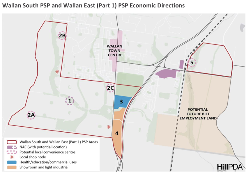
An economic and retail assessment, prepared by HillPDA Consulting (updated 2022), has been prepared to support the future planning of the Wallan South and Wallan East (Part 1) Precinct Structure Plan (PSP) areas, which form part of the broader Wallan growth corridor within Mitchell Shire. The assessment provides guidance on future housing, employment, retail services and community infrastructure required to support Wallan's long-term growth. At full development, Wallan is expected to accommodate approximately 19,800 dwellings and a population of around 61,300 residents.
To support this future population, the township is projected to require a significant expansion of commercial and employment infrastructure, including:
- Approximately 115,700 square metres of retail floorspace across Wallan's activity centres.
- Approximately 34,700 square metres of office floorspace.
- Around 51 hectares of industrial land.
- Additional health, education and community facilities to support a growing population.
The assessment identifies Wallan Town Centre, Wallara Waters and the proposed Wallan South Employment Precinct as important locations for future commercial, employment and higher-order services.
Wallan South Precinct
The Wallan South PSP area covers approximately 806 hectares and is planned to become a major residential and employment precinct.
At full development, the precinct is expected to deliver:
- Approximately 7,000 new homes.
- A population of around 21,800 residents.
- A Neighbourhood Activity Centre providing retail and community services.
- Two to three Local Convenience Centres supporting surrounding neighbourhoods.
- An employment precinct incorporating commercial, health, education, showroom, bulky goods and service industry uses.
The employment precinct will provide opportunities for local jobs and support Wallan's role as a major regional township.
Wallan East (Part 1) Precinct
The Wallan East (Part 1) PSP area covers approximately 140 hectares and will provide additional residential growth east of the existing township.
At full development, the precinct is expected to accommodate:
- Approximately 2,250 new homes.
- A population of around 7,000 residents.
- A Local Convenience Centre providing essential retail services for future residents.
Future Role of Wallan
The planned growth of Wallan South and Wallan East (Part 1) will contribute to the township's transformation into a larger, more self-sufficient community. The delivery of new residential areas, employment precincts, retail centres and community infrastructure will support population growth while improving local access to jobs, services and facilities.
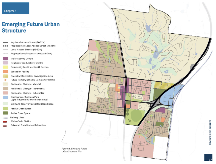
Wallan Structure Plan
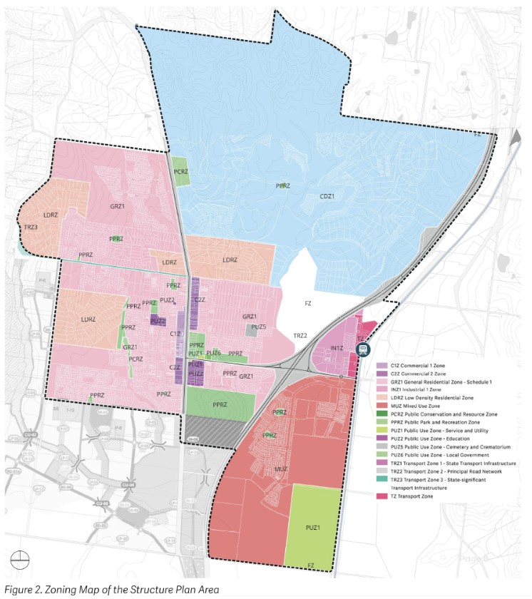
The Wallan Structure Plan provides a long-term strategic framework to guide the growth of Wallan as one of Melbourne's northern growth areas. It establishes a vision for accommodating a rapidly expanding population while ensuring that housing, employment, infrastructure, transport and community services develop in a coordinated and sustainable manner.
The Structure Plan seeks to transform Wallan from a commuter town into a more self-sufficient regional centre by:
- Supporting well-planned residential growth.
- Strengthening the town centre as Wallan's primary commercial, retail and civic destination.
- Increasing local employment opportunities.
- Delivering infrastructure in step with population growth.
- Protecting environmental assets and landscape character.
- Creating connected neighbourhoods with high-quality public spaces.
Growth and Land Use
The plan recognises that Wallan will continue to experience significant population growth and identifies areas suitable for future urban expansion. It promotes a balanced mix of housing, employment land, retail, community facilities and open space to support a complete and liveable community.
Town Centre
A key focus is enhancing the existing town centre by encouraging:
- Additional retail and commercial development.
- Mixed-use development opportunities.
- Improved pedestrian connections and public spaces.
- Greater civic and community activity.
- Reduced reliance on the Northern Highway as the town's main commercial spine.
Employment
The Structure Plan aims to improve local job opportunities by:
- Supporting industrial and commercial land development.
- Encouraging business investment.
- Reducing dependence on commuting to Melbourne.
- Promoting a more diverse local economy.
Transport and Movement
Improving connectivity is a major objective, including:
- Upgrades to the arterial road network.
- Better integration between new growth areas and the existing township.
- Improved walking and cycling infrastructure.
- Enhanced public transport access.
- Planning for increased traffic generated by future development.
Community Infrastructure
The plan identifies the need for additional:
- Schools and education facilities.
- Community centres.
- Sporting and recreation facilities.
- Parks and open space.
- Health and social infrastructure.
Infrastructure planning is intended to occur alongside residential growth to maintain community liveability.
Environment and Water Management
The Structure Plan seeks to:
- Protect waterways and drainage corridors.
- Preserve areas of environmental significance.
- Incorporate integrated water management.
- Improve flood resilience.
- Retain important landscape features where possible.
Relationship to the PSPs
The Structure Plan establishes the strategic vision for the whole of Wallan, while the Wallan South PSP and Wallan East (Part 1) PSP provide the detailed statutory planning framework for the designated growth precincts.
The PSPs largely implement the Structure Plan's objectives through:
- Detailed land use planning.
- Road and transport layouts.
- School and community facility locations.
- Open space networks.
- Drainage infrastructure.
- Development staging.
As the PSPs are more recent and more detailed, they should generally be regarded as the current planning framework for their respective precincts, while the Structure Plan continues to provide the overarching strategic context for Wallan's future growth.
The Wallan Structure Plan presents a coordinated vision for managing long-term urban growth by balancing residential development with employment, infrastructure, transport and environmental protection. Its strategic objectives are broadly reflected in the more recent Wallan South and Wallan East PSPs, which provide the detailed implementation framework needed to deliver that vision on the ground. Together, the documents support Wallan's evolution into a well-connected, self-sufficient and sustainable regional growth township.
Wallan Town Centre Masterplan and Urban Design Framework (Draft, June 2016)
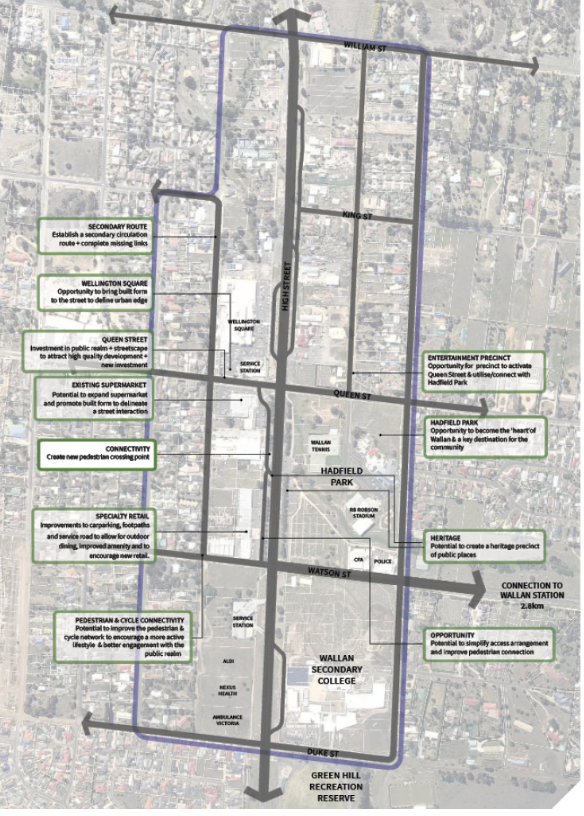
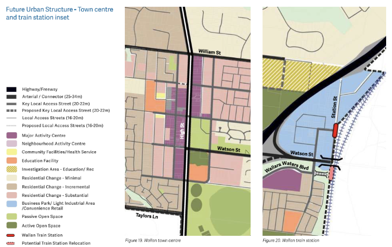
The Wallan Town Centre Masterplan and Urban Design Framework was prepared for Mitchell Shire Council following completion of the Wallan Structure Plan. It provides a detailed vision for transforming Wallan Town Centre into a vibrant Major Activity Centre that can support the township's rapidly growing population.
The document focuses on improving the town centre's economic performance, public spaces, urban design and connectivity, while providing guidance for future planning decisions and investment.
The document focuses on improving the town centre's economic performance, public spaces, urban design and connectivity, while providing guidance for future planning decisions and investment.
The Masterplan aims to:
- Create a long-term vision for Wallan Town Centre.
- Support implementation of the Wallan Structure Plan.
- Revitalise the existing commercial core.
- Improve the public realm and pedestrian experience.
- Guide future development through urban design principles.
- Inform future planning scheme amendments and capital works.
Vision
The Masterplan seeks to create a town centre that is:
- The commercial and civic heart of Wallan.
- Attractive, walkable and people focused.
- Economically diverse and resilient.
- Well connected by streets, paths and public spaces.
- Supported by high-quality urban design.
- Capable of accommodating future residential and commercial growth.
The Wallan Town Centre Masterplan and Urban Design Framework provide a long-term vision for revitalising Wallan’s town centre and strengthening its role as a Major Activity Centre. Prepared for Mitchell Shire Council, the document builds upon the objectives of the Wallan Structure Plan by identifying opportunities to improve the centre’s economic performance, urban design quality, public spaces and connectivity to support future population growth.
The report identifies several challenges within the existing town centre, including limited retail diversity, vacant commercial spaces, poor pedestrian connections, fragmented public spaces and a town layout that is heavily focused on vehicle movement rather than pedestrian activity. It recognises the need for Wallan to evolve into a more vibrant, attractive and accessible destination that can better serve the growing local population.
The Masterplan recommends a range of improvements, including creating stronger civic spaces, improving streetscapes, encouraging mixed-use and residential development, increasing employment opportunities, enhancing walking and cycling connections, and improving the overall quality of buildings and public areas. A key focus is transforming the town centre from a traditional highway-based shopping strip into a more connected, people-focused community hub.
The document supports the broader strategic direction established through the Wallan Structure Plan and aligns with the growth anticipated through the Wallan South and Wallan East PSPs. As Wallan continues to expand, the Masterplan provides a framework to guide investment, redevelopment and infrastructure improvements to ensure the town centre remains the commercial, social and civic heart of the township.
Featured Developments in Wallan
-
 OpenLot Cashback
 LIMITED OFFER: As little as $6K deposit could get First Home Buyers started with a house & land package*Springridge Estate - WallanVacant land House & land
Wallara Waters Estate - Wallan
 NEW RELEASE: The ideal setting for your new home | Lots from $345,000*Wallara Waters Estate - WallanVacant land House & land
Kingsley Place Estate - Wallan
 LIMITED OFFER: ONLY 3 LOTS LEFT - NOW TITLED!Kingsley Place Estate - WallanVacant land


Suburb Summary
References
- Mitchell Shire Council – Wallan Structure Plan
Wallan Structure Plan – Mitchell Shire Council Mitchell Shire Council – Wallan Town Centre Masterplan and Urban Design Framework
Wallan Town Centre Plan and Urban Design Framework – Mitchell Shire Council
- Victorian Planning Authority (VPA) – Wallan East Precinct Structure Plan (Part 1)
Wallan East PSP (Part 1) – Victorian Planning Authority Mitchell Shire Council – Wallan Project Hub / Planning Documents
- Australian Bureau of Statistics (ABS) – Census Data (Wallan)
Australian Bureau of Statistics – Census Data - Victorian Planning Authority – Precinct Structure Planning Framework
Victorian Planning Authority – Precinct Structure Plans Public Transport Victoria / PTV – Wallan Station and Public Transport Information
- Mitchell Shire Council – Community Facilities, Recreation and Open Space Information.
Mitchell Shire Council