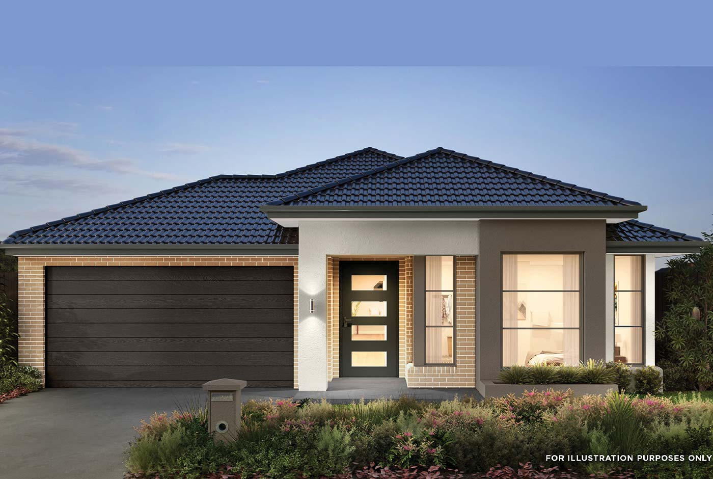


Lot 828: ATTICA 25 @ Balmoral Estate - Strathtulloh VIC 3338
- Double Glazed Windows (Design Specific).
- TITLED LAND
- 20mm Stone Benchtops Throughout.
- 22.5 Degree Roof Pitch.
- 2590mm High Ceilings Throughout.
- Ducted Heating.
- Evaporative Cooling.
- Flyscreens To All Openable Windows.
- LED Tri-Colour Downlights Throughout.
- Glazed Porcelain Tiles To All Wet Areas (Including Showerbase).
- Soft Closing Drawers & Doors To All Cabinets.
- Tile Splashback To Kitchen.
- 215L Heat Pump Hot water Service.
- Coloured Concrete Driveway
 4
4
 2
2
 2
2
Development Info of Balmoral Estate - Strathtulloh

This information is estimated by the OpenLot research team. Let us know here to provide up-to-date information about this development.
| Total new homes | 1,200 |
| Area size | 52.00 hectares |
| Growth Region | Melbourne West Growth Corridor |
| City council | Melton City Council |
| Developer | N/A |
| Project marketer | Melrose Land Sales |
| Creative agency | Ivy Street |
| Distance to | Melbourne Airport - 21 km west Melbourne CBD - 33 km west |
Location & Map for Balmoral Estate - Strathtulloh
Visit Display Homes near Balmoral Estate - Strathtulloh


More House and Land Packages in Balmoral Estate - Strathtulloh
More House and Land Packages by Aston Homes (Home Builder)
 3
2
1
3
2
1
. Tiles/Laminate flooring in living areas
. LED downlights throughout the House
. 2.6kw Solar System
. Double-glazed Glazed Windows.
. 20mm Stone Benchtops Throughout.
. Feature Cabinetry To Kitchen and Bathrooms.
. Glazed Porcelain Tiles To All Wet Areas (Including Showerbase).
. Site Costs Included (Subject to T&C's).
. Soft Closing Drawers & Doors To All Cabinets.
· Tile Splashback To Kitchen.
. Coloured Concrete Driveway
. Ducted Heating & Cooling System: split system air-conditioner
. THE MEGA SALE PROMOTION - $15K OFF Applied
. Dishwasher
. TITLES - April 2026
4
2
2
- Double Glazed Windows.
- 20mm Stone Benchtops Throughtout.
- 22.5 Degree Roof Pitch.
- 2590mm High Ceilings Throughtout.
- LED Tri- Colour Downlights Throughout.
- Glazed Porcelain Tiles To All Wet Areas (Including Showerbase ).
- Soft Closing Drawers & Doors To All Cabinets.
- Tile Splashback To Kitchen.
- Heating And Cooling
- Amazing 4.8 Star On Product Review.
Land Price Trend in Strathtulloh VIC 3338
- In Oct - Dec 24, the median price for vacant land in Strathtulloh VIC 3338 was $299,000. *
- From Oct - Dec 17 to Oct - Dec 24, the median price for vacant land in Strathtulloh VIC 3338 has increased 75.06%. *
- From 2011 to 2024, the median price for vacant land in Strathtulloh VIC 3338 has increased 120%. *
Vacancy Rate in Strathtulloh VIC 3338
View full vacancy rate history in Strathtulloh VIC 3338 via SQM Research.
Schools near Balmoral Estate - Strathtulloh
Here are 6 schools near Balmoral Estate - Strathtulloh:
Prep-6 Government Primary School
Prep-6 Government Primary School
Prep-6 Catholic Primary School
Prep-6 Government Primary School
Prep-6 Catholic Primary School
7-12 Government Secondary School
Suburb Planning Review in Strathtulloh VIC 3338
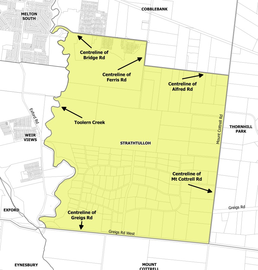
Strathtulloh is with the City of Melton located 40 kilometres west of Melbourne and named after a heritage-listed property located on Greigs Road. Strathtulloh is approximately 1,093 ha, which is bounded by Mount Cottrell Road to the west, Toolern Creek natural waterway corridor to the east, Alfred Road, Ferris Road and Bridge Road to the north and Greigs Road West to the south.
Strathtulloh was gazetted by the Office of Geographic Names on 9 February 2017 under the direction of the Victorian State Government, following a proposal for 11 new suburbs by the City of Melton. The new suburbs have strict density changes to ensure density does not exceed 20,000 residents, ensure vibrant community neighbourhood hubs, provide affordable housing and maintain the geographic characteristics.
The suburb is made up of two parts (northern and southern), as listed below:
- The northern area is set to be redeveloped under the Toolern Precinct Structure Plan which will provide schools, parks and new residential dwellings with an increased density; and
- The southern area known as ‘Strathtulloh Estate’ is a low/semi-rural density area with agriculture surrounded by bushland which will remain undeveloped
.jpg)
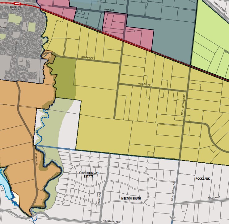
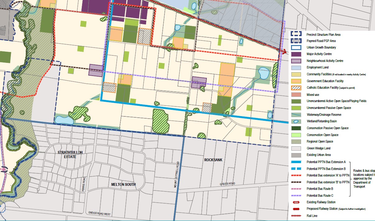
Strathtulloh contains zones that maintain the development intentions of the planning scheme. The Green Wedge Zone (GWZ) is found in the southern portion of the area, the Public Park / Recreation Zone (PPRZ) and Rural Conservation Zone (RCZ) are both located along the western boundary and adjoins the Toolern Creek Park corridor.
The Toolern Precinct Structure Plan includes the Urban Growth Zone (UGZ) located in the northern area of Strathtulloh and enables Melton Shire Council to provide a range of physical and social infrastructure as part of the development of the area, with further infrastructure to be provided by the redevelopment of the new suburb.
The Toolern Precinct Structure Plan (PSP) provides recreation and residential infrastructure necessary to support the long-term strategic planning direction for a more sustainable growth area. The new growth area of Cobblebank-Strathtulloh is expected to provide for over 35,000 people by 2051.
The Toolern PSP was prepared by Victorian Planning Authority (VPA) in consultation with the City of Milton and was approved by the Minister for Planning in October 2010. The decision was officially gazetted in November 2011 under Amendment CO84 (Part 1) to the Milton Planning Scheme. The Toolern Precinct Structure Plan was later amended in December 2015 under amendment C161.
Green Wedge
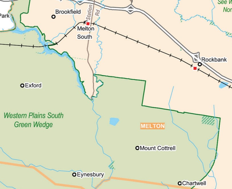
Strathtulloh is within the northern portion of the Western Plains South Green Wedge, which refers to a non-urban land that surrounds the Urban Growth Boundary of Melbourne and was put in place by the Victorian Government in 2002. The city of Melton is preparing a management plan with other surrounding council areas to provide a framework to support sustainable development, land use and management.
- Provide opportunities for agricultural uses, such as market gardening, viticulture, aquaculture, farm forestry and broadacre farming
- Preserve rural and scenic landscapes
- Preserve renewable and non-renewable resources and natural areas (such as water catchments)
- Providing and safeguarding sites for infrastructure that supports urban areas, and
- Provide opportunities for tourism and recreation.
The southern area will be controlled by a management plan for the Western Plains South Green Wedge (WPSGW) that is being prepared and until such time the planning principles of the prepared background report will guide future development. The report can be found here.
Benefits of Strathtulloh
The amendment to the Melton Planning Scheme provides suburb urban structure and redevelopment density direction within the existing Urban Growth Zone (UGZ). The Toolern PSP provides the planning framework to facilitate the new residential community, new schools, sports and recreation areas for future development.
The protection of the open space, parkland and Toolern Creek corridor will be controlled by the existing Public Park / Recreation Zone (PPRZ) and Rural Conservation Zone (RCZ). The existing zoning allows for a series of linear public parklands that can be enjoyed by all future residents.
The envisaged school, sports fields and parks are strategically located within the northern portion of the suburb experiencing urban redevelopment. The future neighbourhood activity centre and surrounding suburbs provide areas that provide social, retail, employment and community infrastructure, with the largest located on Bridge Road adjacent to the northern boundary of Strathtulloh.
Transportation in Strathtulloh
Strathtulloh will be connected to public passenger transport, with Melton train station and Toolner Train Station located in adjacent suburbs north of Strathtulloh. Both stations provide passenger train service to Melbourne CBD.
A shared pathway connects local parks, adjacent suburbs and residential areas in Strathtulloh. A road network is envisaged to connect the large rural residential lots with the approved and proposed residential subdivisions to facilitate vehicle access to the surrounding growth areas. Access to Ferris Road to the north will provide a direct connection to the Melton Highway/ Western Freeway interchange providing access to Melbourne CBD or western Victoria.
Atherstone Residential Community
Property developer Lendlease has begun to establish a large residential community over the Cobblebank and Strathtulloh suburbs, in accordance with the Toolern PSP. The new master planned community is named ‘Atherstone’ and provides a variety of residential allotments, types of dwellings, parks and a local road network. The redevelopment has announced that future stages of development will be released. The redevelopment has protected the Public Park / Recreation Zone (PPRZ) and Rural Conservation Zone (RCZ) and facilitated the intended redevelopment of the Urban Growth Zone (UGZ).
.jpg)
Strathtulloh Suburb Summary
References
City of Milton – Strathtulloh Map
City of Milton – C122 Draft Planning Scheme Amendment
2019—2020 Federal Government Budget Submission
Western Plains South Green Wedge – Background Report
Western Plains South Green Wedge - Map
Victoria Planning Authority – Toolern PSP
Atherstone Master planned Community
Popular Estates near Balmoral Estate - Strathtulloh


Latest New Home Articles for You

09/Mar/2026 | OpenLot.com.au
Victoria: Top 30 Most Searched Housing Developments (February 2026)
If you’ve been exploring housing opportunities in Victoria, February 2026...

20/Feb/2026 | OpenLot.com.au
Display Homes at Drouin Fields Estate: A Thriving Community in Drouin
Welcome to Drouin Fields, a place where beauty, space, and modern luxury ...

19/Feb/2026 | OpenLot.com.au
Display Homes at Manor Lakes Esate: A Thriving Waterside Community in Manor Lakes
A place where you can settle in, rather than just settle down. Named for ...

13/Feb/2026 | OpenLot.com.au
🏠 Victoria: Top 30 Most Searched Townhouse Developments – January 2026

11/Feb/2026 | OpenLot.com.au
🏡 Top 30 Most Searched Estates by State - January 2026

10/Feb/2026 | OpenLot.com.au
Victoria: Top 30 Most Searched Housing Developments (January 2026)
If you’ve been considering making a move in Victoria, January 2026 offere...

10/Feb/2026 | OpenLot.com.au
Queensland: Top 30 Most Searched Housing Developments (January 2026)
If you’ve been considering making a move in Queensland, January 2026 offe...

09/Feb/2026 | OpenLot.com.au
Western Australia: Top 30 Most Searched Housing Developments (January 2026)
If you’ve been considering making a move in Western Australia, January 20...

06/Feb/2026 | OpenLot.com.au
South Australia: Top 30 Most Searched Housing Developments (January 2026)
If you’ve been considering making a move in South Australia, January 2026...