


Oxley Ridge Estate - Cobbitty
[Limited offer] 20 lots land-only sales, pre benched, retaining wall included!
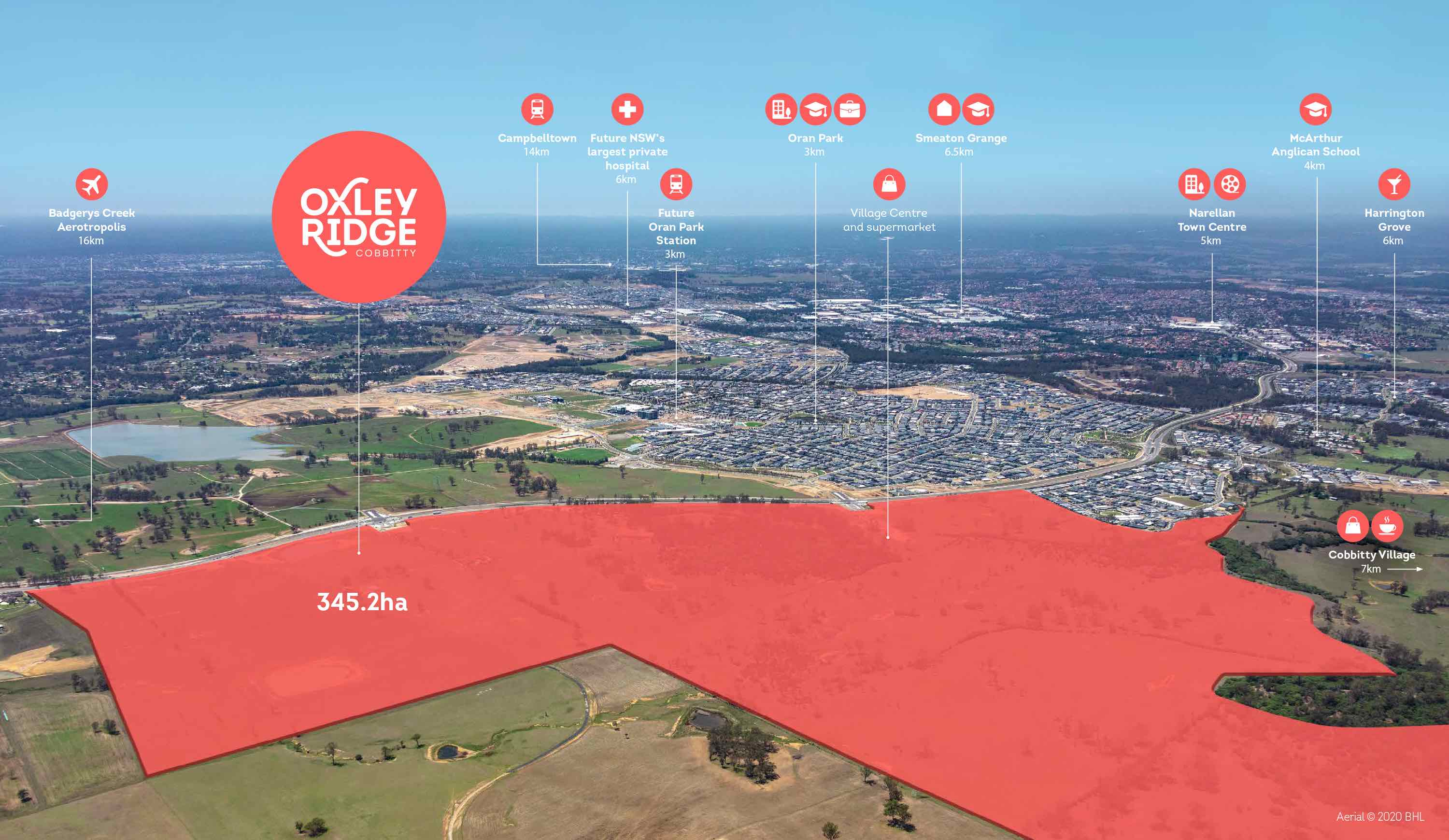
- The newest master-planned community in Sydney’s south-west
- Easy access to a multitude of shopping and dining options in the future Neighbourhood village centre close by.
- Nestled in an elevated location embraced by the natural landscape and country views
- Located close to both public and private schools, shopping and medical.
- Over 10h of parks and open space, a future park with children’s play area, interconnecting designated shared cycle and walkways.
- Land Registration: Mid – Late 2023
This information is estimated by the OpenLot research team. Let us know here to provide up-to-date information about this development.
| Total new homes | 4,500 |
| Area size | 345.20 hectares |
| Growth Region | Sydney South West Growth Areas |
| City council | Camden Council |
| Developer | BHL Group |
| Project marketer | Linden Wise |
| Distance to | Sydney Airport - 42 km west Sydney CBD - 45 km west |
Land for Sale, House and Land Packages:
24 Display Homes in Oxley Ridge Estate Display Village - Cobbitty

 4
4
 2
2
 2
2
 2
5
4
3
2
4
3
2
2
6
3
3
2
4
2
2
2
4
2.5
2
2
4
2.5
2
2
4
2.5
2
2
4
2
2
1
4
2.5
2
1
4
3
2
4
2.5
2
5
3
3
2
4
2
2
2
5
3
3
2
2
5
4
3
2
4
3
2
2
6
3
3
2
4
2
2
2
4
2.5
2
2
4
2.5
2
2
4
2.5
2
2
4
2
2
1
4
2.5
2
1
4
3
2
4
2.5
2
5
3
3
2
4
2
2
2
5
3
3
2
Popular Estates near Oxley Ridge Estate - Cobbitty


Updates for Oxley Ridge Estate - Cobbitty
Facebook updates:
Related news:
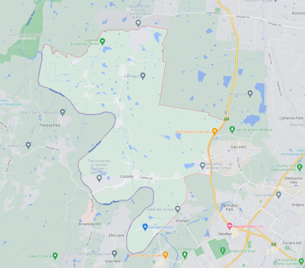
Cobbitty is approximately 5,216.4ha within the north ward of Camden Council and the Hume electoral division in New South Wales, located 60 kilometres south-west of Sydney. The regional area is primarily rural land holdings supported by the Cobbitty Town Centre.
Golden Land Property Group
We're for Sydney

We're for Sydney

Surrounded by pristine countryside and enriched by preserved natural features, Oxley Ridge offers something unique to in the new South West: a direct connection to country. This is the modern Australian dream â and itâs all in your backyard!

Missing articles? Send us a link here.
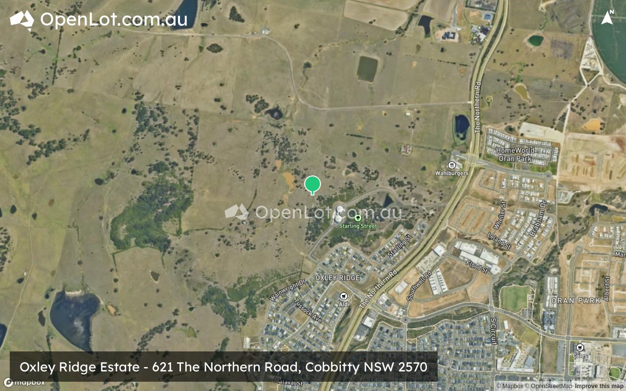
Location & Map for Oxley Ridge Estate - Cobbitty
Vacancy Rate in Cobbitty NSW 2570
View full vacancy rate history in Cobbitty NSW 2570 via SQM Research.
Schools near Oxley Ridge Estate - Cobbitty
Here are 6 schools near Oxley Ridge Estate - Cobbitty:
K-6 Government Primary School
7-12 Government Secondary School
K-12 Independent Combined School
K-12 Independent Combined School
K-6 Government Primary School
K-6 Catholic Primary School
Suburb Planning Review in Cobbitty NSW 2570
Cobbitty is approximately 5,216.4ha within the north ward of Camden Council and the Hume electoral division in New South Wales, located 60 kilometres south-west of Sydney. The regional area is primarily rural land holdings supported by the Cobbitty Town Centre.
The suburb boundary is located along Bringelly Creek to the north and the long winding Nepean River to the west and south. The Macquarie Grove Road and the Northern Road provide part of the boundary to the east, with a series of property boundaries in the northeast. The Camden Airport is also located in the south of Cobbitty, with the University of Sydney establishing research farms in both the north and south of the area.
Cobbity Road, Coats Road and Cut Hill Road provide access to the village, the rural properties and surrounding townships. Rural residential zoned areas dominate the northern, southern and western portions of the suburb, however, contains a cluster of low density development to the eastern boundary.
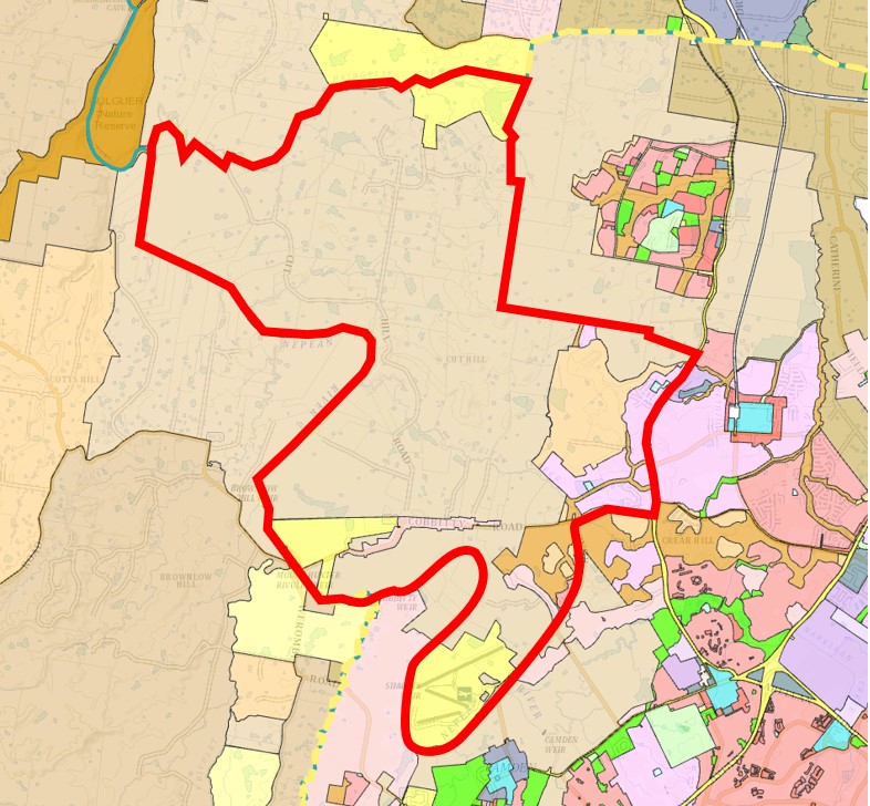
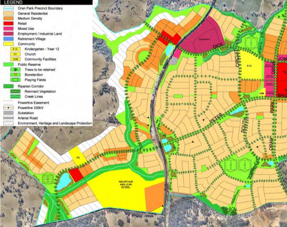
Along both Macquarie Grove Road and the Northern Road, urban areas are being developed under the general residential zoning in an expansion of Oran Park (Local Centre), which is supported by the Oran Park Precinct - Growth Centres Precinct Development Control Plan.
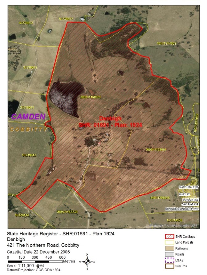
The emerging development wraps around Denbigh, Bangor and Cluny Hill a group of homesteads, buildings and plantations in a large rural setting. The heritage-listed area is of great state significance due to the preservation of the buildings.
Cobbitty: Campbelltown–Macarthur
Cobbitty forms the outer rural area of the Campbelltown–Macarthur a Metropolitan Cluster within the Western Parkland City which will form part of the region plan for Greater Sydney. The vision for the next 20 years is to provide jobs, education, health facilities and services to more residents that live within the new Western Parkland City, drawing on the new Western Sydney Airport and Badgerys Creek Aerotropolis, and North-South Rail Link.
The growth area will create the opportunity for a Western Economic Corridor. The planning priorities and actions for improving the quality of life for residents in this growth area are set down in the Western City District Plan, our greater Sydney 2056, March 2018.
Western City District Plan in Cobbitty
The population growth in the Western City District will be 464,450 by 2036, which is expected to require a housing growth of 184,500 dwellings (25%). The integration of new land use, transport and infrastructure is supported by the Future Transport Strategy 2056 and State Infrastructure Strategy 2018–2038 across the region. The new Western City District Structure Plan illustrates the loction for the future urban growth
Cobbitty Suburb Summary
References
- Camden City Council - Cobbitty DCB
- Cobbitty – Structure Plan for the Western City District
- Cobbitty, NSW - State Heritage Area
- Oran Park – Development Control Plan
- Google Streetview and Aerial
Reviews & Comments on Oxley Ridge Estate - Cobbitty
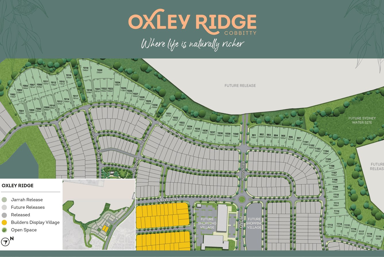
Estate Brochure, Masterplan, Engineering Plan, Plan of Subdivision (POS), Design Guidelines
FAQs about Oxley Ridge Estate - Cobbitty
View all estates from BHL Group
View all estates marketed by Linden Wise
- Oran Park Public School - 1.5km south-east
- Oran Park High School - 1.7km south-east
- Oran Park Anglican College - 2.4km south-east
- Macarthur Anglican School - 2.5km south
- Barramurra Public School - 3.8km south-east
- St Justin's Catholic Primary School - 4.1km south-east
Popular Estates near Oxley Ridge Estate - Cobbitty
Latest New Home Articles for You

16/Mar/2026 | OpenLot.com.au
New South Wales: Top 30 Most Searched Housing Developments (February 2026)
If you’ve been considering a move in New South Wales, February 2026 provi...

09/Mar/2026 | OpenLot.com.au
Victoria: Top 30 Most Searched Housing Developments (February 2026)
If you’ve been exploring housing opportunities in Victoria, February 2026...

20/Feb/2026 | OpenLot.com.au
Display Homes at Drouin Fields Estate: A Thriving Community in Drouin
Welcome to Drouin Fields, a place where beauty, space, and modern luxury ...

19/Feb/2026 | OpenLot.com.au
Display Homes at Manor Lakes Esate: A Thriving Waterside Community in Manor Lakes
A place where you can settle in, rather than just settle down. Named for ...

13/Feb/2026 | OpenLot.com.au
🏠 Victoria: Top 30 Most Searched Townhouse Developments – January 2026

11/Feb/2026 | OpenLot.com.au
🏡 Top 30 Most Searched Estates by State - January 2026

10/Feb/2026 | OpenLot.com.au
Victoria: Top 30 Most Searched Housing Developments (January 2026)
If you’ve been considering making a move in Victoria, January 2026 offere...

10/Feb/2026 | OpenLot.com.au
Queensland: Top 30 Most Searched Housing Developments (January 2026)
If you’ve been considering making a move in Queensland, January 2026 offe...

09/Feb/2026 | OpenLot.com.au
Western Australia: Top 30 Most Searched Housing Developments (January 2026)
If you’ve been considering making a move in Western Australia, January 20...